|
|
|
Pawnee County Museums and Historic Sites |
|
|

|
|
|
|
 Museums: Museums:
Larned:
Central States Scout Museum -
Features one of the best collections of boy and girl scout memorabilia west of
the Mississippi River. 815 Broadway, P.O. Box 392, Larned,
Kansas,
620-285-8938 or 620-285-6427.
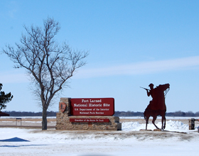
Fort Larned
National Historic Site,
Larned, Kansas -
Established in 1859 on the vast prairie in western Kansas near
the midpoint of the
Santa Fe Trail.
Its
Indian
Agency was also instrumental in maintaining friendly relations with
Plains
Indians.
Today, with nine restored buildings, it is the best preserved Indian wars
military post on the Santa Fe Trail.
The historic fort is located 6 miles west of
Larned,
Kansas on Kansas Highway 156.
Fort
Larned National Historic Site, 1767 Kansas Highway 156,
Larned, Kansas 67550-9321, 620-285-6911.
Santa Fe Trail Center -
A unique museum, library, and educational institution devoted
to the interpretation the Santa Fe Trail. It preserves artifacts and
manuscripts related to the blending of the major cultures along the
Trail and features interpretive exhibits, learning programs
and resource materials. The outdoor portion of the museum includes a
sod house, schoolhouse, and dugout. Located two miles west of Larned
on Highway 156. Route 3,
Larned, Kansas
67550, 620-285-2054.
Historic Sites:
Larned:
Sibley's Camp - This
location was the August 31, 1825 campsite of the
Santa Fe Road survey team and is currently
being developed to give it the semblance of its appearance in
1825. It is located at 502 W. Second in
Larned, Kansas.
 Historic Markers: Historic Markers:
Burdett:
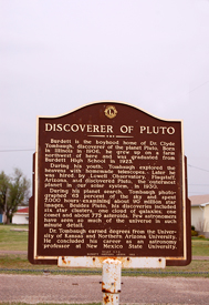
Discoverer of Pluto -
Burdett
is the boyhood home of Dr. Clyde Tombaugh, discoverer of the planet Pluto. Born
in Illinois in 1906, he grew up on a farm northwest of here and was graduated
from Burdett High School in 1925.
the Kansas State historical marker is located on Kansas Highway 156 on the west
edge of Burdett.
Garfield:
Camp Criley, 1872 - Camp Criley was
established in 1872 as a supply station for workmen building the Santa Fe
Railroad, named changed to Garfield
in 1873 by pioneers settling here.
|
|
|
|
This park was planned in 1880 and the first trees planted in April 1882. The
Band Shell erected in the early 1900's used for many concerts by local
musicians. Hitching Post and Stone Stile used in the early days by ladies when
mounting their horse brought from the former A. H. Moffet place. Band Shell and
stone fixtures were restored in 1975 with funds from Jordaan Foundation. M. A.
W. Jordaan and sons were pioneer farmers in the area. Bricks in base of the sign
are from the school building erected in 1884 and made in local kiln.
The Kansas State historical marker is located on US-56 in the City Park in
Garfield,
Kansas.
|
|

Coon Creek Crossing,
photo
courtesy Santa Fe Trail Research.
|
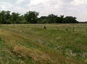
Coon Creek Crossing -
This marker, placed by the Wet/Dry Route of the
Santa Fe Trail Association is located
just north of US Highway 56, about 1.5 miles west of
Garfield, east of a bridge. Coon Creek, which meandered through the area, could be
a troublesome crossing point, and was in an area of considerable hostile Indian
activity. Wagon ruts are still visible on the north
bank of the creek.
Larned:
Birthplace of Farm Credit - This 280 acres
was collateral for the nation's first Federal Land Bank loan made on April 10,
1917 to farmer-stockman A. L. Stockwell. In those days, farmers and ranchers
found credit hard to come by. If available, it was often very expensive . . . as
much as 10 percent per month.
Recognizing the importance of agriculture to our
nation's economy, Congress passed the Federal Farm Loan Act which was signed
into law by U.S. President Woodrow Wilson in 1916. The Federal Land Bank, which
makes long-term real estate loans to farmers and ranchers, was the first of the
three lending institutions which comprise today's cooperative Farm Credit
System.
|
|
Wichita was granted the first of 12 Federal Land
Bank charters nationwide and charged with developing lending programs in Kansas,
Oklahoma, Colorado and New Mexico. In turn, it issued the first local
association charter to the Pawnee County National Farm Loan Association of
Larned.
Originally started with seed money appropriated by Congress, the Farm Credit
System has long since repaid all government funds. Today, it is entirely owned
by the farmers and ranchers it serves.
The Kansas State historical marker is located on US-56, southwest of
Larned, Kansas.
Pawnee Fork Crossing -
This marker, placed by the Wet/Dry Route of the
Santa Fe Trail Association, is located
near the U.S. Highway 56 bridge crossing Pawnee River.
Railroad and highway construction have long since destroyed much of the
historical integrity of the site, but its steep banks still show how difficult
the crossing was. One of the most hazardous fords on the entire length of the
Santa Fe Trail, the east bank was very steep and was 20-30 feet above the water.
Though the west bank wasn’t as nearly as steep, it still required added teams
and/or men to help pull the wagons up.
Compiled
by
Kathy Weiser/Legends
of Kansas, updated March, 2017.
|
|
From Legends' Photo Shop
 Saloon
Style Photo Prints - What were on the walls of
saloons in
the Old
West? Most of the time, it was similar as what you might find
today --
advertisements for liquor, beer, and tobacco. But,
in those
Wild West days, the
walls were often filled with images of
"decadent" women of the time. In our
Photo Print Shop, you'll find dozens of images for decorating a real
saloon or western themed restaurant, or your person home bar in a
saloon style
atmosphere. Saloon
Style Photo Prints - What were on the walls of
saloons in
the Old
West? Most of the time, it was similar as what you might find
today --
advertisements for liquor, beer, and tobacco. But,
in those
Wild West days, the
walls were often filled with images of
"decadent" women of the time. In our
Photo Print Shop, you'll find dozens of images for decorating a real
saloon or western themed restaurant, or your person home bar in a
saloon style
atmosphere.
 |
| |
|