
Old wagon wheels in Pawnee County, Kansas.
| Town | Post Office Dates | Additional Information |
| Antone | 1879-1883 | |
| Ash Valley | 1877-1908 1922-1941 |
Located in Ash Creek Valley, about 12 miles northwest of Larned. |
| Bird Nest | 1883-1891 | |
| Booth | 1881-1884 | The post office moved from Fort Larned. |
| Conkling | 1881-1895 | |
| Fort Larned-Pawnee Fork | 1859-1881 | The name changed from Pawnee Fork in 1866. The post office moved to Booth in 1881. |
| Frizell | 1904-1933 | A money order post-village and station on the Larned & Jetmore division of the Atchison, Topeka & Santa Fe Railroad. Located seven miles west of Larned, it had a general store in 1910. |
| George | 1882-1888 | |
| Green Ridge | 1878-1881 | |
| Harmony | 1877-1908 | Harmony was located near the northwest corner of the county, about 18 miles from Larned. |
| Keysville-Ben Wade | 1877-1893 | The name changed to Ben Wade in 1881. In 1893, the post office moved to Rozel. |
| Lanark | 1878-1883 | |
| Lucas-Marshall | 1878-1894 | The name changed to Marshall in 1886. |
| Nixon | 1878-1889 | |
| Point View | 1879-1912 | A country post office, it was located 11 miles southeast of Larned. |
| Proston | 1878-1883 | |
| Ray | 1878-1884 1889-1929 |
A small village on the Missouri Pacific Railroad, 8 miles east of Larned. In 1910, it had a couple of retail stores, two grain elevators, telegraph and express offices, and a population of about 60. Most of the houses were demolished or moved in the 1950s, and the grain elevator was later torn down. |
| Sanford | 1909-1954 | Only a grain elevator and a few scattered buildings in the area remain. |
| Saw Mill | 1879-1885 | |
| Schadel | 1914-1915 |
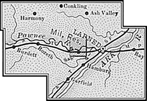
Pawnee County, Kansas Map, 1899.
©Kathy Alexander/Legends of Kansas, updated April 2026.
Also See:
Santa Fe Trail in Pawnee County
See Sources.