
South Hutchison, Kansas.
| Town | Post Office Dates | Additional Information |
| Avery | 1885-1901 | Robert Avery and his brother Cyrus established the town on the land they farmed. Robert Avery was a Civil War veteran who had survived the infamous Andersonville Prison. The first postmaster was George Avery, Jr. At one time, Avery had a store, blacksmith, and post office. The store sold shoes, hats, dry goods, groceries, and cutlery. It was located on Peace Creek, about 20 miles northwest of Hutchinson. |
| Bernal/Elmer | 1887-1913 | Located seven miles south of Hutchinson, Bernal was on the Missouri Pacific Railroad. Though the post office was called Bernal, the railroad called the town Elmer. The town was platted in 1875. South Hutch founder Ben Blanchard even frequented the town. He was trying to sell lots in South Hutchinson and tried drilling for oil. Instead, he found salt and decided to “salt his well with real oil” to develop a bustling city. He stored his supply of oil at Elmer. In 1910, it had telephone connections, was an area trading point, and had a population of 40. During Prohibition, some Hutchinson residents used the Elmer Station to receive liquor, with whisky shipped to the town in five-gallon lots. There is still a metal elevator and a road sign marking its presence.
 Elmer, Kansas Silo  Elmer, Kansas Old Building |
| Bland | 1900-1905 | At least 95 people were being supplied mail at one time. It also had a store. Gus Knoebel owned the land directly north of town and was the first postmaster. Bland was located about 12 miles east of Hutchinson in the Kisiwa Creek Valley. |
| Bone Springs | 1874-1902 | It was located on a tributary of the Ninnescah River, about 25 miles southwest of Hutchinson. Also southwest of Arlington. The community had a school. |
| Buffalo | 1873? | In about 1873, the town had a store, a doctor, a small drugstore, a livery, a dressmaker, a wind-powered flour and grist mill, and a post office. However, the Kansas State Historical Society doesn’t show a post office named Buffalo in Reno County. Joshua Jones homesteaded the northwest quarter of Section 14 in Bell Township in 1873, starting a store in his home. |
| Burrton | 1872 | It was on the Atchison, Topeka & Santa Fe Railroad. The post office was only open for six months. |
| Castleton | 1872-1957 |
 Castleton Depot, 1958 Castleton was laid out in 1872 by W.E. and Clinton Hutchinson and named for C.C. Hutchinson’s sweetheart’s hometown in Vermont. The town grew to 450 people. It had two blacksmiths, a livery, a depot, a meat market, a grocery store, a hotel, restaurants, a hardware store, and a creamer. Located 12 miles south of Hutchison. It still has several area homes, grain elevators, an active church, and named streets. |
| Centre | 1873-1886 | The post office moved to Partridge. |
| Christopher | 1882-1892 | |
| Cottonwood Grove | 1877-1881 | The postmaster was John Thatcher. The post office moved to Turon. |
| Darlow/Booth | 1890-1935 | The name changed from Booth to Darlow on October 2, 1900. It was a station on the Atchison, Topeka & Santa Fe Railroad six miles south of Hutchinson. The town once had a blacksmith, a lumberyard, two elevators, a depot, a grocery store, and a school. In 1910, it had an express office, a money order post office with one rural route, and a population of 75. A few area homes remain. |
| Dean | 1881-1886 | |
| Desire | 1877-1878 | |
| Forsha | 1896-1907 | Located 11 miles south of Hutchinson, it was on the Atchison, Topeka & Santa Fe Railroad. In 1910, it had a flour mill and was a trading center for the neighborhood. |
| Germantown | None | It was said to have one of the best schools in Reno County. It also had a church, a carpenter, a blacksmith, and a hide dealer. It was four miles east and two miles north of Yoder. |
| Huntsville/Noblesville | 1878-1905 | Huntsville was founded in 1878, and its post office closed in 1905. Through the years, it had two stores, a Methodist church, a dance hall, a pool hall, a blacksmith, a hotel, a doctor, and a school. In 1910, its population was 60. Later another place called Noblesville was located on the same site by N.M. Begeman, who ran a filling station and grocery store. Its train station, still often called Huntsville Station, was later converted into a private dwelling. It was between Salt and Peace Creeks, 24 miles west of Hutchinson. |
| Idaville | 1875-1876 | The post office moved to Nonpariel. |
| Jordan Springs | 1875-1887 | Jordan Springs had a school, a store, and a beauty shop. It was located about two miles west and one mile south of Langdon, or 30 miles southwest of Hutchinson. |
| Kent | 1882-1901 1902-1904 |
A station on the Atchison, Topeka & Santa Fe Railroad seven miles east of Hutchinson. In 1882, at least 25 people lived in Kent. It had a school, and the railroad went ran close by it. |
| Langdon | 1873-1992 | The post office moved from Leonville. Langdon was a station on the Chicago and Rock Island Railroad 16 miles southwest of Hutchinson. It is still a very small town with some interesting old buildings. |
| Leonville | 1873 | The post office was only open for six months. It was moved to Langdon. The town was six miles west of Partridge. |
| Lerado/Netherland | 1874-1904 |
 Odd Fellows Hall, Leredo, Kansas. The town was named after Laredo, Texas but was misspelled when the application went in for a post office. A doctor named John Brady was optimistic for the city, which included building a women’s college named after him – Brady University – once the railroad went through. Dr. Brady and the townsfolk prepared for trains by building a $24,000, 100-room hotel and a brickyard operation. At one time, there was a bank, a newspaper, a school, a church, a drugstore, a meat market, a town hall, the lodge and opera house, and four livery barns. The name changed from Netherland to Lerado on May 2, 1884. However, the railroad never came. Instead, the tracks were built through Turon. The former town is on Pretty Prairie and Lerado Roads. Only the cemetery and an old Odd Fellows Hall building remain today. |
| Leslie | 1874-1887 | The town was located 1.5 miles east of Medora. When the post office closed, it moved to Medora. |
| Line | 1879 | The post office was only open for three months. |
| Loda Center | None | It had a school with an enrollment of 34 in the early 1900s. It was located between Lerado and Pretty Prairie, at the intersection of Pretty Prairie Road and Hodge Road. |
| Marietta | 1878-1887 | |
| Medora | 1887-1988 |
 Mendora, Kansas Bunkhouse. The post office moved from Leslie. It was located at the junction of the main lines of the Chicago and Rock Island Railroad with the St. Louis and San Francisco Railroad. In 1910, it had a grain elevator, telegraph and express offices, a money order office, and a population of 75. Today it is a ghost town located ten miles northeast of Hutchinson. |
| Mona | 1879-1901 | A German Mennonite settlement on the Ninnescah River, it was about five miles west of Ost. |
| Mount Liberty | 1873-1886 | A small town in Haven Township. It had the first post office in the township established on March 1, 1873, with S. J. Wilson as postmaster. A Methodist Episcopal church was organized in 1874. A church measuring 35×40 feet was built in 1883 for $2,000. At one time, it had two general stores and a school. It was located on the south side of the Arkansas River, four miles northeast of Yoder. |
| Myton | None | Myton was 25 miles northwest of Hutchinson on Peace Creek. There was a school in the area. |
| New Haven | 1887 | The post office was only open for nine months. It was three miles west and five miles north of Ost. |
| New London | 1873-1881 | The town was part of Rice County until the county line changed, and it became part of Reno County. |
| Nonpariel | 1876-1879 1880-1881 |
The post office moved from Idaville. Also spelled Nonpareil. The town had a school until 1897, when it was disbanded, and students went to nearby Abbyville. |
| Ocoee | 1879-1881 | This place once had a school. |
| Og | 1880-1882 | The town was named after a biblical giant who lived during the time of Moses. It was ten miles west of Castleton. |
| Olcott | 1887-1903 1904-1907 |
The post office moved from Dresden. It was the terminal station on the Olcott & Iuka branch of the Missouri Pacific Railroad and also on a main line of the same railroad. It had a depot, telegraph and express office, hotel, grocery store, Methodist church, grain elevator, a newspaper called the Weekly Press, and a school through the years. In 1910, it had a population of 53. It was located 30 miles southwest of Hutchinson. |
| Ost, St. Joseph | 1882-1911 | In the 1870s and 1880s, Ost had a blacksmith, a barber, and nearly 150 people. In 1910, it was described as a country office and trading center for Sumner Township. The post office closed in 1911. However, it was still home to St. Joseph’s Catholic Church. Later the town began to be called St. Joseph or St. Joe. The church still serves a congregation today as well as a Catholic School. There are several homes in the area. The church is at 13015 E Maple Grove Rd, Mt Hope, KS 67108, 23 miles southeast of Hutchinson.
 St. Joseph Church  St Joseph School |
| Peace Creek | 1876-1905 | It was located at the headwaters of Peace Creek, 28 miles west of Hutchinson. |
| Pekin | 1897-1905 | Pekin was named for a suburb of Peoria, Illinois. At one time, the town had a store, a creamery, an icehouse, a butcher shop, a town hall, a church, a school, a chief of police, and its own telephone company, with nearly 300 phones in the system. The population in 1910 was 40. Pekin was located 15 miles west of Hutchinson and five miles north of Abbyville. |
| Purity | 1880-1893 | A country store opened in 1979, followed by a post office the next year. There also was a blacksmith shop and a gristmill. An 1883 edition of The Hutchinson News stated, “Purity is booming.” However, the post office closed in 1893. It was located 22 miles south of Hutchinson, or about eight miles from Castleton. |
| Queen Valley | 1871-1872 | The first post office in Reno County was in Queen City or Queen Valley. When William Caldwell heard that the Santa Fe Railroad would go through where Cow Creek and the Arkansas River meet, he set up a little town with a post office. The sign on the office said “Queen City.” However, the post office’s name was “Queen Valley.” Caldwell, who ran an inn built of prairie sod, had dreams of it becoming a major metropolis. However, the railroad bypassed Queen City for the future county seat. The post office closed on February 2, 1872, about the time Hutchinson incorporated. It was only open for seven months. |
| Red Rock | None | It didn’t have a post office, but it had an active Grange. It was two miles southwest of present-day Plevna. |
| Riverton | 1875-1890 | |
| Salt Creek | 1873-1886 | The post office moved to Abbyville. |
| Sego | 1874-1905 | Sego had a school, church, general store, constable, and a creamery. The population in 1910 was 16. It was located 18 miles southwest of Hutchinson. |
| South Hutchinson | 1887-1898 | That portion of the city of Hutchinson lies south of the Arkansas River. The population in 1910 was 387. Merged with Hutchison. |
| Stella | 1884-1886 | |
| Stullville | 1879-1880 | |
| Thomas Grove | None | Thomas Grove was Reno County’s first settlement. The John Wesley Thomas family arrived in Reno County in November 1870. They were on their way from Iowa to California by covered wagon when they stopped in the county for the winter. They named the area Thomas Grove, built a sod house, and lived in it and the covered wagon. They never left. A year later, other settlers arrived, including one group with a herd of longhorns. They built a school in 1886 and a new school in 1956. It closed in 1960. |
| Thurber | 1899-1901 | |
| Westminster | 1873-1881 | |
| Woodberry | 1878-1887 | Woodberry was located in southeast Reno County. |
| Yaggy | 1900-1901 | Yaggy, a station on the Atchison, Topeka & Santa Fe Railroad, was located near the intersection of Yaggy Road and Nickerson Boulevard. This was once a 1,350-acre plantation filled with catalpa and apple trees. A post office briefly opened in January 1900 but closed five months later. In 1915, Edward Yaggy sold 210,000 bushels of apples and added cowpeas, potatoes, and sweet potatoes. It soon became the largest shipping point for fruit between the Missouri River and California, employing 300 men during the busy season, and had 30 employees full-time. The town was never incorporated and served as more of a community center. It once had a general store, and local youth attended the Fruit Valley school. Unfortunately, the drought of the 1930s took out most of the trees. Afterward, the plantation became a cattle ranch and farm. |
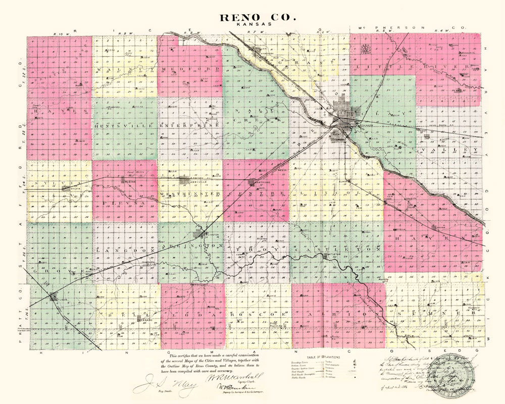
Reno County, Kansas Map, 1887.
By Kathy Alexander/Legends of Kansas, updated June 2025.
Also See:
Sources:
Blackmar, Frank W.; Kansas: A Cyclopedia of State History, Vol I; Standard Publishing Company, Chicago, IL 1912.
Kansas Ghost Towns
Post Offices of Kansas
Reno County Ghost Towns