
Arkalon Park in Seward County, Kansas, courtesy of the City of Liberal.
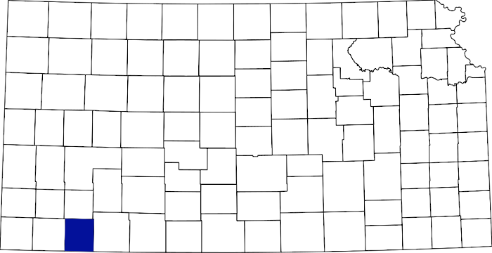
Seward County, Kansas, location.
Towns & Places:
Liberal – County Seat
Extinct Towns of Seward County
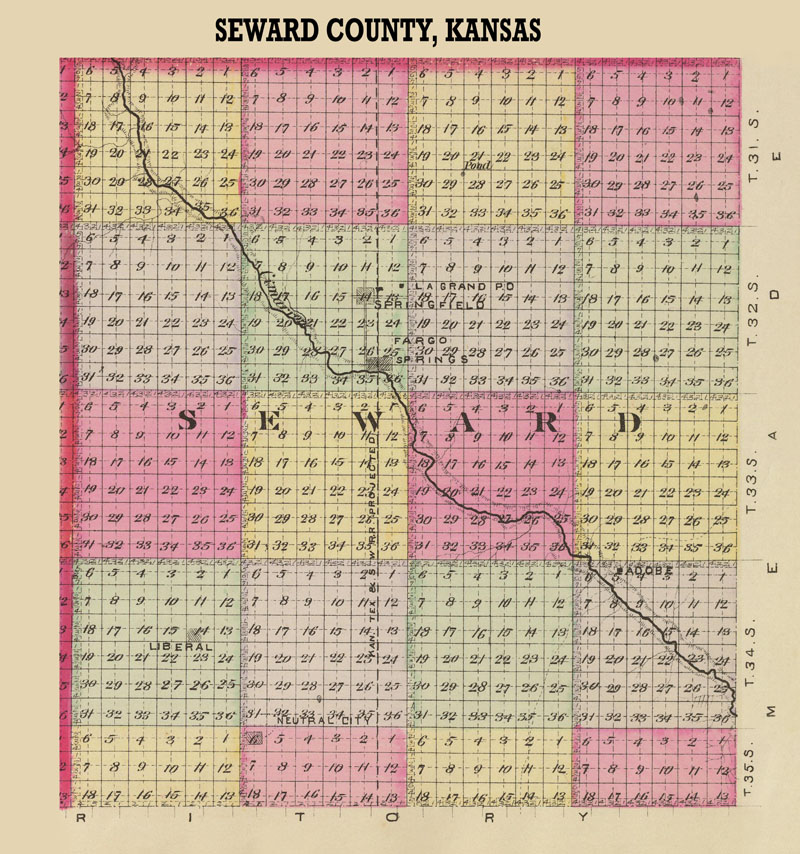
Seward County, Kansas Map by L.H. Everts & Co., 1887.
Seward County, Kansas, is located in the Southwest part of the state. Its county seat and largest city is Liberal. As of the 2020 census, the county population was 21,964. According to the U.S. Census Bureau, the county has a total area of 640 square miles, of which 639 square miles is land and 1.0 square mile is water.
Seward County is the third county east of Colorado. It is bounded on the north by Haskell County; on the east by Meade County; on the south by the State of Oklahoma, and on the west by Stevens County.
The general surface is undulating, with few hills, and there was practically no timber. The Cimarron River entered near the northwest corner and flowed southeast into Meade County. Good-quality limestone was found in the southwest portion.
The county was created on March 20, 1873, and named in honor of William H. Seward, the New York governor and Secretary of State under Presidents Abraham Lincoln and Andrew Johnson. In its early years, Seward County went through several boundary changes.
On February 22, 1883, Seward County was expanded to include Morton, Stevens, and part of Meade Counties.
The settlement within Seward County’s present boundaries did not begin until 1884. Among the first settlers, who afterward became prominent in the business and political life of the county, were W.J. Tipton, who came in 1884, and the following, who came in 1885: Oliver Leisure, L.J. Fulton, L.P. Roberts, Harry C. Nelson, A.T. Ragland, E.M. Campbell, A.H. Saunders, L.A. Etzold, J.M. Adams, and J.L. Lundsford.
Seward County is primarily an agricultural and livestock county. Cattlemen were the first white settlers of this region, and while they were few in number, their cattle grazed over a vast area.
On March 13, 1885, Meade County was re-established.
Seward County was initially administered from one of several neighboring counties until the Finney County commissioners organized Seward County as a municipal township of Finney County on June 10, 1885, with the temporary seat of government at Sunset City. The township was divided into two voting precincts—one headquartered in Sunset City and the other in Fargo Springs. Almost immediately, a rivalry between Fargo Springs and Springfield erupted, becoming so intense that both towns sent armed contingents to the other to prevent their voters from reaching the polls, leading to a disputed election in 1885.
Immigration was heavy in 1885 and 1886.
On February 20, 1886, Morton and Stevens Counties were re-established.
In March 1886, C.L. Calvert was appointed census taker, and according to his returns, which were made on June 5, there were 2,551 bona fide residents in the county, of whom 843 were householders. The taxable property amounted to $421,985, of which $182,719 was real estate.
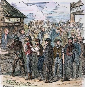
Voting in Kansas.
The county was organized on June 17, 1886, with Governor John A. Martin designating Springfield the temporary county seat. Fargo Springs was the rival of Springfield for the county seat, and the governor, hoping to divide the spoils, appointed Fargo Springs adherents as commissioners. He appointed the following officers: County Clerk, J.M. Wilson; commissioners, Walter H. Harwood, E.M. Campbell, and Edwin A. Watson. They divided the territory of the county into election districts in such a manner as to give their town the advantage over Springfield. The voting place for Seward Township was at Fargo Springs.
The night before the election, held on August 5, 1886, it is said the Fargo men, 40 strong, took possession of the polling place, organized the election board early the next morning, and began voting an hour before the time fixed. It was charged that the Fargo people “voted early and often.” The farmers, not approving of how the election was conducted, hauled a wagon up beside the building where the polls were located and set up a voting booth of their own. The commissioners refused to canvass the vote deposited in the ballot box in the wagon bed. There were 225 votes cast in this manner, of which a majority were for Springfield. The matter was taken to the courts, the commissioners were compelled to canvass the vote, and Springfield was declared the permanent county seat in March 1887. Fargo Springs, located less than four miles south of Springfield, moved to Springfield.
The officers chosen at the August election were: County Clerk, Oliver Leisure; treasurer, Adam T. Ragland; probate judge, L.A. Etzold; register of deeds, George Ferner; sheriff, George Neeley; coroner, Dr. W.H. Dorsett; surveyor, A.L. Stickel; attorney, C.J. Traxler; clerk of the district court, W. E. McClure; commissioners, E.M. Campbell, W.W. Kimball and Charles Mayo.
The county was divided into three townships: Fargo, Liberal, and Seward.
The Chicago, Rock Island & Pacific Railroad came to Seward County in 1888, connecting southwest Kansas to the rest of the country. The railroad entered on the eastern boundary line, north of the center, and crossed southwest into Oklahoma, a distance of 30 miles. Towns sprang up all around the state, from Liberal in the west to the town of Arkalon, built by the crossing of the Cimarron River. By August, four months after it was laid out, Liberal’s population had reached 800, and it was incorporated as a third-class city. The people of the southern part of the county began a campaign to make it the county seat.
A railroad trestle bridge, built across the Cimarron River in 1888, soon washed away.

Train wreck over the Cimarron River in Seward County, Kansas, early 1900s.
In the following decades, one by one, the railroad bridges across the Cimarron River malfunctioned due to frequent flooding, costing the Rock Island Railroad thousands of dollars in equipment, supplies, time, and manpower. Even when the bridges were operational, the river’s changing elevation and shape required hairpin turns and miles of curved track, drastically slowing freight. The deep, heavy sand also made it difficult to ship goods on horseback and made farming unprofitable.
In 1890, the county’s population was 1,503. That year, the county records were burned at Springfield, and it came to public notice that the county had a bonded indebtedness of $100,000 with practically nothing to show for it.
The county seat dispute was finally settled when the railroads bypassed both Fargo Springs and Springfield in favor of an alignment through southern Seward County, spurring the rapid growth of Liberal.
On December 8, 1892, the last county seat election was held. The candidates were Liberal and Springfield. The former won by 125 votes. So confident were the Liberal adherents of a victory that a large number of farm wagons were drawn up before the county offices, and as soon as the vote was announced, the removal of the county property began. In less than three hours, it was all on the road to Liberal.
The first courthouse was a two-story structure designed by J.M. Smith and built in Liberal in 1892.
In 1900, the county’s population was 822.

Seward County, Kansas, Farm, about 1905.
In 1910, the county’s population was 4,091. This significant increase over the last decade was due to improved farming methods and to farmers learning how to manage the soil in the climate of southwest Kansas to their best advantage.
The total value of farm products in 1910 was $885,529. Wheat, the most valuable crop, brought $258,152; milo maize, $138,270; broomcorn, $110,022; corn, nearly $70,000; Kafir corn, $81,825; hay, $55,634; animals sold for slaughter, $80,701. The livestock totaled 10,537 head, valued at $561,618, and the assessed property valuation was $6,117,868.
By the end of the 1920s, Arkalon was no more.
In the 1930s, the area’s prosperity was severely affected by its location within the Dust Bowl. This catastrophe intensified the economic impact of the Great Depression in the region.

Chicago, Rock Island & Pacific Railroad bridge over the Cimarron River during the flood of 1938.
On August 18, 1938, the problem with the railroad bridge across the Cimaron River came to a head. The Rock Island’s fast freight train, the Gold Ball, pulling 30 tank and freight cars, slowed down to 30 miles per hour to negotiate the first part of the hairpin turn at the Arkalon crossing. In an instant, the bridge gave way completely. The engine and 12 of the freight and tank cards fell into the swollen river. The final collapse resulted in two deaths, four injuries, and an engine and 30 train cars falling into the Cimarron River. Crews immediately worked around the block to repair the damage, and three days later, the bridge reopened. A month later, more rain washed away the newly-repaired bridge.
Over the summer, the bridge was quickly repaired, and just as quickly washed out once again. Families began to congregate around the river to gawk, and hamburger stands popped up near the site of the crash. Fed up, Rock Island’s Chief Operating Officer, John Farrington, made the bold decision to route the railroad high over the river.
The new bridge, called the Samson of the Cimarron, is a majestically named railroad bridge that towers over the Cimarron River and spans U.S. Highway 54 in southwestern Kansas. When it was completed on July 8, 1939, it elevated the train tracks 113 feet above the riverbed below, solving more than half a century of headaches, including bridge collapses, train wrecks, and the disappearance of the city of Arkalon. The bridge is 1,268 feet long, and its concrete pillars have been driven 65 feet deep below the riverbed into the soft sand.
It was one of the outstanding engineering achievements of its era. The railroad bridge is about ten miles northeast of Liberal, Kansas. There is a picnic area off of U.S. Highway 54 near the east end of the bridge.
“It helped speed the commerce of the Southwest to its destination, and Arkalon to oblivion.”
— Historical Sign

Sampson of the Cimarron bridge in Seward County, Kansas, courtesy of Kansas Sampler.
The mighty Samson of the Cimarron is easily accessible and visible to anyone driving along U.S. 54. It’s located 13 miles northeast of Liberal, between Kismet and Liberal. Near the bridge is a state-operated roadside park with bathrooms and picnic facilities.
The present Seward County courthouse was built from 1956 to 1957. The modern-style building was designed by W.I. Fisher and Company and constructed by the Irvinbilt Company. The west-facing building is a one-story buff-colored brick, glass, and concrete structure located on landscaped grounds in the center of Liberal.
The building has an extended roof over the existing building’s edge. On the west front is a large wall. Inside, the County District Court is located on the building’s northwest side. There is another large courtroom and two small courtrooms. The building houses the County District Court of the 26th Judicial District, which includes Grant, Haskell, Morton, Stanton, and Stevens Counties. On the north side is the County Administration Building. The old courthouse was demolished when the second and present courthouse was constructed. The courthouse is at the intersection of 415 North Washington Avenue and East 5th Street.

Seward County Courthouse in Liberal, Kansas, courtesy of American Courthouses.
Seward County’s population peaked at 22,952 in 2010.
The demographics of Seward County have changed from a largely non-Hispanic white population in the 20th century to a majority Hispanic population in the 21st century. In 1990, Hispanics in the county accounted for 19.7% of the population; in 2022, they accounted for 66.2%. Seward County has a larger percentage of Hispanics in its population than any other county in Kansas. The Hispanic population increased because, in 1992, National Beef began operating a large meatpacking plant in Liberal that employs 3,500 people, most of them Hispanic. The meat packing plant is the largest employer in the county.
The county is served by two Unified School Districts — Liberal USD 480 and Kismet-Plains USD 483. It also provides the Seward County Community College.
Seward County attractions include the International Pancake Day Hall of Fame, Dorothy’s House/Land of Oz, and the Seward County Coronado Museum, all located in Liberal, Kansas.

Dorothy’s house in the Land of Oz in Liberal, Kansas, by Kathy Alexander.
©Kathy Alexander/Legends of America, updated December 2025.
Also See:
Sources:
Atlas Obscura
American Courthouses
Blackmar, Frank W.; Kansas: A Cyclopedia of State History, Vol I; Standard Publishing Company, Chicago, IL 1912.
Fort Hays State University
Kansas Sampler
Wikipedia