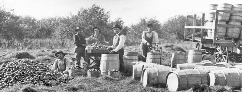
Apple harvest in Wabaunsee County, 1899.
| Town | Post Office Dates | Additional Information |
| Bradford | 1890-1941 | A station on the Atchison, Topeka & Santa Fe Railroad, it was 21 miles southeast of Alma. In 1910, it was a shipping and supply point for the area with a population of 63. |
| Cedar | 1862-1863 | |
| Chalk/Chalk Mound | 1873-1907 | The name changed from Chalk Mound to Chalk on August 1, 1894. It was in the extreme southwest corner of the county, about 17 miles south of Alma. |
| Cobb | 1874-1877 | |
| Copp’s Station | 1866 | The post office was only open for three months. |
| Elvenia | 1880-1885 | |
| Exonville | 1870-1871 | |
| Fairfield | 1880-1889 | |
| Farmer | 1900 | The post office was only open for two months. The Order of change was rescinded. |
| French Valley | 1874-1883 | |
| Grimm | 1873-1883 | |
| Halifax-Bismarck-Hessdale | 1869-1915 1917-1937 |
The name was changed from Bismarck to Halifax on October 20, 1885. It was located in Mill Creek Township and was a station on the Atchison, Topeka & Santa Fe Railroad. In 1910, it had an express office, some general stores, a money order office, and a population of 40. It was six miles south of Alma. After the post office’s closing, the railroad renamed the station Hessdale. Though it was a significant cattle shipping railhead on the Atchison, Topeka & Santa Fe Railroad spur line in Wabaunsee County, a post office was not re-established. The Hessdale stockyards closed in the early 1970s. |
| Keene | 1877-1901 | Some of the earliest pioneers of Wabaunsee County settled a mile east of Keene in 1856 at a small settlement referred to as Fremont, Kansas. One of the earliest businesses in the area was a cheese plant, first owned by Ambrose and Orra Wade and later by Thomas Rutledge. In 1872, the town was moved further west, a mile from its original location, and officially named Keene. In 1910, it had one general store. There are still a few homes in the area, and the Keene Cemetery is about one and a half miles east on Highway K-4. Keene was located on Kansas Highway 4, about five and a half miles west of Dover, Kansas, and 16 miles east of Alma. |
| Mansfield | 1883-1887 | |
| Mission Creek/Grant | 1870-1886 | The name changed from Grant to Mission Creek on February 23, 1875. |
| Moltke | 1873 | The post office was open for less than a month. |
| Newbury | 1870-1888 | |
| Pavilion | 1871-1903 | It was located seven miles north of Alma |
| Pike/Albion | 1880-1887 | The name changed from Albion to Pike on January 4, 1883. When it closed, the post office moved to Alta Vista. |
| Post Creek | 1879-1877 | The post office moved to Willard after it closed. |
| Rockton | 1873-1884 1885-1886 |
|
| Rocky Ford | 1877-1878 | |
| Snokomo | 1875-1881 1886-1901 |
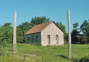
 Snokomo Schoolhouse. Snokomo was located ten miles east of Alma. |
| Sunbeam | 1904-1909 | |
| Templin | 1873-1904 | It was five miles northeast of Alta Vista. |
| Vera | 1889-1904 | It was located on the Chicago and Rock Island Railroad, four miles east of Paxico. |
| Volland | 1887-1955 | A country office in Washington township on the Chicago, Rock Island & Pacific Railroad was eight miles from Alma. In 1910, it had a general store, telegraph and express offices, and a population of 26. |
| Wabaunsee | 1855-1944 |
The first settlement was made here in 1854. It was the county seat from 1859 to 1866. |
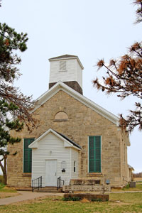
| Wilmington | 1857-1906 | Wilmington was organized in 1858 with 30 houses, two stores, a blacksmith, two doctors, a wagon shop, and a hotel along the 100-foot-wide road that ran east from here. The old station on the Santa Fe Trail, in Wilmington, was home to Company A of the Santa Fe Battalion, Kansas State Militia, in the Civil War. The Leavenworth Military Road joined the Santa Fe Trail here. When the Manhattan, Burlingame & Alma Railway was built through Harveyville four miles north, the businesses moved there. The Stone School and the Church of Christ were built in 1870. The population in 1910 was 69. The school closed in 1950, but still stands. The church also still stands, serving a tiny population. It is located 25 miles southeast of Alma, the county seat, and six miles west of Burlingame in Osage County. |
©Kathy Alexander/Legends of Kansas, updated May 2025.
Also See:
Wabaunsee County Photo Gallery
Sources:
Kansas Post Office History
Wabaunsee County Historical Society & Museum


