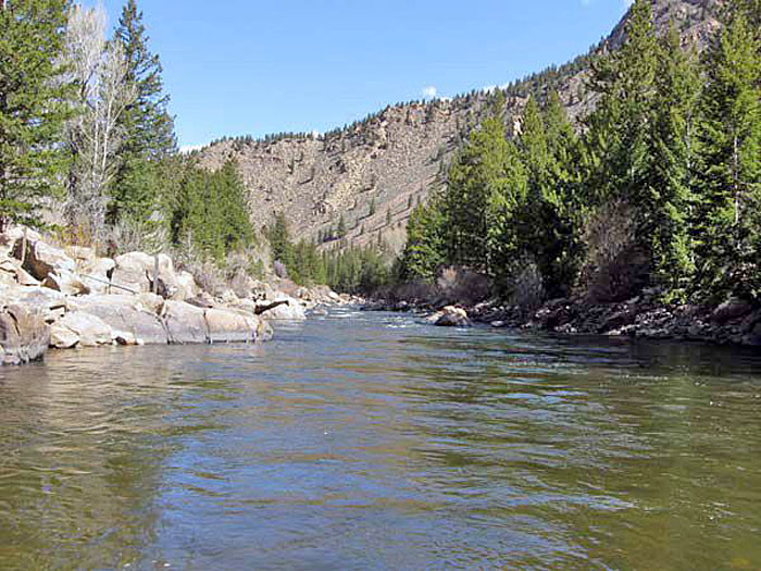
Arkansas River Below Granite, Colorado.
The surface of the Arkansas River Lowlands is a relatively flat alluvial plain made up of sand, gravel, and other sediment deposited by a meandering Arkansas River. Over the last ten million years, the river has flowed into the state from high in the Rocky Mountains of Colorado, where its source is fed by runoff from rain and snowmelt.
In the Rocky Mountains, the Arkansas River is fed by runoff, snowmelt, and rock debris that erode from the surrounding mountains. The Arkansas River Lowlands is an area of flat floodplains covered with gravel and quartz-based sand deposited by the Arkansas River that cuts through the High Plains and into south-central Kansas. Primarily south of the river, inactive sand dunes are found, anchored by plant roots. While most of the region corresponds to the river’s course from Hamilton County to Cowley County, it also encompasses an area of irregular grass-capped sand dunes stretching south of the Arkansas River. The sandy floodplain of the Arkansas River Lowlands region is a unique ecosystem, but one that poses the most significant challenges to farmers. Mining for sand and gravel has become an essential industry in this region.
Very little water is added to the river as it crosses the High Plains in Kansas, and much of the river water eventually seeps into the ground or evaporates. In places where groundwater is near the surface, it interacts with the river, thereby sustaining its flow. As groundwater levels have declined in recent years, rivers in parts of western Kansas often dry up. Streams flowing into the Arkansas River in central and eastern Kansas replenish the water supply.

Arkansas River, near Lakin, KS. Photo by Kathy Alexander.
In much of the region away from the riverbed, the sediment is topped with soil, which is good for farming. Today, the dunes south of the river are covered with grass and other vegetation, which keeps the sand from shifting. These dunes are considered inactive—that is, they are no longer moving in response to wind and water.
The Wellington Formation, a shale unit, underlies East of Hutchinson, the Arkansas River Lowlands. Gypsum appears in parts of the Wellington Formation, particularly in outcroppings along Gypsum Creek on the east side of Wichita.
The soil primarily consists of sand, silt, and gravel deposited by the Arkansas River as it flows from the Rocky Mountains. However, some higher-quality soils are found away from the river. Sand, however, predominates; its extraction has become an essential industry in this region.
Sage prairie vegetation covers most of the Arkansas River Lowlands region. Species include sand sagebrush, sand bluestem, little bluestem, and prairie sandreed.
Arkansas River in Wichita, Kansas by Kathy Alexander.
As one travels from east to west across the region, the climate becomes progressively drier, sunnier, and windier. Annual precipitation ranges from about 30 inches near Wichita to about 15 inches near the Colorado state line. The growing season also becomes shorter as one moves west.
Water has long been a significant concern in the Arkansas River Lowlands. Irrigation and evaporation pull more water out of the river than the low levels of precipitation can replace. Much of the Arkansas River is dry throughout part of the year, sometimes long enough that crops have been grown in the riverbed. Although the perennial disappearance of the Arkansas River is often attributed to irrigation and has long been a point of contention between Kansas and Colorado, this tendency predates any significant white settlement. It is true, however, that irrigation has accelerated water depletion, sometimes dramatically.
The Arkansas River serves as a haven for wildlife species that depend on water. Flocks of migrating shorebirds congregate in this region seasonally in spectacular numbers. The threatened Arkansas River shiner is a fish species native to this region.
Rangeland and cropland both have their place here, although cropland generally predominates in all but the westernmost part of the region. Winter wheat is the main dryland crop. Thanks to irrigation, however, alfalfa and sorghum are also grown in the Arkansas River Lowlands.
Although most Kansas streams are privately owned, the Arkansas, Missouri, and Kansas Rivers are open to the public between the high-water marks on each bank, as indicated by debris left by rising water. Most land beyond that is private and requires the landowner’s permission to access. Public access points on the river are available through the Kansas Department of Wildlife and Parks, Rivers and Streams Access.

Cheyenne Bottoms, Kansas by Gerald W. Tomanek, Kansas Geological Survey
Other points of interest in the Arkansas River Lowlands region include Cheyenne Bottoms north of Great Bend and Pawnee Rock west of Great Bend in Barton County; Quivira National Wildlife Refuge in northeastern Stafford County; and Sand Hills State Park in Reno County northeast of Hutchinson.
When you see the Arkansas River today, fording it might not seem difficult. But today’s Arkansas River is a shadow of its former self, having undergone significant changes since the days of settlement. Now, dams, irrigation, and low rainfall in Colorado and western Kansas draw off much of the river’s flow before it reaches central Kansas.
In comparison, Washington Irving described the Arkansas River when he visited Barton County in 1832:
“After resuming our march, we came in sight of the Arkansas. It presented a broad and rapid stream bordered by a beach of fine sand, overgrown with willows and cottonwood trees. Beyond the river, the eye wandered over a beautiful campaign country of flowery plains and sloping uplands, diversified by groves and clumps of trees and long screens of woodland; the whole wearing the aspect of complete and even ornamental cultivation, instead of native wilderness.”

Covered wagon crossing the Arkansas River at Great Bend, Kansas, in 1872.
In Kansas, the river and region are pronounced Ar-Kansas. The town of Arkansas City, Kansas, is also pronounced Ar-Kansas, but in other states, the river is still pronounced Ar-kansaw.
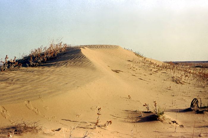
Sand dunes in Kearny County, Kansas, courtesy of the Kansas Geological Survey.
©Kathy Alexander/Legends of Kansas, updated December 2025.
Also See:
Sources:
Homestead on the Range
Kansas Geological Survey
Kansas Geological Survey-1999
Kansas Wetlands & Wildlife