
Several old buildings in the area have been rescued and moved to the Barton County Museum in Great Bend, Kansas, by Kathy Alexander.
In its early years, Barton County boasted more than two dozen towns. Today, most of those towns are extinct.
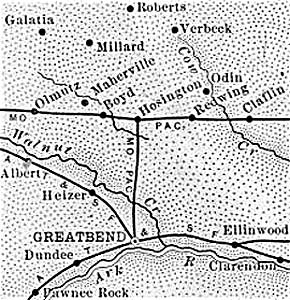
Historic Map of Barton County, Kansas.
| Town | Post Office Dates | Additional Information |
| Beaver | 1919-1992 | Beaver is an extinct town in Beaver Township of Barton County, Kansas. However, it is a census-designated place, and as of the 2020 census, the population was 52. |
| Bloomingdale | 1876-1883 | This small settlement was on Cow Creek in Independent Township in the northeastern part of Barton County. In 1878, its mail was delivered weekly to I.T. Spring, the postmaster. It was 22 miles from Great Bend, the county seat, and 12.5 miles from Ellinwood, on the Atchison, Topeka & Santa Fe Railroad. The Bloomingdale Cemetery is about three miles northwest of Claflin, Kansas, at NE 130 Road and NE 120 Avenue. |
| Bonewitz | 1882-1884 | |
| Boyd/Maherville | 1874-1937 | This village in Eureka Township was first called Maherville when it began as a station on the Missouri Pacific Railroad in 1873. It is four miles west of Hoisington and 12 miles northwest of Great Bend on NW 40 Avenue, south of NW 110 Road. |
| Brooklyn | 1883-1887 | |
| Buena Vista | 1879-1887 | The post office moved to Hoisington in April 1887. |
| Cheyenne Bottom | 1875-1877 | A small settlement in the central part of Barton County, six miles northeast of Great Bend, the county seat. |
| Clarence | 1874-1887 | This small settlement was formed in 1873 on Dry Walnut Creek in the southwest corner of Barton County. In 1878, it had a physician, and its mail was delivered four times per week to L.S. Pursell, the postmaster. It was on the stage line between Great Bend and LaCrosse. It was 18 miles from Great Bend, the county seat, and eight from Pawnee Rock, on the Atchison, Topeka Santa Fe Railroad, its nearest shipping point. The post office moved to Bartholdi when it closed in February 1887. |
| Dundee | 1881-1902 1915-1943 |
Dundee is a tiny, unincorporated community in Barton County, Kansas. It is also an extinct town, as its post office closed decades ago. It still supports a grain elevator, several silos, a few homes, a cemetery, and a couple of old business buildings. |
| Galatia | 1889-1966 | Galatia is a small town in Fairview Township in northwestern Barton County, Kansas. It is also an extinct town, with no post office. |
| Heizer-Heizerton | 1887-1954 | In 1891, the post office and the town’s name were changed from Heizerton to Heizer. Today, it is a ghost town. |
| Leoville | 1880-1881 | The post office moved to Nathan. |
| Lott | 1880-1882 | |
| Millard | 1877-1906 | Named for Francis Millard, the postmaster. |
| Natha | 1881-1887 | The post office moved from Leoville. |
| Odin | 1887-1906 1950-1995 |
Odin, Kansas, is an extinct town on Cow Creek in the northeastern part of Barton County. It is also a census-designated place. As of the 2020 census, the population was 87, and its total area was 4.0 square miles. |
| Pride | 1879-1883 | |
| Putnam | 1878-1883 | |
| Redwing | 1892-1896 1903-1955 |
 Old Tavern in Redwing, Kansas, by Kathy Alexander. Situated on the Missouri Pacific Railroad on Kansas Highway 4, six miles east of Hoisington. In 1910, it had a flour mill, several general stores, a blacksmith shop, a money order post office with one rural route, and a population of 60. Today, there are just a few scattered homes and buildings. |
| State Center | 1879-1894 | |
| Stickney | 1898-1913 | A country post office in Wheatland Township, this town was located about 22 miles north of Great Bend and 11 miles from Hoisington, the nearest shipping point. In 1910, there was a general store and a population of 23. |
| Susank | 1921-1991 | Susank, Kansas, is a very small town in Barton County. It is also an “extinct town,” as it no longer has a post office. As of the 2020 census, its population was 31. |
| Thomas | 1880-1882 | |
| Verbeck | 1878-1904 | An inland hamlet in Barton County, it was located 21 miles northeast of Great Bend and 12 miles northeast of Hoisington, the nearest shipping point and the post office from which its mail was distributed by rural route after its post office closed. The population in 1910 was 29. |
| Webb | 1880-1889 |
©Kathy Alexander/Legends of Kansas, updated December 2025.
Also See:
Sources:
1878 Gazetteer and Business Directory, R.L. Polk & Co., Chicago, IL.
Blackmar, Frank W.; Kansas: A Cyclopedia of State History, Vol I; Standard Publishing Company, Chicago, IL 1912.
Cutler, William G.; History of Kansas; A. T. Andreas, Chicago, IL, 1883.
Fort Hays State University
Kansas Post Office History