
Atchison, Topeka & Santa Fe Railroad shed depot in Hall’s Summit, Kansas by H. Killam, 1952.
Town |
Post Office Dates |
Additional Information |
| Agricola-Hardpan | 1875-1974 | The name changed from Hardpan to Agricola on January 24, 1876. In 1910, it was a station on the Atchison, Topeka & Santa Fe Railroad. At that time, it had telegraph and express offices, a money order post office with one rural route, and a population of 100. It was in Rock Island Township, 20 miles northeast of Burlington, and six miles from Waverly. |
| Aliceville | 1883-1994 | Located in Avon Township of Coffey County is an extinct town because it no longer has a post office. However, it is also an interesting ghost town with several buildings, a profitable bank, and an active church. |
| Aurora | None | A couple of men were sent to Kansas in the summer of 1857 to select a townsite for a company in Aurora, Illinois. The two agents left Lawrence in a wagon loaded with commissary stores, including a jug of whisky, intending to select a point on the Neosho River for the town. On the second night, they camped on a bleak prairie, about six miles south of Torquois Creek, in what is now Rock Creek Township. During the night, the whisky gave out, and there being no prospect of replenishing their stock without returning to Lawrence, they selected the spot where they camped that night for the townsite and returned to Aurora, where they made a flattering report to the home company of the result of their mission. The new town, Aurora, was surveyed and platted, a house was erected, and an unsuccessful attempt was made to dig a well. Nothing else was done, and the enterprise was soon abandoned. The house was occupied for many years by Thomas Dixon and his family, and the place was known as Dixon’s Lone House. It was kept as a house of public entertainment. |
| Avon | 1865-1888 | |
| Bagdad | 1889-1890 | The post office was open for less than seven months. |
| Bancroft | 1876-1882 | |
| Bangor | 1871-1886 | Located at the junction of Dinner and South Big Creeks, it was founded by people from Boston, Massachusetts. A post office moved from Fredericktown, and the name was changed to Bangor. The first settlements and improvements were made in 1872. Before leaving Boston, the members of the colony elected township officers, assuming that the place they were going to was an uninhabited wilderness. Twelve business and dwelling houses were erected, but owing to dissensions among the people, the town sickened and died, and the buildings were removed to neighboring farms. The last building remaining was a hotel, which was removed by F. A. Atherly, in October 1882. The post office moved to Gridley. |
| Bellgrade | 1883-1886 | |
| Bluffton | 1888-1892 | |
| Brown | None |
 Missouri, Kansas & Texas Railroad sign board, by H. Killam, 1957. A station on the Missouri, Kansas & Texas Railway. |
| California | None | This place was located on Benedict Creek in the spring of 1858. However, no buildings were ever erected there. |
| Camp Creek | 1857-1865 | |
| Chickasaw | None | Started in 1857 by parties in Louisville, Kentucky, as a rival to Hampden. Its location was a mile east of Hampden. It was purely a paper town, with no improvements ever made there. |
| Corona | 1870-1878 | |
| Crandall | 1888-1906 | |
| Crotty | 1887-1906 | |
| Dixon | 1872-1878 | The post office moved to Halls Summit. |
| Eclipse | 1873-1883 | The post office moved to Antioch. |
| Ethel | 1899 | The post office was open for less than five months. Order of change rescinded. |
| Fredericktown | 1866-1871 | The post office moved to Bangor. |
| Halls Summit-Warnerton | 1878-1935 | The post office moved from Dixon. It was named for Ezra E. Hall, postmaster. The name was changed from Halls Summit to Warnerton on July 10, 1884. It changed back to Halls Summit on February 25, 1890. In 1910, it was a station on the Atchison, Topeka & Santa Fe Railroad. At that time, it had a bank, various lines of mercantile interests, telegraph and express offices, and a money order post office with one rural route. The population in 1910 was 125. It was located 14 miles north of Burlington. |
| Hampden | 1857-1858 1864-1866 |
Hampden was the county seat from May 23, 1863, to November 24, 1865, when it lost out to Burlington. |
| Key West-Queen City | 1871-1885 | The name changed from Queen City to Key West on December 20, 1877. |
| Kong | 1890-1901 | |
| Lebo Creek | 1872-1880 | |
| Martindale | 1871-1880 | |
| Moody | None |
 Missouri, Kansas & Texas Railway in Moody, Kansas by H. Killam, 1957. A station on the Missouri, Kansas & Texas Railway. |
| Nashville | 1858-1866 | This town was located in Star Township. Its founders were W.J. Sanders, John J. Sanders, G.W. Campbell, and Mr. Caseboom. Platted in the spring of 1858, it had a store, blacksmith shop, a post office, and a half dozen dwelling houses. It declined during the 1860 drought and later became a farm. |
| Neosho City | 1857-1861 | Founded in 1856 by Marcus J. Parrott, Joel K. Goodin, and others in Neosho Township. A hotel, store, sawmill, and other buildings were erected early on. The town failed, however, to attract settlers, and by an act of the Territorial Legislature on February 27, 1860, the town was vacated, and the plat and record annulled. |
| Oread | None | This was a paper town located near Wesley Stubblefield’s farm, ten miles northeast of Burlington. It was started as speculation by a party of Lawrence men, of which Governor Robinson was the head, in the winter of 1856-57. B. L. Kingsbury surveyed the town in the spring of 1857, and many shares in the town, of ten lots each, were sold by the proprietors. No houses were ever built there. |
| Ottumwa | 1857-1906 | Located on the Neosho River in Ottumwa Township, Ottumwa was established in 1857. Once showing great promise, it had a university. |
| Patmos | 1890-1902 | |
| Pottawatomie | 1882-1906 | Pottawatomie was surveyed in the spring of 1858 by Orson Kent, but it was never platted. George W. Fletcher and Harmon Hozier erected houses there, but the town didn’t grow. However, it still existed in 1910, though the post office had closed. At that time, it received its mail by rural route from Westphalia in Anderson County. It was located on the east line of the county, about 15 miles northeast of Burlington and six miles northwest of Westphalia. |
| Section | 1882-1894 | |
| Sharpe | 1890-1918 | A station on the Atchison, Topeka & Santa Fe Railroad, it had a money order post office, an express office, and a population of 40 in 1910. It was located nine miles north of Burlington. |
| Strawn-Sidney-Strawnsburgh | 1870-1963 | Named for Enos Strawn, a pioneer. It was on the Missouri, Kansas & Texas Railway. From 1904 to 1951, the old town site of Strawn was plagued by flooding of the Neosho River. In the late 1950s, the Army Corps of Engineers designated Strawn as a flood area as plans were made to build the John Redmond Dam. Afterward, the town moved to a new site and became “New Strawn” in 1962. Today, the old town of Strawn is mostly underwater. |
| Valley Green | 1878-1879 | |
| Viva | None | A station on the Atchison, Topeka & Santa Fe Railroad. |
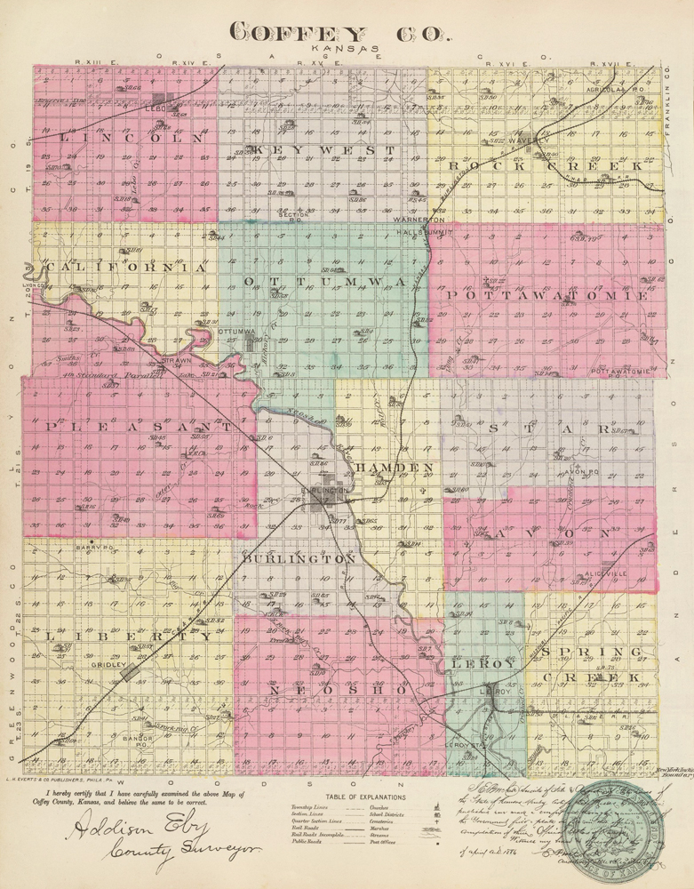
Coffey County, Kansas Map by L.H. Everts & Co., 1887
©Kathy Alexander/Legends of Kansas, updated February 2026.
Also See:
Sources:
Blackmar, Frank W.; Kansas: A Cyclopedia of State History, Vol I; Standard Publishing Company, Chicago, IL 1912.
Cutler, William G; History of Kansas; A. T. Andreas, Chicago, IL, 1883.
Kansas Post Office History