
John Redmond Reservoir near Burlington, Kansas, by Kathy Alexander.
John Redmond Reservoir lies in a broad, flat valley along the eastern edges of the gently rolling Flint Hills. The Flint Hills are a bluestem grass region of natural scenic beauty and the largest remaining expanse of the original native tallgrass prairie in the nation. The man-made lake was created and managed by the U.S. Army Corps of Engineers for flood control, recreation, water supply, and wildlife management. It borders the Flint Hills National Wildlife Refuge to the northwest. This 18,463-acre refuge provides diverse habitat, a haven for a wide array of mammals, birds, reptiles, amphibians, and insects. In addition, the Corps of Engineers has licensed the Kansas Department of Wildlife, Parks, and Tourism to manage 1,637 acres on the reservoir’s southwest shore as the Otter Creek Wildlife Area. The Otter Creek Area occupies 240 acres and is open for off-road vehicle use. The Corps also manages the Hickory Creek Trail on the reservoir’s north shore, which is open to hiking, horseback riding, and mountain biking. The entire reservoir lies within Coffey County.
The Neosho River Valley flooded more than 50 times in the 30 years leading up to 1950, when the U.S. Congress authorized the flood control project that later became John Redmond Dam and Reservoir. It was authorized and awaiting construction during the Great Flood of 1951, which inundated downtown Burlington and Strawn, where some locations had floodwater 30 feet deep.
Originally, Congress authorized the project under the Flood Control Act of 1950, naming it the Strawn Dam in reference to the town of Strawn, which was located at the site of the current reservoir. When the dam was constructed, Strawn was relocated six miles east to higher ground and renamed New Strawn. In 1958, Congress renamed the project the John Redmond Dam and Reservoir to honor the late John Redmond, the publisher of the Burlington Daily Republican, who was a long-time advocate for flood control and water conservation along the Neosho River. John Redmond passed away in 1953.
The design and construction of the project were managed by the Tulsa District of the U.S. Army Corps of Engineers, at a total cost of $29,264,000. Construction began on June 18, 1959, and the dam was put into service on November 17, 1964, several weeks before its final completion, in order to protect the Neosho River Valley from anticipated winter and spring floods.
The reservoir is impounded at its southeastern end by John Redmond Dam. The Neosho River is both the reservoir’s primary inflow from the northwest and outflow to the southeast. Smaller tributaries include Hickory Creek and Kennedy Creek from the north, as well as Buffalo Creek and Otter Creek from the west.
During the Great Flood of 1993, floodwaters reached the top of the dam’s release gates. The reservoir reached capacity in July 1993, which required the first release from the spillway.
There are several settlements on or near the reservoir. The largest, Burlington, lies about two miles southeast of the dam on the Neosho River. New Strawn is located immediately east of the reservoir at the northeast end of the dam. Ottumwa, an unincorporated community, sits on the reservoir’s north shore.
The surface area, surface elevation, and water volume of the reservoir fluctuate with inflows and local climatic conditions. When full, John Redmond Reservoir has an approximate surface area of 9,400 acres, a surface elevation of 1,041 feet, and a volume of 67,302 acre-feet. When filled to maximum capacity, it has a surface elevation of 1,073 feet and a volume of 755,330 acre-feet.
The Tulsa District of the U.S. Army Corps of Engineers manages John Redmond Dam and Reservoir for flood control, recreation, water quality control, and water supply. The Corps oversees recreational activities both on the reservoir surface and in the parks around it.
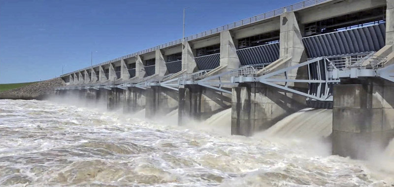
John Redmon Dam.
John Redmond Reservoir serves as a reserve water supply for the Wolf Creek Nuclear Power Generating Station, located five miles east. During construction of the facility, a second reservoir, Coffey County Lake, was created to serve as a water source, eliminating the need for a cooling tower. The water level of the Lake is kept above a mandatory level by pumping water from John Redmond when needed.
The Corps of Engineers manages three parks at the reservoir for tent or RV camping: Dam Site Park, Riverside East Park, and Riverside West Park. Dam Site Park is located at the northeast end of the dam on the reservoir’s eastern shore. Riverside East Park and Riverside West Park lie immediately below the dam on both sides of the Neosho River. Both Dam Site and Riverside West host boat ramps and include hiking trails. All three parks include picnic tables, cookers, sanitation facilities, and parking.
U.S. Route 75 runs generally north-south east of the reservoir. 12th Road, a paved county road, runs east-west south of the reservoir. Another paved county road, Embankment Road, runs northeast-southwest along the top of the dam.
The reservoir is open for sport fishing, and hunting is allowed, with restrictions, on the public land around the reservoir, including in the Flint Hills Refuge. Fish species resident in the reservoir include channel and flathead catfish, crappie, walleye, and white bass. One invasive species, the zebra mussel, is also present. Game animals living on land around the reservoir include bobwhite quail, cottontail rabbits, mourning doves, prairie chickens, squirrels, turkeys, and whitetail deer.
Bird-Watching is also popular as the lake is home to 291 bird species. The reservoir lies on an important migratory route for ducks, geese, and other bird species. Large flocks of ducks, as well as snow and blue geese, move through the Neosho River Valley in the spring and fall, and the Flint Hills contain the largest single concentration of greater prairie chickens in the United States.
A bird-watching blind is available at the John Redmond Reservoir East Camping area, and various groups and organizations have been formed for serious bird-watchers.
Consisting of 9,400 acres, the John Redmond Reservoir offers a variety of the finest in water recreation, including boating, fishing, and other water sports. Camping, day use, boating, hiking, sightseeing, and fishing are activities available to the public. The Otter Creek off-road vehicle area and the Hickory Creek trail are specialized activity areas. The Otter Creek off-road area offers 240 acres of all-terrain use for dirt bikes and ATV users.
Information can be obtained by visiting the John Redmond Lake Office located at the east end of the dam. Information can be obtained by visiting the John Redmond Lake Office located at the east end of the dam.
Food, bait, tackle, and fuel are available nearby in Burlington, Kansas.
John Redmond Reservoir is located on the Neosho River, three miles north and one mile west of Burlington.
John Redmond Lake Office
1565 Embankment Road SW
Burlington, KS 66839
620-364-8613
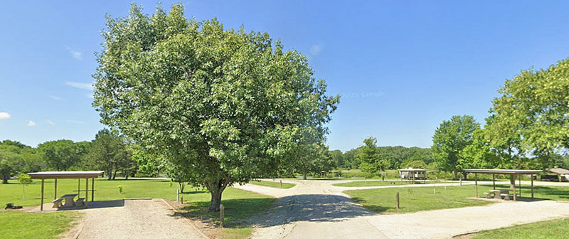
John Redmond Campsites, courtesy of Google Maps.
©Kathy Alexander/Legends of Kansas, updated February 2026.
Also See:
Sources: