By Diana Staresinic-Deane.
Traveling over the prairie without a road, save a dim wagon track in the grass, through a county as yet unnamed and over the divide between two nameless creeks, we were all watching to see the Neosho timber. — John Van Gundy, Reminiscences of Frontier Life on the Upper Neosho in 1855 and 1856
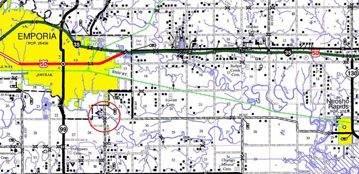
“Do you think this might be it?” I asked my husband, Jim, as we drove down Road M. We were searching for the remnants of Columbia, a ghost town documented in Daniel C. Fitzgerald’s Ghost Towns of Kansas: 6. Other than the wooded area along the Cottonwood River, which we were about to cross, we were surrounded by nothing but acres and acres of farmland. But if we had correctly interpreted the various descriptions from early Lyon County residents, then we were about to drive past the ghost of one of the county’s oldest towns.
In the mid-1800s, the only white residents in this part of the country were (supposedly) missionaries and government-licensed traders along the wagon trails. Lyon County’s earliest settlers were no different. The first official U.S. citizen to find his way to the area was Charles Withington, who in 1854 set up shop at what would become the town of Allen on the Santa Fe Trail, which rolled through the northern portion of the county. The next major stop along the trail was Council Grove, where an entire government settlement of shops and services existed as a last stop for travelers on their way to New Mexico. The rest of the area’s inhabitants lived on the Kaw or Sac and Fox reservations.
Then the Kansas-Nebraska Act changed everything.
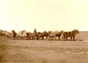
Overland Freighter by W.D. Harper.
As the Kansas border was opened up to white settlers, Withington and some of Council Groves’s merchants and missionaries – T.S. Huffaker, Seth M. Hays, Goodson Simcock, and Christopher Columbia (and some sources say William T. Harris) – saw an opportunity to claim their own land and set up shop in present-day Lyon County, which was then two counties: Breckenridge County to the north, and Madison County to the south. (The dividing line for anyone familiar with Emporia was Logan Avenue, just a block north of the David Traylor Zoo.)
In 1855, these men established a small cluster of buildings near a river crossing at what is now Section 23 in Township 19S, Range 11E, including lodgings, supplies, and a blacksmith shop. Only the sections weren’t clearly marked back then because they weren’t officially surveyed until 1857. Columbia was officially in Madison County, which would only exist for a few more years.
“The best that one could do then was to guess off a quarter section of land in a desirable spot and mark it out large enough to be sure of a good portion of the land embraced in the description. Even then, it would be likely to happen that the claimant’s cabin would finally be in one section and his well in another; or, there might be two or three cabins in the same quarter section.”
— John Van Gundy, Reminiscences of Frontier Life on the Upper Neosho in 1855 and 1856
Most of us native Kansans were programmed early on to associate Kansas’ origins with an anti-slavery mentality. But in 1855, Kansas was more complicated than that, and Lyon County even more so. The people moving into the area represented a variety of political beliefs. The majority of the Council Grove men who set up shop in Columbia were pro-slavery; Seth Hays was himself a slave owner. Like David Van Gundy (father of John Van Gundy), others were Constitutionalist who believed that states and territories had the right to make their own decisions about such things. Still, others were Free-Staters or Free-Soilers, who believed that there was no need to extend slavery rights to new territories. Still, others, like Joel Haworth, whose home was part of the underground railroad a few miles up the Cottonwood River from Columbia, were abolitionists who believed slavery should be eliminated from all U.S. states and territories.
Imagine all of these different people homesteading next to each other, depending on each other, out on the open prairie.
Thousands of pro-slavery men from Missouri crossed the border into Kansas to stuff the ballot boxes.
1855 was also the Bogus Legislature year when pro-slavery Missourians sneaked into Kansas to cast their votes to make the Kansas territory slavery-friendly. At this time, Columbia was the county seat for Madison County, and a pro-slavery leadership was elected for the county and its representation to Topeka.
Breckenridge and Madison County residents maintained this uneasy, unsettled existence, which finally came to a head on September 14, 1856, when abolitionists—including John E. Cook, who would hang alongside John Brown at Harper’s Ferry — launched an attack on settlements along the Neosho River. Mrs. Sarah Van Gundy Carver, daughter of one of the area’s earliest settlers, died that night, and several stores, including Withington’s, were robbed and looted. Many of Neosho Rapids’ residents — 78 families, according to the documentary A History of North Lyon County — headed east for safety. Only five families returned and found that new settlers had already jumped their claims.
By the end of 1856, the men of Columbia were ready to go back to Council Grove, where Seth Hays operated a saloon known as The Hays House and jointly operated The Last Chance store with Simcock. The stores in Colombia were turned over to Dr. Stiggers.
John Van Gundy described his first impression of Columbia at that time:
“We traveled in a westerly direction until we came to a wagon road turning south and soon came in sight of a log house with a lean-to on the south.” According to Van Gundy, Stiggers was operating a dry goods store, a drug store, a grocery, and a liquor store all under the same roof just north of the river ford. As one of only a few doctors in the area, he was also busy giving medical attention to patients. Food was cooked in the lean-to.
As the population of Breckenridge and Madison counties grew, so did the demand for the U.S. Postal Service. Columbia served as an official post office. By 1857, Jefferson S. Pigman, who took over the store in Columbia after his own store in Neosho Rapids was looted during the abolitionist raid a few months earlier, was dispersing mail from Westport, Missouri, down the Santa Fe Trail to Council Grove, where it was finally delivered to Columbia. These routes could be dangerous. In her Early History of Lyon County, Kansas, Lucinda Jones writes about freighter Tom Evans and his brother, who saw “gruesome sights,” including a “group of eight men hanging to a little oak tree, horse thieves.”
I can’t help but wonder if this tree once stood on land now in someone’s front yard.
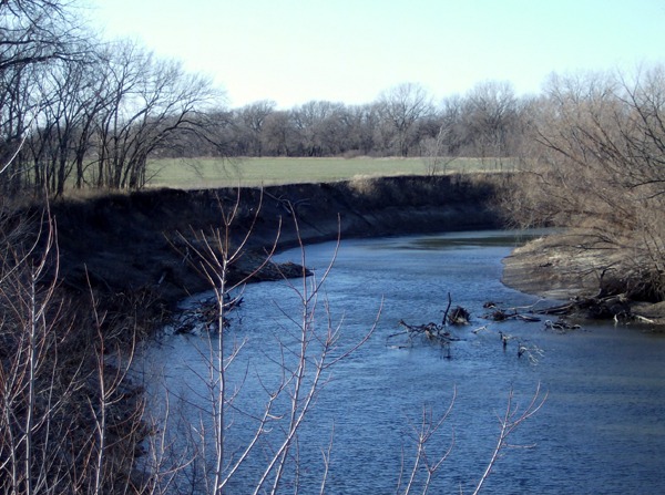
The Cottonwood River today, near the site of the original Columbia settlement. The river has shifted many times since Columbia’s townsite was established in 1855.
Despite there being an established mail system, the city of Emporia, with its decisively anti-slavery leanings, did not approve. “This would not do the wide-awake Emporians at all,” Jacob Stotler wrote in his Annals of Emporia and Lyon County. “They hated everything pro-slavery, and instead of patronizing this route, they took steps to have their mail sent by way of Lawrence. They had box 500 in Lawrence, from whence private hands brought the mail. A weekly hack line to that city was established, leaving here every Monday and returning every Friday. It took four full days to make the round trip and one day to rest at Lawrence.
Pigman moved on, and John Fowler, whose lands were near the Columbia settlement, served as postmaster until the official post office was moved to Emporia. Fowler went back to farming, and H.W. Fink became Emporia’s first postmaster.
Around the time that the post office at Columbia was facing its demise, John Street, a surveyor for the General Land Office, made his way through Township 19S Range 11E, completing the survey between March 17 and April 1, 1857. His painstakingly detailed notes record the land, the vegetation, and the settlements he encountered as he and his crew moved up and down each section line.
Of Columbia, he wrote: “The Cottonwood runs through the southern part of this Township, is very winding in its curves…the town of Columbia was laid out about one year ago on the left bank of the Cottonwood River. I could not find any of the corners; therefore, I did not take any notice of the… lines with the town… it now contains several buildings, a store, a blacksmith, and dwellings, a good ford at this place.

Section 23, from John Street’s 1857 GLO Survey Map. Notice the only roads going through Columbia are the trail road to
Council Grove (the upper road moving northwest) and the road to Diamond Springs (the lower road moving northeast)
According to J.S. Pigman’s obituary, which ran in the Emporia Gazette on February 9, 1911, “the town never grew beyond the proportions of a log store and post office combined, a double log dwelling house, a blacksmith shop, and perhaps one or two other buildings. A family named Whitaker lived in half of the dwelling house part of the time, and the other half was occupied by its owner and his family, the late Reason Snow, a pioneer known to most of the early settlers in this community.”
Daniel C. Fitzgerald, a Kansas ghost-town historian, argued that this marked the end of Columbia. “By late summer 1857, what was left of the town had moved to the present location of Columbia,” he wrote in Ghost Towns of Kansas: 6. While the cluster of shops may not have continued, a new rural community did grow in this area. Historians have suggested that by 1858, nothing remained of Columbia, yet new settlers were moving into the area. In 1868, shortly after their marriage, William and Jane Willis claimed their 80 acres, most of which was situated immediately south of the Cottonwood River and the Columbia Bridge, formerly the Columbia Ford. It also included a pinch of land across the river: the former Columbia townsite.
“There were no improvements on the land, so they found and moved into an abandoned log cabin on this [the north] side of the river, on the old Columbia townsite. This cabin had no doors, windows, or floor and had been used to house cattle. When the elder Mrs. Willis saw this abode, she broke down. She cried, for the comfortable, cozy house she left in Ohio was dear to her” – from “The Willis Golden Anniversary” announcement, Emporia Gazette, January 23, 1918.
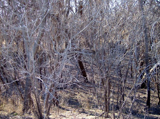
The Cottonwood River has shifted its course many times since Columbia was first settled in 1855. Just a few hundred yards north of where the Cottonwood River flows, timber fills in an older riverbed. This may have been part of the active river when Columbia was still populated.
This is also not the end of Columbia’s story, which is astonishing considering how many times the area has flooded. According to Laura French’s History of Emporia and Lyon County, “Beginning with 1857, engineers in 1926 making a survey…found record of forty-seven more or less destructive floods in Lyon County.” In 1904, an especially severe flood tore the 150-foot three-span iron Columbia bridge from its abutment, causing it to roll into the water.
And yet, the ghost of Columbia persisted. Farmers and county commissioners alike recognized the need for this bridge, a lifeline between Emporia and the rural community. The bridge was rebuilt and reopened the following year, and continued to be referred to as the Columbia Bridge. The newspaper, in its weekly updates of local communities, continued to refer to the area as the Columbia community for decades more.
At last, the name Columbia began to fade. In the late 1940s, the Emporia Gazette began referring to the water crossing as Flat Rocks Bridge. The weekly roundup of community happenings no longer included a listing for Columbia. By the 1960s, the only mention of old Columbia and the Columbia Bridge occurred in the obituaries of old-timers who themselves faded away one by one.
In 1972, Flat Rocks Bridge was declared unsound and closed. The old 1905 bridge was never meant to handle the heavy equipment crossing it for nearly seven decades. It was replaced with the current structure in 1989.
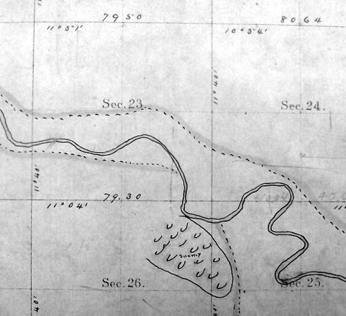
Section 23, as depicted in Lyon County’s first official plat map, 1874. Notice how wide the riverbed appears and that the river is in a very different place when compared to John Street’s GLO map from 1857. The squiggles immediately south of the river indicate a swamp.
Unfortunately, despite all the available information, it is still not entirely clear where Columbia’s settlement was located. Several early maps of Kansas, like this 1856 map (to the right) drawn by General Land Agents out of Lawrence, Kansas, mistakenly locate Columbia at the confluence of the Cottonwood and Neosho Rivers, which is where Neosho Rapids (well, depending on the year, it could have been listed as Florence, Italia, or Neosho City) was and is located. In addition, the ever-shifting Cottonwood River has, with tremendous persistence, carved its way farther south with each flood, of which we know there have been many. The first official plat map used by Lyon County, beginning in 1874, shows the river in a totally different location from John Street’s GLO survey map.
Because John Street’s task was to survey the section lines and not to mark every single tree, rock, and water source between the lines, the location where the river flowed between the section lines is not necessarily exact. Was the town drawn in at its exact location, or only in respect to the river?
Land records were also not helpful. Although we know U.S. citizens have settled in Section 23 since 1855, the county’s land records do not begin until 1860, when the land was patented. Most of the early land records use the section lines as official boundaries–except in relation to the river. All too often, the river is cited as the boundary, but an ever-shifting river means ever-shifting boundaries. The 1878 Lyon County Atlas, the 1918 Atlas, and Google Maps show further movement regarding the Cottonwood River.
After days of studying maps, anecdotal notes, and aerial satellite images, it became apparent that the most likely location of one of the county’s first towns and first fords on the Cottonwood River is now a big, empty field just north of the trees that have filled in the old, abandoned river channel.

Likely Columbia Townsite.
So ends the story of Columbia. A town that once had the potential to influence the land, its people, and the law is now an empty field, with not even a whisper of acknowledgment on modern maps. And yet, without Columbia, Lyon County’s history would be different; Lyon County would be different. Despite its short lifespan, it is an important part of Kansas’s story.
©Diana Staresinic-Deane, Unearthing Stories on the Prairie, updated May 2026.
 About the Author: Diana Staresinic-Deane is a self-described Kansan-gone-Californian-gone-Kansan. After spending her entire childhood in the same house in Kansas City, Kansas, she headed west to Los Angeles, where she earned a bachelor’s degree from the University of Southern California. Eleven moves later, she was back in Kansas. Though she’s lived in the suburbs, in the heart of one of the country’s biggest cities, in the mountains, and near the ocean, she says it wasn’t until she began to explore the prairies and small towns of Kansas that she really found a home — falling in love with the landscape, the history, and the people. Diana is a writer, collector of local history, and the webmaster of the popular blog, Unearthing Stories on the Prairie.
Also See:
Emporia – Hub of East Central Kansas