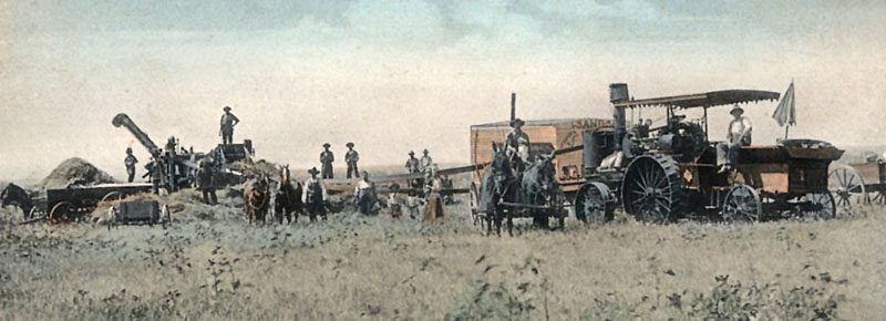
Wheat harvest in Ottawa County, Kansas.
| Town | Post Office Dates | Additional Information |
| Ackley | 1879-1888 | |
| Ada-Hot Hill | 1872-1998 |
Ada, Kansas, is a small town and census-designated place situated on Salt Creek in Fountain Township of northwestern Ottawa County. It is also an extinct town as its post office closed years ago. This place was initially called Hot Hill when a post office was established on August 27, 1872. However, the name changed about a month later to Ada on September 26, 1872. As of the 2020 census, the population was 86. |
| Ailanthus | 1872-1878 1881-1882 |
Ailanthus was a settlement located on the south fork of the Solomon River in the northwestern part of Ottawa County, five miles from Minneapolis, the county seat. |
| Bluffton | 1872-1886 | Bluffton was a rural district located on the Saline River, in the southwestern part of Ottawa County. In 1878, it was on the stagecoach line to Salina and Lincoln, from which the mail was delivered to W.H. Wheeler, the postmaster. It was 14 miles from Minneapolis, the county seat, 15 from Brookville on the Kansas Pacific Railroad, the nearest station, and 148 from Topeka. |
| Braid | 1885-1890 | |
| Caledonia | 1876-1885 | Caledonia was a small settlement formed in 1876 in the southwestern part of Ottawa County. In 1878, it was on the proposed line of the Solomon Valley Railroad. It was on the stagecoach line to Solomon City, from which its daily mail was delivered to Mr. Frost, the postmaster. Solomon City, on the Kansas Pacific Railway, was its nearest shipping point, from which it exported grain, pork, flax, and produce. It was eight miles from Minneapolis, the county seat, and about 120 miles from Topeka. |
| Chapman’s Dugout | NA | When the Stephen B. Chapman family moved from Douglas County, Kansas, to Ottawa County, Kansas, in 1863, they settled along the Solomon River. They built a dugout consisting of a single room that measured 14 by 16 feet. During this time, relations between the settlers and the Native Americans were tense, leading to frequent raids and disturbances. Soon, many settlers sought refuge in the Chapman Dugout, with as many as 52 men, women, and children taking shelter. It continued to be used until Fort Solomon was built in 1863, about a mile to the north. |
| Churchill | 1869-1886 | Settled in 1866, Churchill was a small settlement on the Saline River, in the southwestern part of Ottawa County. Thomas Bartlett Sears came to Kansas after service in the Civil War. He had a post office in his home, which he named Churchill. In 1878, it was on the stagecoach line to Saline and Lincoln, from which it received its daily mail. At that time, the population was 25. It was 14 miles from Brookville on the Kansas Pacific Railroad, its nearest shipping point, from which it exported grain, wood, and hogs. It was 16 miles from Minneapolis, the county seat, and 151 miles from Topeka. When the post office closed, it was moved to Tescot. |
| Coal Creek | 1866-1884 | Coal Creek was a small station five miles southeast of Bennington, on the Solomon Valley Railroad, a branch of the Kansas Pacific Railroad. The name was derived from the supposed existence of coal in its vicinity. It was located on the Solomon River in the southeastern part of Ottawa County, 20 miles from the county seat of Minneapolis, and 15 miles from Solomon City. After the post office closed, it was moved to Georgetown. |
| Culver | 1873-1984 | Culver, Kansas, is a small incorporated town located in Culver Township, Saline River, in southwest Ottawa County. As of the 2020 census, the city’s population was 114, and it had a total area of 0.15 square miles, all of which is land. |
| Fort Solomon | NA | Fort Solomon was built in Ottawa County, Kansas, in the early part of 1864, when Indians became very troublesome. Their raids were frequent in adjoining counties, and six settlers in Saline, Ottawa, and Mitchell counties lost their lives. In the late 1860s, the Indian raids ceased, and Fort Solomon was abandoned. By 1871, the fort had only a few cabins left. Eventually, the fort’s structures collapsed due to a lack of maintenance. |
| Georgetown | 1879-1885 | Georgetown was founded by George Carbaugh, who was also a player in the development of Niles. Georgetown was located just a half mile away from Niles, resulting in considerable competition between the two. The post office moved from Coal Creek when it was established in 1879. Later, Niles won out, and Carbaugh relocated Georgetown to the Niles site instead. After the post office closed, it was moved to Verdi. |
| Grove | 1870-1885 | Grove was settled in 1865 on Pipe Creek in Logan Township, in the northern part of Ottawa County. In 1878, the population was approximately 200. The community had a Methodist Church and was located on the stagecoach line to Minneapolis and Clay Center, from which its mail was delivered daily to John Gibbs, the postmaster. It was eight miles from Minneapolis, the county seat; 33 miles from Solomon City, located on the Kansas Pacific Railway, the nearest shipping point; and 138 miles from Topeka. |
| Lamar | 1872-1912 1913-1958 |
Settled in 1870, Lamar was an incorporated village on Pipe Creek in Sherman Township in the northern part of Ottawa County. In 1878, it had a teacher, a Wesleyan preacher, a general store, a shoemaker, a doctor, and a population of approximately 300. In 1878, Clay Center, 32 miles distant, was the nearest shipping point from which livestock was exported. At that time, it was on the stagecoach line to Minneapolis and Clay Center tri-weekly, from which the mail was delivered to Mrs. Louisa M. McConnell, postmistress. In the following decades, its population decreased, and by 1910, it had a population of 50, at which time it had a money order post office with one rural route. It was 17 miles northeast of Minneapolis, the county seat, and ten miles north of Wells, the nearest railway station. |
| Lindsey-Ayersburgh | 1864-1896 1899-1942 |
First called Ayersburgh, this place was settled in 1864 on the Solomon River and Lindsey Creek, in Concord township in the central part of Ottawa County. The town’s name was changed from Ayersburgh to Lindsey on July 7, 1868. By 1910, it was a station on the Union Pacific Railroad, featuring express and telegraph offices, a money order post office, and served as a shipping point for agricultural products and livestock, with a population of 28. It was two miles from Minneapolis, the county seat, and 130 miles from Topeka. |
| Melville | 1878-1890 | |
| Nile-Nilesville | 1885-1974 |
This town was initially called Nilesville when a post office was established in Lincoln Township near the county line in 1885. The town’s name changed from Nilesville to Niles on August 25, 1887. In 1910, it was located on the Union Pacific Railroad, which at the time had a bank, telegraph, and express offices, a money order post office with one rural route, and all the main lines of business activity, with a population of 200. Niles is an extinct town today as its post office closed decades ago. However, it still displays a number of homes, a grain elevator, and an active railroad. It is 18 miles southeast of Minneapolis, the county seat. |
| Ohio Grove | 1873-1879 | After the post office closed, it was moved to Crown Point. |
| Penquite | 1886-1895 | |
| Pipe Creek | 1874-1898 | Settled in 1875, Pipe Creek was located in Logan Township, in the northern part of Ottawa County. In 1878, the community had a doctor, a schoolteacher, a blacksmith, two carpenters, a Methodist Church, a public school, and a population of approximately 20. It received its mail by carrier on a weekly basis, which was delivered to Edwin Colton, the postmaster. Shipments of grain were made from Concordia and Clay Center. It was 14 miles from Minneapolis, the county seat. |
| Ritsman | 1880-1881 | |
| Sumnerville | 1867-1895 | Sumnerville was located on the Solomon River, on the mail route between Solomon City and Beloit, in the northern part of Ottawa County. Captain A.D. Pierce landed a post office in June 1867, and the place was called Sumnerville. The place was named for Charles Sumner, whose famous speech in the Senate on “The Crime Against Kansas” provoked the assault on his life by Representative Brooks of South Carolina. It was 14 miles from Minneapolis, the county seat, 25 miles from Salina, the nearest station, and 135 miles from Topeka, the state capital. Its mail was delivered daily to John D. Henry, the postmaster. |
| Verdi | 1885-1935 | Verdi was a station on the Union Pacific Railroad in Buckeye Township of Ottawa County. In 1910, it had an express office, a money order post office, and a population of 65. It was 15 miles southeast of Minneapolis, the county seat. |
| Vine-Vine Creek | 1879-1932 | Irish immigrants from County Cork, Ireland, settled in Vine, Kansas. This town was initially called Vine Creek when a post office was established. The name changed to Vine on July 18, 1894. In 1888, a rail line of the Chicago, Kansas and Western Railroad opened from Manchester, Kansas, in the east to Barnard in the west, a 43-mile line, with a stop at Vine Creek. The Atchison, Topeka & Santa Fe Railroad acquired the railroad in 1901. In 1910, it was located on the Atchison, Topeka & Santa Fe Railroad. At that time, it had a money order post office, telegraph office, and express office, and a population of 50. The railroad name was Vine Creek. It was 18 miles east of Minneapolis, the county seat. An application was filed in 1983 to abandon the railroad line. |
| Wells-Poe | 1888-1996 | Located in Grant Township, this place was initially called Poe when a post office was established. The name changed from Poe to Wells on October 26, 1892. In 1910, it was a station on the Atchison, Topeka & Santa Fe Railroad, had a money order post office with one rural route, an express office, and a population of 42. Wells is a ghost town today, still displaying several old business buildings, an active church, and numerous homes. It is nine miles east of Minneapolis, the county seat. |
| Widerange | 1882-1904 | |
| Windsor | 1869-1887 | Windsor was a small settlement on the Saline River in Culver Township, in the southwestern portion of Ottawa County. It was first settled in 1864. The Saline River provided water power for several sawmills in the neighborhood. In 1878, it had a common school and was on the stagecoach line to Salina and Lincoln, from which the mail was delivered twice daily to Mrs. Callie E. Berg, the postmistress. The town exported wheat, corn, and hogs. It was 14 miles from Minneapolis, the county seat. |
| Yale | 1873-1887 | Yale was a post office located in the northeastern part of Ottawa County, 16 miles from Minneapolis, the county seat, and 25 miles from Solomon City, the nearest shipping point on the Kansas Pacific Railroad, and 130 miles from Topeka. Hogs and grain were its chief exports. |
| York | 1880-1886 |
©Kathy Alexander/Legends of Kansas, updated July 2025.
Also See:
Sources:
1878 Gazetteer and Business Directory
Blackmar, Frank W.; Kansas: A Cyclopedia of State History, Vol I; Standard Publishing Company, Chicago, IL 1912.
Cutler, William; History of the State of Kansas, A.T. Andreas, Chicago, IL, 1883.
Kansas Post Office History


