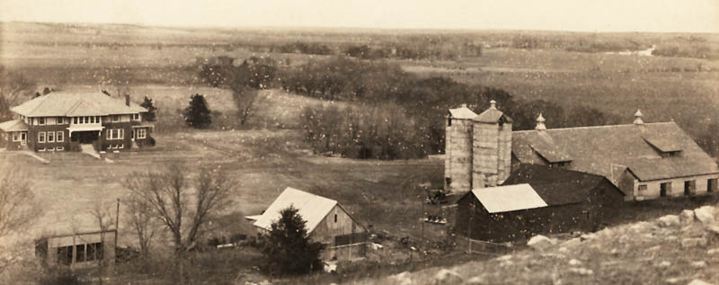
Avery Farm in Clay County, Kansas, 1900.
| Town | Post Office Dates | Additional Information |
| Athelstane | 1872-1875 1878-1898 |
A small place located in the southern central part of Clay County, 13 miles from Clay Center, the county seat. |
| Bateham | 1875-1902 | Settled in 1874, this was a small hamlet in Republican Township near the county’s southern boundary, approximately 13 miles due south of Clay Center. Wakefield was the nearest railroad station. In 1878, it had a Methodist Episcopal Church, a primary school, a livery, a shoemaker, a harness maker, a carpenter, and a population of 50. The community shipped grain and livestock and was on the stagecoach line to Wakefield, from which mail was delivered semi-weekly to S. Shivers, the postmaster. In 1885, it had Methodist Episcopal and Christian Churches, a public school, a justice of the peace, a constable, a wagonmaker, a land and loan agent, a carpenter, a lawyer, and a population of 75. At that time, the mail was delivered by stagecoach from Junction City, 30 miles southeast, to Samuel Shivers, the postmaster. |
| Broughton/Rose Vale/Springfield | 1869-1966 |
The name changed from Rose Vale to Springfield on September 10, 1885. The name changed back to Rose Vale on October 24, 1887. The name changed from Rose Vale to Broughton on August 17, 1888. In 1910, it was a thriving little town in Clay Center Township, on the Chicago, Rock Island & Pacific, and the Union Pacific Railroads, a few miles southeast of Clay Center. At that time, it had a money-order post office with two rural delivery routes, a telegraph, a telephone, and an express service, a hotel, some good general stores, good public schools, and a population of 160. It was the busiest little town between Clay Center and Manhattan. It was razed in 1966 during the construction of Milford Lake. |
| Carter Creek | 1872 1874-1883 |
This settlement was formed in March 1869 on the stream from which it takes its name in the northeast corner of Clay County. In 1878, it had a flour mill, a Justice of the Peace, shipped grain and country produce from Greenleaf, and had a population of 25. It was on the stagecoach line to Greenleaf and Clay Center, from which the mail was delivered daily to James McCurdy, postmaster. The post office moved to Fact when it closed in 1883. It was 16 miles from Clay Center, the county seat, and 120 miles from Topeka. |
| Chapmanville | 1879-1882 | The post office moved to Idana. |
| Charity | 1882-1893 | A small place 14 miles west of Clay Center, the county seat, and its nearest railroad point. The closest bank was in Miltonvale. In 1885, its mail was delivered semi-weekly by stagecoach to R.L. Bagby, postmaster, grocer, and justice of the peace. |
| Deep Creek | 1870-1876 | A small place located in the extreme east of Clay County, ten miles from Clay Centre, the county seat. |
| Delavan | 1872-1880 | A country post office located in the northeastern part of Clay County, six miles from Clay Center, the county seat and nearest shipping point, and 110 miles from Topeka. It was on the stagecoach line to Waterville and Clay Center, from which the mail was delivered tri-weekly to A. Lapham, the postmaster. |
| Eagle Bend | 1871-1872 | |
| Exeter | 1871-1906 | An inland hamlet about ten miles southwest of Clay Center, the county seat and most convenient railroad station. In 1878, it was on the stagecoach line to Clay Center and Abilene, from which semi-weekly mail was delivered to A.C. Butler, the postmaster. In 1885, it had a district school, Methodist and Congregational Churches, and was on the stagecoach line to Clay Center and Abilene, from which the mail was delivered tri-weekly. |
| Fact | 1883-1903 | The post office moved from Carter Creek. A small hamlet in the northeast corner of the county, it was about 15 miles from Clay Center and eight miles from Palmer, the nearest railroad station. In 1885, it had Methodist Episcopal and Congregational Churches, a public school, and mail was delivered by stagecoach from Center tri-weekly to T.S. Lloyd, the postmaster. The population in 1910 was 26. |
| Fancy Creek | 1870-1901 | Settled in 1860, this farming settlement was located on the stream from which it takes its name in the northeastern part of Clay County, 12 miles from Clay Center, the county seat and nearest shipping point, and 116 miles from Topeka. In 1878, it had two churches (Baptist and Methodist), a district school, exported grain, and a population of 25. It was on the stagecoach line to Clay Center and Waterville, from which mail was delivered daily to H.H. Jenkins, the postmaster. By 1885, its closest shipping point was Green, five miles south, from which grain and livestock were shipped. |
| Fayettville | 1869-1871 | |
| Gatesville | 1862-1888 | A small settlement on the Republican River in southeastern Clay County, it was 10 miles from Clay Center, the county seat, and 5 miles from Wakefield. In 1878, it had a Methodist preacher, a physician, and mail was delivered daily to Joseph Bradbury, the postmaster. By 1885, it was a flag station on the Union Pacific Railroad. |
| Goshen | 1883-1884 | |
| Hebron | 1873-1882 | A post office in the western part of Clay County, it was miles from Clay Center, the county seat and nearest shipping point, and 112 from Topeka. In 1878, it was delivered by mail daily to S.H. Mundy, the postmaster. |
| Idana | 1882-1980 | The post office moved from Chapmanville. The name Idana was a combination of the names of two sisters: Ida Howland and Anna Broughton. It was located in Five Creeks Township on the Union Pacific Railroad, seven miles west of Clay Center. The Presbyterian Church, still the center of much activity in town, was built in 1889. The community has a few vacant business buildings and several homes. |
| Idylwild | 1897-1901 | A hamlet located 11 miles north of Clay Center. The population in 1910 was 15. |
| Iwacura | 1882-1894 | A country post office in Clay County, it was 18 miles northwest of Clay Center, the county seat, and 12 miles south of Clifton, its nearest banking and shipping point, from which its mail was delivered semi-weekly by stagecoach to James H. Geist, postmaster. |
| Ladysmith | 1900-1906 | A hamlet ten miles southwest of Clay Center. In 1910, it had a general store and a population of 20. The site is along Kiowa Road today. |
| Leopaa | 1875-1882 | A settlement established in 1870 in the northeast corner of Clay County, 16 miles from Clay Center, the county seat, and 12 miles from Greenleaf, the nearest shipping point. In 1878, it chiefly exported grain and hogs and was on the stagecoach line to May Day and Kimeo, from which the mail was delivered daily to Benjamin Watton, the postmaster. |
| Lima-Wyoming Valley | 1865-1873 | The name changed from Wyoming Valley to Lima on January 15, 1867. |
| Lovejoy | 1873-1876 | The post office moved to Industry. |
| Lund | 1885-1886 | |
| Madura | 1869-1871 | It was two miles south of Wakefield. |
| Maple Grove | 1873 | The post office was open for less than six months. |
| Mellon Springs | 1876-1877 | A small place in Clay County, 18 miles northwest of Clay Center, the county seat. |
| Mulberry | 1868-1869 | The post office moved to Riverdale. |
| New Grant | 1872 | The post office was only open for about seven months. |
| Oak Hill | 1871-1995 | Oak Hill is a small town in Oakland Township on Chapman Creek, 15 miles southwest of Clay Center. |
| Oberg | 1897-1899 | The post office moved to Oscar. |
| Oscar | 1899-1901 | The post office moved from Oberg. The hamlet was located 12 miles north of Clay Center. In 1910, its population was 15. |
| Otter Creek | 1869-1878 | A small settlement on the Republican River in the central part of Clay County, six miles from Clay Center, the county seat, and 110 miles from Topeka. |
| Peach Grove | 1872-1885 | A small settlement on Fancy Creek in the northeastern part of Clay County, 14 miles from Clay Center, is the county seat and nearest shipping point. In 1878, it was on the stagecoach line to Greenleaf and Clay Center, from which mail was delivered daily to George Winsworth, the postmaster. |
| Powellsburgh | 1872-1881 | A post office in Highland Township, near the center of the eastern line of Clay County. It was seven miles east of Clay Center, the nearest railroad point. The post office moved to Green when it closed. |
| Republican City-Five Creeks | 1868-1875 | The name changed from Five Creeks to Republican City on May 12, 1869. |
| Smithville | 1873-1874 | The post office was only open for about five months. |
| Stitt | 1885-1887 | |
| Tabor | 1873-1887 | In Bloom Township, in northwestern Clay County, it was about nine miles from Clay Center, the county seat and nearest railroad station. |
| Uniondale | 1899-1902 | |
| Vining-Riverdale-Lookout | 1869-1955 | Vining, Kansas, is located in Clay and Washington Counties on the Republican River in the northeastern part of the state. This community was originally named Lookout upon its establishment, was later renamed Riverdale, and was finally renamed Vining. |
©Kathy Alexander/Legends of Kansas, updated January 2026.
Also See:
Sources:
1878 Kansas State Official Gazetteer and Business Directory, R.L. Polk & Company.
1884-1885 Kansas State Official Gazetteer and Business Directory, R. L. Polk & Company.
Blackmar, Frank W.; Kansas: A Cyclopedia of State History, Vol I; Standard Publishing Company, Chicago, IL 1912.
Cutler, William G.; History of Kansas; A.T. Andreas, Chicago, IL, 1883.
Kansas Post Office History
Wikipedia


