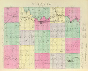
Extinct Towns:
More Extinct Towns:
| Town | Post Office Dates | Additional Information |
| Alva | 1871-1878 | The post office moved to Jamestown. |
| Arion | 1870-1872 1875-1883 |
|
| Beaver Creek | 1871-1877 | |
| Carmel | 1873-1886 1887-1894 |
|
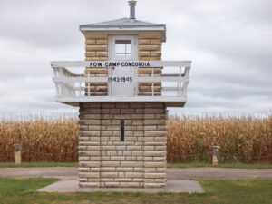
| Camp Concordia | None |
Camp Concordia was a prisoner-of-war (POW) camp in Cloud County, Kansas. It operated from 1943 to 1945 during World War II. |
| Cloud | 1881 | The post office was only open from May to December 1881. |
| Como | 1900-1904 | Como was located about 7.5 miles east of Aurora. |
| Cool | 1881-1887 | |
| Fannie | 1870-1878 | A rural post office on the Smoky Hill River in Empire Township, about 12 miles southeast of Ellsworth. |
| Garley/Wild Rover/Garly | 1873-1876 1876-1881 |
The Garly post office opened on June 3, 1873, and moved to Wild Rover on February 1, 1876. on August 4, 1876, the post office name was changed to Garley. The post office closed for good on January 15, 1881. |
| Gillespie | 1879-1883 | Gillespie was a station on the Atchison, Topeka & Santa Fe Railroad. |
| Graves | 1882-1889 1890-1904 |
Graves was a small town located in the central part of Cloud County, about ten miles south of Concordia. |
| Green Cove | 1879-1881 | |
| Half Way/Cransdale | 1872-1877 1877-1900 |
The town’s name was changed from Cransdale to Half Way on April 11, 1877. |
| Heber | 1881-1904 | Heber, situated near the head of East Pipe Creek, was about 15 miles southeast of Concordia. After its post office closed, mail was received through the post office at Miltonvale. |
| Huscher | 1892-1914 1915-1934 |
Huscher, located in Nelson Township, was six miles southeast of Concordia. It was named for David Huscher, the postmaster. It had a station on the Atchison, Topeka & Santa Fe Railroad and was connected to Concordia by telephone in the early 1900s. By 1910, it had a local trade, did some shipping, and was called home to about 50 people. |
| Hollis-Sunday-Christie | 1885-1960 |
This town was first called Christie for W.J. Christie, the original owner of the townsite. However, when the community received a post office, its name was changed to Sunday. That was also brief, as, after just six months, the town’s name was changed again to Hollis for a pioneer family on August 27, 1885. By 1910, it was a shipping point at the junction of the Chicago, Burlington & Quincy, and Union Pacific Railroads. At that time, it had a money order post office with one rural route, a telegraph office, a good local trade, and a population of 50. In May 1909, a tornado hit Hollis, which caused serious damage and killed several people. Only three buildings escaped damage. The community still displays several homes, silos, and one old business building. Area students attend school in Concordia. |
| Key | 1878-1881 | |
| Lawrenceburg/Salt Creek | 1868-1869 1869-1901 |
The post office name changed from Salt Creek to Lawrenceburg on January 15, 1869. It was named for L.D. or Frank Lawrence, Cloud County pioneers. |
| Macyville/Ten Mile | 1871-1879 1879-1905 |
The town’s name changed from Ten Mile to Macyville on August 22, 1879. Named for George W. Macy, the postmaster. It was located in Summit Township, nine miles southwest of Concordia and about 11 miles northeast of Glasco. The population in 1910 was 62. |
| Malta | 1875-1884 | |
| Meredith | 1871-1910 | Meredith was a small town in Cloud County, about 15 miles south of Concordia and eight miles from Delphos, the nearest shipping point and the post office from which its mail is distributed. The population in 1910 was 78. |
| Minersville | 1877-1899 | Minersville was a small coal mining town located near the northern border of Cloud County. |
| Nelson | 1873-1888 | |
| Oneonta | 1890-1894 | |
| Princeville | 1871-1882 | |
| Red Stone | 1869-1887 | Red Stone was situated on the Central Branch of the Union Pacific Railroad. |
| Rice | 1878-1980 |
Rice is located in Lawrence Township, six miles east of Concordia. In 1910, it was situated on the Missouri Pacific Railroad, had a money order post office with one rural route, some local trade, and a population of 89. Its close proximity to the larger trading center of Concordia inhibited its growth. Today, it continues to have a small population, homes, grain silos, and an old business building. A stone arch bridge, built in 1899 and restored in 1990, can be seen just north of Rice. Students in the area attend school in nearby Concordia. |
| Shirley/Elm Creek | 1868-1878 | A post office was established on January 29, 1868. On January 13, 1869, the name was changed from Elk Creek to Shirley. It closed on May 28, 1878, and moved to Ames. |
| Sibley | 1868-1876 |
Sibley was founded in 1869 and named for Lake Sibley. Both were named for a career soldier named Henry Hopkins Sibley. It was once in the running for the county seat but lost in an 1870 run-off election against Concordia. The lake dried up, the town of Concordia grew up nearby, attracting more settlers, and the |
| St. Joseph | 1878-1882 1885-1901 |
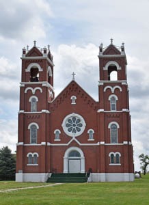
St. Joseph was founded in 1873 by its first Catholic pastor, Father Louis-Marie Mollier. Though little is left of the town today, the beautiful St. Joseph Catholic Church rises above the prairie. |
| Sulphur Spring | 1875-1895 | |
| Warren | 1871-1886 | |
| Welcome | 1884-1885 | |
| Yuma | 1880-1881 1882-1888 1889-1900 |
Yuma was located on the Missouri Pacific Railroad five miles west of Concordia, near the intersections of K-28 and County Road 777. A historical marker remains where the town once stood, populated from 1878 until the 1930s. |
| Zahnville | 1873-1882 | The post office moved to Miltonvale. |
©Kathy Alexander/Legends of Kansas, updated June 2024.
Also See:
Sources:
Blackmar, Frank W.; Kansas: A Cyclopedia of State History, Vol I; Standard Publishing Company, Chicago, IL 1912.
Cutler, William G; History of Kansas; A. T. Andreas, Chicago, IL, 1883.
Kansas Historical Society
Kansapedia
Kansas Travel


