
Smoky Hill River & Monument Rocks in Gove County, Kansas, by Kathy Alexander.
The Smoky Hill River is a 575-mile waterway that runs through Colorado and Kansas and is filled with the lore and legends of Native Americans, explorers, and stagecoach travelers.

Northwest Kansas River Map.
The Indians called this stream the Kansas River, and some early historians did as well.
The earliest known reference to the river was on a 1732 map by French cartographer Jean Baptiste Bourguignon d’Anville, who called it the “River of the Padoucas.” More than 20 years later, a 1758 map called it the “Padoucas River.” During his expedition to visit a Pawnee village, American explorer Zebulon Pike encountered the river in September 1806 and named it the main south branch of the Kansas River. Pike also mentioned that the river was navigable during floods. However, there is no record of it having been navigated other than by the steamboat Excel for one trip in 1854 and by the Gus Linn in 1859, the latter taking a whole day for a round trip between Fort Riley and Junction City. When the river was officially named, it was named for the hills near Abilene and Lindsborg, which were surrounded by isolated buttes that often appeared to be shrouded in hazy smoke. Both the river and the hills soon became known as the Smoky Hills.

Cattle at the Smoky Hill River in Ellsworth County, Kansas, by Alexander Gardner, 1867.
When the Pike’s Peak Gold Rush began in Colorado in 1858, an old Indian trail along the river provided the shortest, fastest route West across Kansas. This soon became known as the Smoky Hill Trail. Beginning in 1865, the trail was the short-lived Butterfield Overland Despatch route. The U.S. Army established several forts along the trail, including Fort Downer, Fort Harker, Fort Hays, Fort Monument, and Fort Wallace, to protect travelers. The Kansas Pacific Railroad was completed in 1870, rendering the Smoky Hill Trail obsolete.
The Smoky Hill River has two main branches, which rise in Colorado. The north fork enters Kansas near the southwest corner of Sherman County, flows about 25 miles East, then turns southeast, cutting across the extreme northeast corner of Wallace County into Logan County. The South Fork is formed by two branches that rise in Kit Carson and Cheyenne Counties of Colorado, about 40 miles from the Kansas line. This branch flows in a generally easterly direction, enters Kansas about the center of the West line of Wallace County, and flows almost due East through that county to unite with the north branch about six miles West of Russell Springs. From this point, the course of the mainstream is almost due East through the counties of Logan, Gove, Trego, Ellis, and Russell, and into Ellsworth County, where it turns southeast, then enters McPherson County. The river here makes a sharp curve to the north. It enters Saline County, flowing as far north as the town of Salina and deviating slightly to the northeast, passing through Dickinson and Geary Counties, where it unites with the Republican River to form the Kansas River.
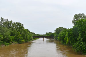
Smoky Hill River near Enterprise, Kansas, in Dickinson County.
In 1948, the U.S. Army Corps of Engineers completed construction of a dam on the Smoky Hill River to control floods in southeastern Ellsworth County, creating Kanopolis Lake. In 1951, the United States Bureau of Reclamation completed another dam on the river for flood control and irrigation. This dam created Cedar Bluff Reservoir in southeastern Trego County.
©Kathy Alexander/Legends of Kansas, updated June 2026.
Also See:
See Sources.