
Atchison, Topeka, and Santa Fe engine, coal car, and caboose steaming over double arch style railroad bridge between Wellsville and Le Loup, 1910.
| Town | Post Office Dates | Additional Information |
| Berea | 1863-1870 | Burea began when Reverend J. N. Smith brought a small body of United Presbyterians into the southern part of the county in 1857. William Aikin taught the first school in the winter of 1857-58. The group built a church in 1858 of native lumber. The same year, the town was laid out, and soon the town company built a store. A schoolhouse was built in 1861, and a post office was established in 1863. The Associate Presbyterians built a church in 1867. In 1870, the United Presbyterians built a larger, better-framed building for $1,400. In 1870, the office was removed to Richmond, a new railroad town three miles west, and the town died. |
| Bowling Green | 1855-1857 | |
| Centropolis | 1858-1859 1863 1865-1930 |
Centropolis is an unincorporated community and an extinct town because it no longer has a post office. Perry Fuller first settled in the area in 1855 and established a store in order to trade with the nearby Ottawa Indians. As of the 2020 census, the population of the community and nearby areas was 100. It is located about 11 miles northwest of Ottawa. It still has several buildings, including two active churches. |
| Coburn | 1900-1902 | In the northwestern part of the county, it was ten miles west of Norwood, the nearest railroad station. |
| Dennison | 1865-1868 | |
| Emerald | None | First settled in 1857. |
| Forest Home | 1867-1877 | The post office moved to Homewood. |
| Garlington | 1886-1898 | The post office moved to Pleasanthill. |
| Greenwood-Sac & Fox Agency | 1855-1872 |
 Sac & Fox Agency. Greenwood Township, in Franklin County, was organized in 1865. It was initially part of Ohio Township and was first called the Sac & Fox Agency when a post office was established on March 3, 1855. The name changed from Sac & Fox Agency to Greenwood on February 27, 1861. |
| Hackett | 1900-1903 | In the northern part of the county, it was located in the valley of Eight Mile Creek, about six miles northwest of Ottawa. |
| Hickory Creek | 1859-1860 | |
| Homewood | 1877-1955 |
 Homewood School. The post office moved from Forest Home. Homewood, in Williamsburg Township, was located on the Atchison, Topeka & Santa Fe Railroad, 11 miles southwest of Ottawa. In 1910, it had general stores, a public school, a money order post office with one rural route, telegraph and express facilities, and a population of 100. Located in a rich agricultural district, it serves as the supply and shipping point for the surrounding area. Today, the area still features several homes, a couple of old business buildings, the old Homewood School, and an active church. |
| Imes-Larimore | 1877-1917 | Larimore was a small town on the Missouri, Kansas & Texas Railroad about six miles southeast of Ottawa. The name changed from Larimore to Imes on May 23, 1887. Named for Harmon Imes, the postmaster. In 1910, it was located on the Missouri Pacific Railroad, had a money order office, was a shipping point for the rich agricultural district, and had a population of 40. |
| Le Loup-Ferguson | 1870-1954 | In the northeastern part of the county, it started as a station on the Leavenworth, Lawrence & Fort Gibson Railroad in 1870. The name was changed from Ferguson to Le Loup on May 8, 1879. There are still a few homes in the area. |
| McCandless | 1900-1901 | |
| Minneola-Saint Bernard | 1855-1865 | The name changed from Saint Bernard to Minneola on November 26, 1858. It served as the seat of Franklin County for a brief period. The post office moved to Centropolis when it closed. St. Bernard was established just a couple of miles east of Centropolis and was made the Franklin County seat. However, it did not grow, and the post office was closed and was renamed Minneola. |
| Norwood | 1868-1872 1874-1914 |
Located in northern Franklin County, it was served by the Kansas City, Lawrence & Southern Kansas Railroad. It was named after Henry Ward Beecher’s novel. When the post office was established, D.W. Moore was appointed the first Postmaster. Balch & Hedrich opened a store in 1878. In 1910, Norwood was on the Atchison, Topeka & Santa Fe Railroad. It had several stores, a money order post office, telegraph and express facilities, and was the shipping and supply point for a rich agricultural district. At that time, its population was 37. |
| Ohio City | 1857-1870 | Located on the Humboldt Trail, Ohio City was laid out in April 1857. It briefly served as the county seat of Franklin County. The post office relocated to Princeton, approximately two miles away, after it closed. A two-story hotel was the first building erected, and the first store was built by J.W. Iliff, with funds raised through popular subscription. W.E. Kibbie built the first frame house, founded the first school, and served as the first Postmaster. The first steam saw mill was erected by Morton & Painter on Middle Creek, a little above Ohio City. At the height of its prosperity, Ohio City contained about 100 inhabitants. But as Ottawa grew, many people moved away to the new town and county seat, others to other places, and still others into the countryside. The post office moved to Princeton when it closed. |
| Ottawa Creek | 1856-1864 | The post office moved to Ottawa. |
| Pansy | 1898-1902 | |
| Peoria | 1857-1934 |
 Briles School, Kansas. Named for Baptiste Peoria, leader of the Peoria Indians, Peoria was one of the county’s earliest towns. It was established in 1857 by Alfred Johnson and Jacob Sumstine, both free-staters. Peoria was six miles east of Ottawa. The old Briles one-room school remains. |
| Pleasanthill | 1898-1902 | The post office moved from Garlington. |
| Ransomville | 1881-1915 | It was a coal mining camp located in the southwestern part of the county. |
| Richter | 1890-1907 | Located halfway between Ottawa and Pomona, the community of Richter first served as a stage stop before the Atchison, Topeka & Santa Fe Railroad came through in 1883. It was later served by the Missouri Pacific Railroad in 1885. In its earliest years, the town included a mercantile store, a grain elevator, a railroad depot, and a Methodist church. |
| Sac Branch | 1861-1863 | |
| Shermansville-Sherman’s- Dutch Henry’s Crossing | 1855-1863 | The post office moved to Lane. |
| Silkville | NA | Silkville, Kansas, in Franklin County, was a collection of private buildings owned by the Frenchman Ernest de Boissiere, whose 3,600-acre farm was managed by Charles Sears. |
| Woodlief | 1898-1901 |
©Kathy Alexander/Legends of Kansas, updated July 2026.
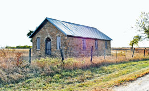
Old School in Silville, Kandas by Kathy Alexander.
Also See:
Sources:
Blackmar, Frank W.; Kansas: A Cyclopedia of State History, Vol I; Standard Publishing Company, Chicago, IL 1912.
Cutler, William G.; History of Kansas; A. T. Andreas, Chicago, IL, 1883.
Kansas Post Office History