
Franklin County, Kansas Landscape by Kathy Alexander.
Towns & Places:
Centropolis – Extinct
Lane
Ottawa – County Seat
Pomona
Princeton
Rantoul
Richmond
Wellsville
Williamsburg
One-Room, Country, & Historic Schools of Franklin County
Ottawa University
Capps Lake
Gilkey Lake
Kansas River
Marais des Cygnes River
Natural Springs Lake
Pottawatomie Creek
Richmond Lake
More:
Early Indian Residents of Franklin County
Franklin County Photo Gallery
Pottawatomie Massacre
Pottawatomie Rifles
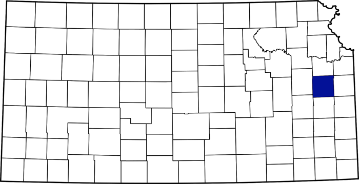
Franklin County, Kansas Location

Franklin County, Kansas by L.H. Everts & Co., 1887.
Franklin County, Kansas, is located in the state’s eastern portion. The county seat and the most populous city is Ottawa. As of the 2020 census, the county’s population was 25,996, its peak.

Osage camp, by O. Drum, 1906.
The area was included in a 1808 treaty ceding land to the Osage Nation, but was returned to the federal government in 1825. Afterward, several treaties were made with other Indian nations, which set off parts of what would later become Franklin County for their use.
In 1837, the Potawatomi Indians were removed to a tract of land in the southeast part of the county, and in 1847-48, they were removed to Pottawatomie County.
The Kansas Territory was organized in 1854, and Franklin County was one of the 33 original counties created by the first Territorial Legislature of 1855. The county was named after Benjamin Franklin.
Franklin County is located in the second tier of counties west of Missouri and south of the Kansas River. It is bounded on the north by Douglas County, east by Miami, south by Anderson, and west by Coffey and Osage Counties.

Marais des Cygnes River.
The bottomlands accounted for approximately 16% of the surface area. In the valley of the Marais des Cygnes River, they averaged about two miles in width, in that of the Pottawatomie Creek about one mile, and in those of Middle and Ottawa Creeks about one-half mile. The uplands comprised about 84% of the surface, generally level or gently undulating prairie. The most uneven portion was in Pottawatomie Township, which occupied the county’s southeastern corner. Here, the highest hills rise about 200 feet above Pottawatomie Creek and are sometimes steep and challenging to climb. There are some hilly sections about four miles southwest of Ottawa, about the same distance southwest, and about two miles west of Richmond.
The soil is sandy loam and generally exceedingly fertile. It ranges from 1 to 2 feet deep on the uplands, whereas in the stream valleys it averages three feet deep. In the latter, it is in places immediately underlain by gumbo soil on clay, which provides excellent drainage.
Good limestone was found at an average depth of 12-20 feet and was distributed throughout the county. In some areas, sandstone was too soft to be of much value for construction.
Coal underlies about 20% of the county. It was found to be most abundant in the western and southwestern parts, and approximately six miles northwest of Ottawa. It was observed in the ravines and was recovered at a depth of 20 feet. The vein averaged two feet in thickness, and the quality is good. In 1881, about 5,000 tons were mined, mostly in Williamsburg Township.
About 8% of the county was covered with timber, mostly confined to the streams. The native tree varieties were cottonwood, elm, hackberry, hickory, honey locust, mulberry, oak, soft maple, walnut, and willow. The principal stream is the Marais des Cygnes (Marsh of Swans), which enters the county from the west and flows eastward through it into Miami County. Pottawatomie Creek is second in size, entering near the southeast corner and flowing northeastward into Miami County, uniting at Osawatomie with the Marais des Cygnes. Middle Creek rises in the west part of the county and flows northeastward into the Marais des Cygnes near Peoria. Ottawa Creek rises in Douglas County and flows south into the Marais des Cygnes near Peoria. Appanoose Creek rises in Osage County and flows southeast into the Marais des Cygnes, four miles west of Ottawa.
Eight Mile Creek rises in Douglas County and flows south into the Marais des Cygnes one mile west of Ottawa. Hickory Creek rises in the eastern part of the county and flows south into the Marais des Cygnes, three miles west of the eastern county line. Turkey Creek rises in Miami County and flows southwest into the Marais des Cygnes River, a little east of the mouth of Hickory Creek. Walnut Creek rises near the county’s northeast corner and flows southwest into Ottawa Creek, four miles northeast of Ottawa. Wolf Creek rises in the north part of the county and flows south into Walnut Creek near its mouth. Coal Creek rises near Williamsburg and flows north into the Marais des Cygnes, eight miles west of Ottawa. Rock Creek rises in the county’s southwestern part and flows northeast into the Marais des Cygnes, two miles east of Ottawa. Sac Creek rises near Williamsburg and flows southeast into the Pottawatomie River in Anderson County. Sac Branch rises in the southeastern part of the county and flows into the Pottawatomie, near Lane. The county was well supplied with springs, and good well water was obtained at depths of 20 to 40 feet.

Ottawa Indians.
Because most of the land in Franklin County was occupied by several Indian tribes, the titles to those reservations were not extinguished until 1862, 1864, and 1867; the county’s settlement was not as early as that of adjoining counties. Along the northern edge, however, on what was known as the “Shawnee Purchase,” a strip of land about three miles wide, the Shawnee title to which was extinguished by the treaty of May 10, 1854, several settlements were established in that year.
The first settler in the county was Reuben Hackett, who settled near the west line of what is now Hayes Township on June 7, 1854, on the west branch of the Ottawa Creek and near the north line of the county. Amos Hanna moved in about the same time. Several others came into this part of the county during the same year, including Reverend William Moore and four or five sons, who settled about a mile east of the old townsite of Norwood.
Franklin County was organized in 1855, and the Governor appointed a partial set of officers.
In 1857, an election was held, and a complete set of officers was chosen. The first officers of the county were as follows: Commissioners — J.A. Marcell, William Thornbrough, and John F. Javens; J.A. Marcell, also being Probate Judge; Clerk, Robert. Cowdin, Treasurer, T.J. Mewhinney; Sheriff, C.L. Robbins; Prosecuting Attorney, P.P. Elder; Register of Deeds, William Austin; Coroner, John Bingham.
That year, quite a large number had settled on West Branch: Jacob, John, Lemen, William and Elville Copple; Rudolph Miller and seven sons; William Hackett, C.P. Sherman, Louis Allison, Daniel Heverlain, a Mr. Craven, William Sutton, Daniel Storrs, Jesse and John Moore, a Mr. Wright, F.M. Hodges, Thomas Mewhinney, Jacob Brunck and David Hodges; and on the east branch of Ottawa Creek, Esquire Merchant, Calvin and John Leonard and John Heck.
The first settlers in Appanoose Township were Missourians who came in 1856; C. Shrimp, Washington Baker, James Cleveland, and Mr. Foster were among them. In 1857, Daniel Dean, T.H. Tutcher, Henry Hour, and James Belly settled on the west branch of Appanoose Creek, and on the middle branch, Moses Beamed, J.A.W. Wadsworth, and the widow Critchfield. In 1858, the following individuals were added to the above list: Thomas Tutcher, Sr., Alfred Tutcher, M. St. John, W. Beard, J.W. Davis, John Logan, and H. Gilbert.
Sometime after this township was settled, J.H. Whetstone conceived the idea of establishing a colony in its western part. To this end, he purchased a tract of land north of the Marais des Cygnes River, primarily in a single body, totaling about 15,000 acres. This purchase was made in 1869. In 1870, S.T. Kelsey became associated with Mr. Whetstone. They then parcelled out their purchase into small farms, intending to sell to parties intending to become actual settlers and thus form a colony, each of whom should own a farm or a village lot. To accommodate those who preferred village life, the town of Pomona was platted in 1870. Appanoose Township was organized on May 17, 1871. It was formed from portions of Centropolis Township and the Sac and Fox Reservation.
The land now included in Harrison Township, in the center of the county, was opened to settlement in 1865, following the removal of the Ottawa Indians. The Indian lands were generally sold to the highest bidder, with very little purchased by speculators.
The first settler was Enoch Pyle in the fall of 1865. Later in the same year, or in the spring of 1866, the following parties came into the township: John Howell, Mr. Hood, James Hill, J.R. Dailey, Mr. Spencer, and Michael Hornbeck. In 1866, these were followed by W.L. John and Thomas Harrison, Henry and Jacob Fouts, E. Walker, Mr. Smith, and Charles Howell; in 1867, by N. Latimer, G.W. Castzdafner, Joseph Guy, Mr. Greeves, Mr. Skeeles, Mr. Curtis, Mr. Payne, and Dr. Van Schoick. In 1868, a large influx of immigrants led to the locality’s dense settlement. Harrison Township was organized, taken in part from the Ottawa Reservation and in part from Ohio Township. J.R. Daley built the first stone house on the Ottawa Reserve outside Ottawa. A schoolhouse was built in the Fouts neighborhood. It has since been replaced by a stone one. Enoch Pyle and the Harrisons were the first to break and fence in the township. The first settlement in Centropolis Township was made on Eight Mile Creek in 1854, near the old townsite of Centropolis. This was on land opened to settlement by the May 10, 1854, treaty with the Shawnee Indians.
This pioneer party of settlers consisted of about 15 members, whose names, as far as can be ascertained, are as follows: Joab M. Bernard, Timothy Keizer, Jacob Clark, I.C. Hughes, Thomas Doty, John F. Javens, Franklin Barnes, Johnson Farris, Perry Fuller, Leander McClellan, John E. McClellan, and Mansfield Carter. They arrived and camped on Eight Mile Creek on the evening of June 26. In the morning, it was proposed that a vote be held on whether Kansas should be a free or slave state; all voted for a free state except for two: Joab M. Bernard and Timothy Keizer. Having settled this matter, each member settled their claim. J.M. Bernard’s was immediately east of and adjoining the present town site of Centropolis. This was on June 27. John F. Javens built the first cabin on Eight Mile Creek near Centropolis, and Perry Fuller built it on the town site. The first election these settlers attended was in the fall of 1854, at what is now Prairie City in Douglas County, but when they found the polls in the hands of Missourians, they returned home without voting.
Sometime early in 1855, J.M. Bernard opened a store on his quarter section, was appointed postmaster on March 3, and the post office was named after him, Saint Bernard. The people then obtained their mail at St. Bernard rather than in Kansas City until 1858, when a post office was established at Minneola. J.M. Bernard, a pro-slavery man in the Missouri Legislature of Kansas Territory in 1855, located the county seat at St. Bernard. The town, however, never either grew or prospered and was at last extinguished by a raid on Mr. Bernard by Free-State men to whom he had become very obnoxious. When Mr. Bernard was gone, nothing was left of the town, and no attempt was made to revive it.

Minneola, Kansas, General Location Today.
In 1855, Perry Fuller built a frame store on the site of present-day Centropolis, primarily to trade with Native Americans. A town company was formed the following year, and a thriving settlement grew here.
In the county’s northeast corner, the first settlers in Franklin Township were William Thornbrough and Lewis Reed, who settled on Walnut Creek in 1856. In early 1857, Dr. I. Pile, Nathan Mowry, Mr. Phillips, George E. Sweetzer, and Mr. Armstrong also settled there. During the same year, many squatters asserted that they were agents of speculators. In time, however, the entire township was occupied by bona fide settlers and became thoroughly settled.
The settlement of the southern part of Franklin County was greatly retarded for some years by the purchase of the land by speculators, who persistently held it at prices above the means of the majority desiring land for settlement.
The first settler in Ohio Township is believed to have been Thomas Ivy, who was located on Upper Middle Creek in 1855. During the same year, the following also selected claims upon the stream: Judge Merritt, James Carter, Mr. Montgomery, Mr. Robinson, Mr. Epperson, Jacob Bolman, William Agnew, D.R. Ricker, Hiram Howard, and Calvin Randall.
In 1857, the lands came onto the market, and significant immigration ensued, mainly from Ohio. Among these were John Dietrich, William Fugate, Joseph Smith, John E. Baer, Thomas, Ezekial, and Emmanuel Jenkins, P.P. Elder, W.E. Kibbie, John Hendricks, J.W. Iliff, D.C. Wetherwax, Abram Shanks, Benjamin Briggs, B.C. Sanford, J.H. Cook, A.R. Morton, Reuben Painter, David Baer, John Baer, William Servatus, Robert Cowder, William A. Morton, James Carl, and Mrs. Johnson, all Free-state but the first two. In 1858, William Nightingale and James McFaddin, who were pro-slavery, moved in from Missouri.
In the spring of 1861, there were 2,500 inhabitants in the county, scattered along the northern and eastern borders, with a somewhat compact settlement a little south of the center at Ohio City. The remainder of the county was ceded to the Indians, who were granted reservations. When the Civil War erupted, there was little village life and no rallying points, and consequently, those whose patriotism impelled them hastened to Lawrence and other nearby stations to enlist. Company D of the Twelfth Infantry was the only company wholly recruited in the county. It was mustered September 25, 1862, and was officered by George W. Ashby of Ohio City, Captain Henry Shively, near Stanton, First Lieutenant, and Alfred Johnson of Peoria, Second Lieutenant. However, the county furnished individuals or squads to almost every regiment organized in the state until hardly any able-bodied man was not under arms. There were 20 enlisted men in the First Kansas Infantry, and about the same number were in the Second. These regiments participated in the bloody battle of Wilson’s Creek, Missouri, on August 10, 1861, and the little town of Minneola alone lost five men in that battle. The county also furnished 16 men to the First Battery, many to the Second Cavalry, and probably 50 to the Sixteenth Infantry.
On August 1, 1864, Ottawa, Kansas, became the county seat of Franklin County.

Kansas Militia.
In October 1864, Governor Thomas Carney called out the State Militia to repel the invasion threatened by Confederate General Sterling Price. The Tenth Kansas State Militia, among others, promptly responded to the call. This regiment had been recruited from Franklin and Anderson Counties. The regimental officers were William Pennock, Colonel of Centropolis; Miles Morris, Lieutenant-Colonel, Garnett; A. Niley, Major, Garnett; J. K. Goodkin, Adjutant, Minneola; I. C. Huges, Quarter Master, Minneola; Mr. F. Holiday, Surgeon, Lane. Company A was from Centropolis and Minneola; Companies C and D were from Peoria; Companies F and L were from Ottawa; Company G was from Ohio City; and Company H was from Berea. There were no battles or skirmishes within the limits of the county.
In the early 1880s, there were 90 school districts in the county and 89 schoolhouses. According to the 1881 census, there were 6,025 children aged 5 to 21, of whom 4,543 were enrolled, and 2,934 were in average daily attendance. The number of teachers employed, excluding Ottawa Public Schools, was 95, with the average wage for male teachers $32.60 and for female teachers $21.45. An advance in wages was made the following year, and a higher standard of qualification was required for teachers. The value of school sites, buildings, and property was $98,052. The highest-scoring subjects in the eighth year were history, geography, bookkeeping, grammar, and arithmetic. The first class to graduate in this course in Franklin County was on July 7, 1882, in district No. 41.
Franklin County was well supplied with railroads. The Kansas City, Lawrence & Southern Kansas Railroad ran from north to south through the county. A line operated by the same company, running from Ottawa, through Olathe, to Kansas City, 55 miles distant. The Ottawa & Burlington Railroad ran southwesterly from Ottawa to Burlington in Coffey County. The Leroy Branch of the Missouri Pacific Railroad ran from Osawatomie, Miami County, to Ottawa, and the Kansas City & Emporia Railroad was running westward to Emporia. The Missouri Pacific Railroad ran across the southeast corner of the county. All these roads, except the Missouri Pacific, were centered in Ottawa.
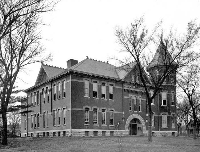
Ottawa, Kansas High School, about 1910.
By 1910, Franklin County’s schools were among the best in the state. There were 94 organized school districts and a school population of 6,624. In addition to the district and high schools, Ottawa University in Ottawa, established in 1860 and supported by an endowment, is also located in Franklin County.
While Franklin County was predominantly agricultural, a few other industries were also operating successfully at the time. These included flour mills, furniture factories, brick-and-tile factories, machine shops, and soap factories. In earlier days, an effort was made to establish a silk industry.
Winter wheat, Irish potatoes, and flax were essential crops, but corn was the leading cereal. Significant effort was devoted to livestock production and fruit tree cultivation, with 150,000 bearing fruit trees in 1907.
In 1910, the assessed valuation of Franklin County property was $32,342,026. The total value of field crops was $1,630,506, with the five leading crops being corn ($822,603), hay ($387,269), oats ($171,931), wheat ($74,631), and Kafir corn ($57,264). The value of animals slaughtered or sold for slaughter was $940,605, and the value of dairy products was $350,834.
The county covers an area of 576 square miles (368,640 acres).
©Kathy Alexander/Legends of Kansas, updated May 2026.
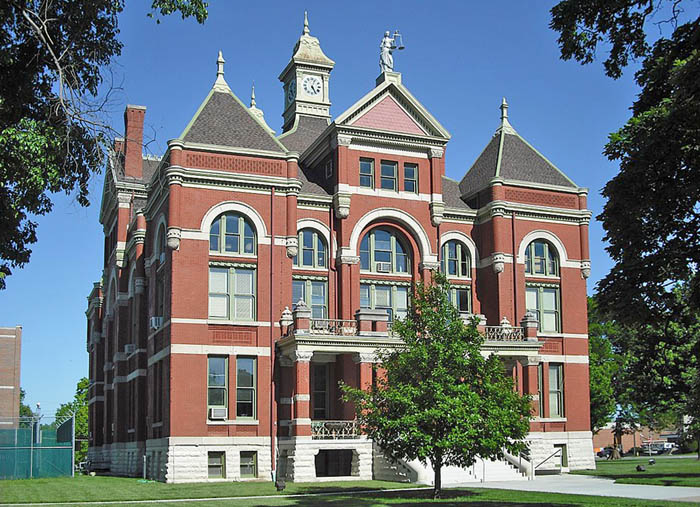
Franklin County courthouse in Ottawa, Kansas, courtesy of Wikipedia.
Also See:
Sources:
Blackmar, Frank W.; Kansas: A Cyclopedia of State History, Vol I; Standard Publishing Company, Chicago, IL 1912.
Cutler, William G.; History of Kansas; A. T. Andreas, Chicago, IL, 1883.
Wikipedia