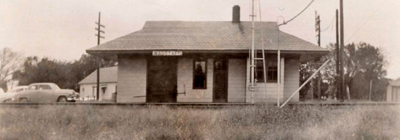
Missouri Pacific Railroad Depot in Wagstaff, Kansas by H. Killam, 1958.
| Town | Post Office Dates | Additional Information |
| Amo | 1877-1879 | |
| Antioch | 1893-1901 |
Still features an old school and active Baptist Church. It is situated on 223rd St and Waverly Road. |
| Beagle | 1888-1955 |
A village in the southwestern part of the county, it was on the Missouri Pacific Railroad about 15 miles southwest of Paola. In 1910, it had a money order post office, telegraph, and express offices, a good local retail trade, and a population of 180. A few homes remain in the area today, plus an active Methodist Church. |
| Block | 1884-1904 | A hamlet located about eight miles southeast of Paola. Paola was the most convenient railroad station. |
| Chiles | 1891-1943 |
A post-village in the northeastern part of the county was a station on the Missouri Pacific Railroad 11 miles northeast of Paola. In 1910, it had a money-order post office, a telegraph station, and a population of 100. There are still several homes in the area and the active Elm Grove Baptist Church. It is located at W 247th Street and Lackman Road. |
| Duncan | 1900 | The post office was open for about ten months. |
| Indianapolis | 1858 1860-1863 |
Indianapolis was situated two and one-half miles west of Osawatomie and, in 1858, had a store, a post office, about 12 residences, and a population of 50-60. |
| Jingo | 1885-1902 | A hamlet in the southeastern part of the county, it was about ten miles northeast of La Cygne. In 1910 there was a population of 40. |
| Lento | None | A Missouri Pacific Railroad station. |
| Lodi | 1867-1888 | The post office moved to Saint Louis, which was later called Louisburgh. |
| Lyons/Saint Marysville | 1858-1867 | In 1857, James Beets and H. L. Lyon surveyed and platted the townsite and called it Saint Marysville. The town soon had two general stores, a hotel, a post office, blacksmith and wagon shops, and a school. The name changed from Saint Marysville to Lyons on February 19, 1859. As the country was settled and railroads built, Lyons was not so fortunate as to be in the course of any railroad. New business centers were established as railroad stations, and the settlement became a deserted village. The post office moved to Tontzville when it closed. |
| Max | 1883-1889 | |
| Miami Village | 1856-1870 | |
| Midway | 1857-1860 | |
| Mound Creek/Trenton | 1876-1894 | Mound Creek was situated in Mound Township. The first settlement was made on November 5, 1854, by Thomas and Henderson Rice, and J F. and T. J. Chandler moved in on July 3, 1856. A store was opened on April 5, 1856, by Thomas Rice. The first school taught was by Loyal Bishop, commencing in November 1858, in a log schoolhouse on the farm of Thomas Rice, at whose house Reverend Amos Finch preached the first sermon in 1856. The Society of Friends built a church in the west part of the township in 1858, a commodious frame building, 30×45 feet. There were about 50 members of the society. The Christian Church was organized in September 1860 with six members. The Baptists and Methodists also had organizations, but none of the last three denominations had a church building.
The settlement was first called Trenton, and when a post office opened on December 10, 1860, with Henderson Rice as the first Postmaster. At some point, the post office closed and reopened on August 15, 1861. It closed again on September 9, 1862. More than a decade later, another Mound Creek post office was established on March 14, 1876. This name was called such for a peculiar mound in the western part of the settlement. The post office closed for the final time on April 14, 1894. |
| Mount Nebo | 1868-1871 | |
| New Lancaster | 1859-1906 | A hamlet located near Middle Creek in Miami Township, about 12 miles southeast of Paola. Though long extinct, this place has a few residents and two buildings listed on the National Register of Historic Places — Grange Hall and the New Lancaster General Store. |
| Novelty | 1881 | The post office was open for less than a month. |
| Obrien Station | 1884-1885 | |
| Osage | 1864-1869 | The post office moved to Fontana. |
| Pendleton | 1883-1905 | A hamlet situated on the St. Louis & San Francisco Railroad five miles southeast of Paola. |
| Peoria Village | 1855-1856 | Established in Lykins County. The post office moved to Paola when it closed. |
| Pressonville | 1898-1901 | A hamlet in the northwestern part of the county was about 15 miles northwest of Paola. It had a population of 20 in 1910. |
| Rockville/Rockwell | 1862-1902 | A hamlet in the southeastern part of the county, it was situated on Sugar Creek. Confederates attacked it in the Civil War. |
| Ross | 1869 | The post office was open for less than four months. |
| Somerset | 1871-1933 | A village in Middle Creek Township on the Missouri, Kansas & Texas Railway, eight miles northeast of Paola. It was surveyed and platted on May 17, 1871, by a town company composed of New Jersey people, of which Reverend John S. Beekman was president, and Henry H. Striker, secretary. The company owned a tract of 1,100 acres; 215 were platted.
Captain Will Glicks opened the first store in the fall of 1871, and the town company started a grist and sawmill about the same time. A post office was established on October 25, 1871, with Peter A. Brokan as Postmaster. The town flourished for some years, but owing to the superior advantages and attractions of the neighboring cities of Paola and Louisburg, it failed to meet the expectations of its founders. In the early 1880s, it had about 30 residents. In 1910, it had several general stores, a blacksmith shop, a church, and a schoolhouse surrounded by a rich agricultural community. At that time, its population was 60. Its post office closed on December 30, 1933. Today, this old community still has a few scattered homes, one of which was an old schoolhouse. |
| Stanton | 1857-1903 | One of the oldest towns in Miami County, Kansas, Stanton, was located on the Marais des Cygnes River, about seven miles northwest of Osawatomie, near the county’s western boundary. |
| Sugar | 1885-1893 | |
| Tontzville | 1867-1874 | The post office moved from Lyons. |
| Upton | 1872-1876 | |
| Wade/Wades Branch | 1874-1900 | A hamlet in the northwestern part of the county was about 11 miles from Paola. Wellsville was the nearest railroad station. The post office moved from Wades Branch to Wade on December 6, 1880. |
| Wagstaff | 1888-1933 | It was a village in northeastern Miami County on the Missouri Pacific Railroad, eight miles northeast of Paola. In 1910, it had a money order post office, telegraph and express offices, and a population of 35. |
| Wea | 1867 1873-1903 |
A hamlet in the extreme northeastern part of the county, about five miles east of Bucyrus. |
| Whittaker | 1890-1900 |
©Kathy Alexander/Legends of Kansas, updated February 2025.
Also See:
Sources:
Blackmar, Frank W.; Kansas: A Cyclopedia of State History, Vol I; Standard Publishing Company, Chicago, IL 1912.
Cutler, William G; History of Kansas; A. T. Andreas, Chicago, IL, 1883.
Kansas Post Office History


