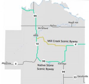
Wabaunsee County Scenic Byways
The Native Stone Scenic Byway, known for its native limestone in northeast Kansas, runs 75 miles through the gorgeous Flint Hills.
Natural limestone, Kansas’ bedrock, is found throughout the byway in hillside formations, stone buildings, and rough-hewn fences framing grasslands and ranching areas. These features highlight the natural wonders and the craftwork of pioneer stonemasons from Sweden and Germany who helped build these communities.
The limestone from which the byway gets its name was formed from the sediments of shallow seas that existed over 240 million years ago.
The locally quarried beautiful blond stonework is the cornerstone of the Native Stone Scenic Byway. The limestone was more than an aesthetic choice; it is a part of the area’s history and heritage. These many stone fences and architecture were pioneered by settlers who had limited access to trees. Adding more inspiration to the pioneers was a 1867 law abolishing the open range, providing for payment of 40¢ per rod (16½ feet) to landowners to build and maintain a 4.5-foot stone fence. As stone was plentiful in the area, pioneers built miles of fences.
Along the winding path, visitors experience historic agriculture, cattle ranches, vast prairie vistas, seasonal foliage, and wildflowers that began during the days of Bleeding Kansas and the Underground Railroad. Much of the roadway, created by early pioneers, follows the contours of the land, passing through Dover, Keene, Eskridge, Alma, Wabaunsee, and Zeandale.

Rock fence on K-4 Highway, courtesy Google Maps.
Designated as a scenic byway in 2006, the route begins northeast of Dover in Shawnee County and winds along K-4, K-99, K-18, and K-177 through Shawnee, Wabaunsee, Geary, and Riley Counties.
The route begins northeast of Dover, which was named for the white cliffs of Dover, England, at the intersection of K-4 and Glick Road.

Echo Cliff Park in Wabaunsee County, Kansas, courtesy of the Kansas Geological Survey.
From here, head west on K-4 towards Eskridge, Kansas. About one and a half miles west of Dover, a left turn onto Echo Cliff Road will take visitors to Echo Cliff Park one mile to the South. This park is comprised of sandstone bluffs that wind along Mission Creek in eastern Wabaunsee County. Towering 75 feet above Mission Creek, Echo Cliff was formed from a series of events driven by the movement of seas and streams. Archaeological evidence shows that Woodland Indians lived or camped here over 800 to 1,000 years ago. In addition to beautiful views, fishing, hiking trails, and picnic tables are available.
Return to K-4 and continue to travel west. About 4.3 miles away is the tiny unincorporated community of Keene, which was once an Underground Railroad site. Then continue for about ten miles southwest on K-4 to Eskridge, the “Gateway to the Flint Hills”. Just 4.5 miles West of Eskridge is Lake Wabaunsee, which once served as a training ground for American soldiers and a POW camp for captured German soldiers during World War II. Attractions at Lake Wabaunsee include the Wabaunsee Pines Golf Course, Lake Bum’s Bait Shop, a swimming area, and camping facilities.
Continue west for 5.5 miles to the intersection of K-4, then make a right on K-99 toward Alma, Kansas. Continue for nine miles to reach the Wabaunsee County seat at Alma. Known as the “City of Native Stone,” the downtown historic district displays 21 buildings of architectural significance between 1880 and 1936. The city is also home to the Wabaunsee County Historical Museum, with photo and artifact displays that provide information on the area’s historic sites. Alma is also part of the Scenic Mill Creek Drive.
Continue north on K-99 for ten miles. At the Intersection of K-99, a right turn onto Mt. Mitchell Rd for a half mile to Mount Mitchell Heritage Prairie Park.

Mount Mitchell in Wabaunsee County, Kansas.
This historic site celebrates the accomplishments of Connecticut abolitionists who helped defeat slavery in Kansas. Once part of the Captain William Mitchell farm, here was a station on the Underground Railroad. The 170-acre Park is a Star Attraction of the Freedom’s Frontier National Heritage Area. The site’s hilltop prairie overlooking the Kansas River Valley has been sacred to Native Americans and was visited by explorers such as John C. Fremont, who scouted the Oregon Trail, trappers and traders headed to the Rocky Mountains, and soldiers along the Topeka-Fort Riley Road. The park also offers the endangered tallgrass prairie of the beautiful Flint Hills, an official Monarch Butterfly Waystation, wild flowers, quartzite boulders carried in and dumped by glacial ice about 600,000 years ago, the log cabin farmstead of Captain Mitchell, and a panoramic view of the Kansas River Valley.

Beecher Bible and Rifle Church in Wabaunsee, Kansas by Kathy Alexander.
Continue the journey by heading west on Mt Mitchell Rd for a half mile, then continue onto KS-18 for about two and a half miles to Wabaunsee, Kansas.
Wabaunsee was one of the earliest settlements in the area. The heart and soul of the community is the Beecher Bible and Rifle Church, which still has an active congregation. This stone structure has witnessed a lot of history while the town prospered, then faded when school consolidation and lack of businesses took their toll. In its early years, Wabuansee stood up for its beliefs to help make Kansas a Free-State.
Continue west on KS-18 for 10.8 miles to the unincorporated community of Zeandale, Kansas.
Although it is a ghost town today, it began in 1854 with the help of the New England Emigrant Aid Company. An 1896 church, now called the Zeandale Community Church, still stands and provides services.
A side trip presents itself here, just about three miles southwest at the Pillsbury Crossing Wildlife Area.
Pillsbury Crossing is a beautiful natural limestone slab that pioneers used to cross Deep Creek in Riley County, Kansas. The ledge terminates in a picturesque waterfall about 50 feet wide that drops about five feet. Below Pillsbury Crossing, Deep Creek flows into the Kansas River. It is at 2464-2484 Pillsbury Crossing Ln, Manhattan, Kansas.
Return to K-18 and continue west for about seven miles to Manhattan. Once you reach K-177 just outside of Manhattan, make a left turn onto K-177 and continue south for about three miles to the Konza Prairie Kansas Valley lookout point. Home to some of the most beautiful views in Kansas, the Konza Prairie features 8,600 acres of quiet, rolling hills marked with flint and limestone, dominating the landscape. Visitors can spend the day hiking miles of native plants and beautiful scenery on nature trails or picnicking with Mother Nature. Kansas State University Division of Biology manages the land that the Nature Conservancy owns. Open 365 days a year to the public, from dawn to dusk. The trails are designed for walking only — no bikes or motorized vehicles.
This location is part of the Freedom’s Frontier National Heritage Area, where extraordinary events forever changed America. In the 19th century, the nation turned its eyes to the Missouri-Kansas border, where people with diverse definitions of freedom collided, inciting and fueling a Civil War.
Continue South for about five miles until the route concludes at I-70 exit 313.
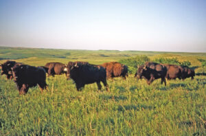
Bison on the Konza Prairie, courtesy of the Kansas Geological Survey.
The Native Stone Scenic Byway highlights both the natural wonder of rock formations and the excellent craftwork of masons who built the small towns and communities with native stone.
©Kathy Alexander/Legends of Kansas, June 2025.
Also See:
Sources: