
Cowboys at the 101 Ranch south of Hunnewell in about 1880.
| Town | Post Office Dates | Additional Information |
| Abrellville | 1873 | The post office was only open for four months. |
| Adamsville | 1925-1931 | Adamsville, Kansas, is a ghost town in Sumner County. The unincorporated town gained a post office on July 15, 1925, and closed less than six years later, on March 31, 1931. It was located along an abandoned railroad from Oxford to Geuda Springs. It is about four miles north of Geuda Springs, 0.5 miles west of the intersection of S Oxford Rd and E 80th Street. There are just a few abandoned buildings and a silo today.
 Adamsville, Kansas, courtesy of Google Maps. |
| Alton | 1872-1881 | Located in Falls township between Bluff Creek and the Chikaskia River in the southern central part of Sumner County, Alton was first settled in 1871. In 1880, it had Methodist and Baptist societies, a district school, a blacksmith, a sawmill, two physicians, a carpenter, and a harnessmaker. Mail stages ran to Caldwell, South Haven, and Wellington daily. At that time, its population was 75. It was three miles east and a mile and a half south of Caldwell at about 1800 S. Mayfield Road. |
| Anson | 1887-1958 | Anson was situated on the Missouri Pacific Railroad in Sumner Township, about ten miles northwest of Wellington. In 1910, it was described as a thriving little town with a population of 125. At that time, it had a bank, mercantile and shipping interests, a money order office, express and telegraph accommodations, and good schools. This tiny extinct town still had named roads and several houses. It is located 1.5 miles south of the intersection of N Anson Rd and W 90th St N, next to an abandoned railroad.
 Anson, Kansas, courtesy of Google Maps. |
| Argyle | 1874-1881 | Located in the northern central part of Sumner County, it had a Methodist Episcopal church, a district school, a semi-weekly mail service, and a population of 20 in 1880. Wellington was the usual shipping point and the location of the nearest bank. It was ten miles north of Wellington and eight miles from Belle Plaine. |
| Ashton | 1887-1971 |
 Old business building. In Walton Township, Ashton was a station on the Kansas Southwestern Railway, about 16 miles southeast of Wellington. |
| Beverly | 1878-1885 | Beverly was located in Illinois Township, on the Ninnescah River, on the northern boundary of Sumner County. In 1880, the township had a population of over 800, with district schools and Presbyterian, Methodist, and Baptist societies. Wheat and hogs were marketed, and mail was delivered semi-weekly. Wellington was the nearest shipping point and bank location. It was four miles east and six north of Conway Springs on the Sumner/Sedgwick County Line at about 1400 N. Sumner Road. |
| Bittercreek | 1879-1899 | The name changed from Bitter Creek to Bittercreek on September 28, 1894. It was one mile west and six miles south of Geuda Springs. |
| Blackstone/Rex | 1882-1905 | The name changed from Rex to Blackstone on February 3, 1888. It was nine miles west and two miles north of Caldwell at about 1800 W. 150th St South. |
| Blandford | 1879-1880 | Located near the Chikaskia River, it was on the proposed route of the Leavenworth, Lawrence & Galveston Railroad. In 1880, it was a country post office with tri-weekly mail delivery. At that time, it had carpenters, blacksmiths, and two doctors. It was located 11 miles from Wellington, the closest shipping point. |
| Boon | 1879-1887 | Boon was located on Ninnescah River, in London Township in the northern part of the county. Its mail was delivered weekly. It was located 15 miles from Wellington, which had the nearest bank. Wichita, ten miles north, was the most convenient shipping point. The post office moved to Hukle when it closed. |
| Bushnell | 1878-1879 | The post office moved from Ninnescah. |
| Centennial | 1878-1879 | It was five miles north and four miles west of Caldwell at 120th St. South and Milan Road. |
| Chikaskia | 1871-1886 | Chikaskia was established in 1870 on the river in a township of the same name. In 1880, it was a country post office with a district school on the mail stage route between Caldwell and London. Mail was delivered semi-weekly. At that time, it had a justice of the peace, a doctor, a constable, and two livestock dealers. It was 16 miles southwest of Wellington, the nearest shipping point. It was located eight miles north and four miles west of Caldwell at 70th Street South along the Chikaskia River. |
| Cicero | 1883-1934 |
 Railroad Sign, 1965. It was five miles north and 2.5 miles east of Wellington on 50th Ave North along the Burlington Northern Santa Fe Railroad. |
| Cisne | 1881-1884 | The post office moved from Glen Valley. When it closed in Cisne, it moved to Northfield. It was two miles west and a mile and a half south of Conway Springs at 700 N. Milan Road. |
| Clear Dale | 1877-1900 | Clear Dale was located in Geulph Township in the southeastern part of the county. In 1880, it had a district school, shipped farm produce, and mail was delivered semi-weekly. Wellington, 17 miles away, was the nearest shipping point. It was seven miles west and a half mile north of Geuda Springs at 120th St. South and Oliver Road. |
| Cloydville | 1878-1879 | |
| Concord | 1879-1902 | Concord was a sparsely settled place with semi-weekly mail delivery. It was about ten miles south of Wellington and two miles southeast of Rome, the nearest railroad station. |
| Corbin/Hurst | 1881-1974 | A ghost town in Falls Township, it is 13 miles southwest of Wellington. |
| Dalton | 1885-1939 | Located in Avon Township, it was a station on the Atchison, Topeka & Santa Fe Railroad, seven miles east of Wellington. In 1910, it had some good general stores, telegraph and express service, a money order post office, telephone connections, and a population of 52. A few homes, an old grain elevator, and storage buildings remain today.
 An old grain elevator in the extinct town of Dalton, Kansas, courtesy of Google Maps. |
| Doster | 1878-1902 | It was a small settlement near Bluff Creek, in the county’s southwestern corner. In 1880, mail was delivered semi-weekly, and the nearest shipping point was Wellington, which was 30 miles away. Later, it became a station on the Kansas Southwestern Railroad. It was six miles west and a half mile north of Caldwell at 1500 South Bluff Road. |
| Drury | 1884-1921 | Located in Falls Township, it was a station on the Kansas Southwestern Railroad between South Haven and Caldwell. In 1910, it had a money order post office, a flour mill, good local trade, and was a shipping point with a population of 28. It is located between South Haven and Caldwell, near the intersection of S Drury Rd and W 175th St S, next to the Chikaskia River and an abandoned railroad.
 Waterfall, Drury Kansas. Photo by Kathy Alexander. |
| Dublin | 1885-1887 | The post office moved to Zyba when it closed. |
| Eminence | 1872 | The post office was only open for about four months. |
| Ewell | 1895-1906 | A station on the Missouri Pacific Railroad five miles south of Conway Springs. |
| Glen Valley | 1878-1881 | Glen Valley was located in the northwestern part of the county. In 1880, it had a school, Methodist Episcopal and Presbyterian societies, and semi-weekly mail delivery. It was 22 miles from Wellington, the nearest shipping point. The post office moved to Cisne when it closed. |
| Guelph | 1872-1902 | Located on Bitter Creek, in Guelph Township, it was in the southeastern part of the county. In 1880, district schools were near here. It had a post office with daily mail, a justice of the peace, and a doctor. At that time, the township’s population was about 800. Stages ran through the community tri-weekly to Arkansas City and South Haven. Arkansas City was the nearest shipping point. It was located at 170th Street South and Hillside Road, in the county’s southeastern corner, six miles east and one mile south of South Haven. |
| Hessville | 1872-1881 | The town was in the southern part of the county, on the Chikaskia River in Falls township. In 1880, grain and livestock were shipped, mail was delivered four times weekly, and the population was 50. It was 18 miles southwest of Wellington, its shipping point, and seven miles from Caldwell, the location of the nearest bank. |
| Howell | None | Established in 1878, it is located at 1400 South Mayfield Road, three miles east and three miles north of Caldwell along the Chikaskia River. |
| Hunnewell | 1880-1960 | In the 1880s, Hunnewell was a busy shipping point for Texas cattle and, like other Kansas Cowtowns, had a bawdy reputation for a time. Today, it is a ghost town. |
| Johnston | None | It was one mile north and 3.5 miles west of Caldwell at 1100 West 160th Street South. |
| Kitley | 1877-1881 | It was eight miles east and one mile south of South Haven at 170th St South and Woodlawn Road. |
| Knox | 1885-1895 |
 Railroad sign board. Knox was a station on the Union Pacific Railroad. |
| Littleton | 1871-1879 | The post office moved to Mulvane. Littleton was three miles south and one mile east of Mulvane on 120th Ave North on the east side of the Arkansas River. |
| London | 1871-1887 | London was located on Ninnescah River in London Township, in the northeastern part of the county. In 1880, it had a Christian Church, a district school, a hotel, two general stores, and 30 residents. There was a good site for a flour mill, with good power from the river. Stages to Wichita cost $1.50. It was 13 miles north of Wellington and seven northwest of Belle Plaine, its shipping point. Its location was four miles west and four miles north of Belle Plaine at 130th Ave North and Seneca Road. |
| Lone Star | 1875-1876 | |
| Marengo/Bellevue | 1877-1880 | When this community began in Osborn Township in 1877, it was first called Bellevue. On March 15, 1878, the name changed from Bellevue to Marengo. In 1880, it had a Methodist society, a district school, a general store, a tri-weekly to Wellington, and mail was delivered five times a week. When the post office closed, it moved to Mayfield. Marengo was seven miles due west of Wellington, the nearest railroad. |
| Massillon | 1878 | The post office was only open for about four months. |
| Meridian | 1871-1872 | The post office was only open for about six months. It was located at 800 E. 50th St. South, three miles south and four miles east of Wellington. |
| Milan | 1975-2011 | Milan is a tiny ghost town on the Chikaskia River. As of the 2020 census, its population was 56, and its total area was 0.13 square miles, all land. The town is also extinct, as it no longer has a post office. |
| Millerton/Rolling Green | 1875-1912 | Initially called Rolling Green, this old town was in Illinois Township in the northcentral part of the county. In 1880, it had a district school, tri-weekly mail, a wagonmaker, a general store, a blacksmith, a shoemaker, two millineries, and a justice of the peace. A Methodist Episcopal Church was in the neighborhood. At that time, Wellington was its usual shipping point. The town’s name was changed to Millerton on September 3, 1884. In 1910, Millerton was on the Missouri Pacific Railroad and had a money order post office, some general stores, telegraph and express offices, and a population of 60. It was eight miles east and three miles north of Conway Springs at 120th Ave and Drury Road. |
| Missouri Flat | 1879-1881 | |
| Ninnescah | None | Established in about 1870, it was four miles north of Oxford on the east side of the Arkansas River. |
| Northfield | 1884 | The post office was only open for about eight months. It moved to Conway Springs when it closed. |
| Orie | 1877-1893 | Orie was located near the Chikaskia River in Osborn Township, in the central part of the county. In 1880, it had nearby district schools, Baptist and Methodist Churches, mail was delivered four times a week, and a population of 50. It was ten miles from Wellington, the nearest shipping point, and the location of the nearest bank. The old site is three miles south and two miles west of Mayfield at 50th Street South and Chikaskia Roads. |
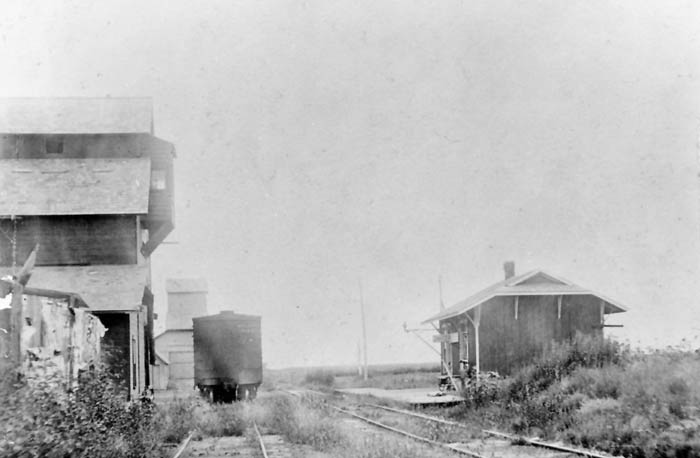
| Palestine | 1871-1873 |
 Depot and elevator. Palestine was a station on the Midland Valley Railroad. It was four and a half miles north and two and a half miles west of Oxford at 1500 E. 60th Ave North. |
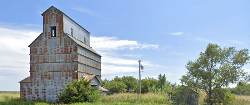
| Paton | None |
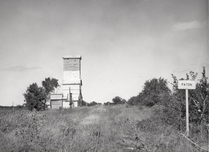 Paton, KS Railroad Board. Paton was on the Texas & Pacific Railway Company & the Midland Valley Railroad. |
| Perth | 1882-1954 |
 Silos in Perth. It was located in Downs Township on the Atchison, Topeka & Santa Fe, and the Chicago and Rock Island Railroads, 12 miles southwest of Wellington. In 1910, it had a bank, two milling companies, several retail establishments, express and telegraph offices, a money order post office with one rural route, and a population of 150. |
| Pontoon | 1879-1880 | It was located on the Ninnescah River, in the center of the northern boundary line of Sumner County. In 1880, it received weekly mail. It was 15 miles from Wellington and an equal distance from Belle Plaine. |
| Portland | 1886-1940 |
 ATS&F Depot, Portland, KS. It was located in Guelph Township on the Kansas Southwestern Railroad 15 miles southeast of Wellington. In 1910, it had a mill, about a dozen retail stores, a telegraph and express office, a money order post office with one rural route, and a population of 69. |
| Purcell | 1885-1887 | The post office moved to Anson. |
| Rex | None |
 Union Pacific Railroad sign. Established in about 1910, it was 9 1/2 miles south, 2 miles west of Argonia at 1100 South Creek Rd. |
| Riverdale | 1887-1973 |
 Old Riverdale building. It was located on the Chicago and Rock Island and the Missouri Pacific Railroads eight miles north of Wellington. In 1910, it had telegraph and express offices, a local retail trade, a money order post office, and a population of 50. It still has several homes and a small population. It is located at the intersection of N Sand Plum Rd and 77th Ave N, or west of U.S. Route 81 next to the railroad. A railroad passes through the community, north to south, from Wichita to Wellington. Previously, another railroad passed through the community, east to west, from Belle Plaine to Conway Springs. It still has several homes and grain silos. |
| Rome | 1874-1933 | Rome was located in Jackson Township. In 1880, the township had about 550 inhabitants, several district schools, and church societies. A stagecoach line ran to Wellington and Caldwell; mail was delivered daily. At that time, Wellington was the most accessible shipping point and nearest bank location. By 1910, it was on the Atchison, Topeka & Santa Fe Railroad. It had a post office, an express office, three milling companies, a bank, several retail establishments, and a population of 82. It was seven miles due south of Wellington. |
| Roy | 1879-1886 | Roy was a post office for a farming community in the western central part of the county. In 1880, it had a Methodist Episcopal Church, a public school, weekly mail, and a Justice of the Peace. It was 25 miles from Wellington, the most accessible shipping point. |
| Salt City/Remanto | 1872-1885 | Near the Arkansas River, in Walton Township, in the southeastern part of the county, this place was initially called Remanto. On October 26, 1874, the name changed from Remanto to Salt City. In 1880, the hamlet had 60 inhabitants, a public school, Methodist, United Brethren, and Christian societies, a drug store, two general stores, a meat market, a hotel, a bathhouse, salt works, a blacksmith, and a justice of the peace. Wheat, corn, and pork are shipped, and daily mail stages ran to Winfield, Wellington, and Arkansas City. It was 16 miles southwest of Winfield, its nearest shipping point, and eight miles southeast of Arkansas City, the nearest bank. The village was immediately north of Geuda Springs at 120th Street South and the Cowley Line. |
| Salt Springs | None | Established in about 1878, it was five miles south of Oxford at 60th Street South and Oxford Road. |
| Slate Creek | 1877-1878 | |
| Spring Dell | 1879-1880 | The post office was only open for about nine months. |
| Sumner | 1871-1882 | Sumner was a country post office 12 miles northwest of Wellington, the nearest shipping point. In 1880, it had a school, tri-weekly mail delivery, a justice of the peace, a Presbyterian minister, and a blacksmith. It was two and a half miles south and a half miles east of Anson along Slate Creek at 50th Ave North at Slate Creek. |
| Sunny Slope | 1877-1884 | Sunny Slope was located in Illinois Township, in the northern part of the county. In 1880, it had a Presbyterian Church, a district school, weekly mail delivery, a general store, a blacksmith, a dentist, a doctor, a constable, and 100 residents. Its shipping point and bank location was 20 miles northwest of Wellington. It was two miles east and two miles north of Conway Springs at Chikaskia Rd and 110th Ave North. |
| Sunset | 1880-1888 | It was five miles west of Conway Springs at 90th Ave North and Dixon Road. |
| Swedona/Belinda | 1877-1885 | When this place was initially settled, it was briefly called Belinda. On June 5, 1877, the name changed from Belinda to Swedona. It was located in Sumner Township and had Dunkard and United Brethren societies, a district school, a general store, semi-weekly mail delivery, and a justice of the peace in 1880. It was 12 miles northwest of Wellington, the most accessible shipping point and bank location. The townsite was one and a half miles east and four miles south of Conway Springs on 50th Ave North between Chikaskia and Caldwell Road. |
| Valverd | 1885-1886 | The post office was open for less than five months. |
| Whitman | 1890-1907 | In 1910, Whitman was a station on the Missouri Pacific Railroad 13 miles northeast of Wellington and five miles southeast of Belle Plaine, from which place it received its mail by rural delivery. The population in 1910 was 25. The old townsite was three and a half miles north and one mile west of Oxford at 1600 E. 50th Ave North. |
| Zyba | 1887-1906 | The post office moved from Dublin. Zyba was a Chicago and Rock Island Railroad station 12 miles north of Wellington. The population in 1910 was 27. It was three miles south and one mile west of Peck on 1200 North West Road. |
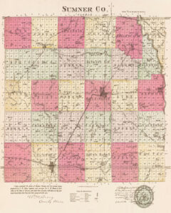
Sumner County, Kansas by L.H. Everts & Co, 1887.
©Kathy Alexander/Legends of Kansas, updated December 2024.
Also See:
Sources:
Blackmar, Frank W.; Kansas: A Cyclopedia of State History, Vol I; Standard Publishing Company, Chicago, IL 1912.
Kansas Post Offices
1880-1881 Kansas State Gazetteer and Business Directory