
A dusty road in Ford County, Kansas, in the 1930s.
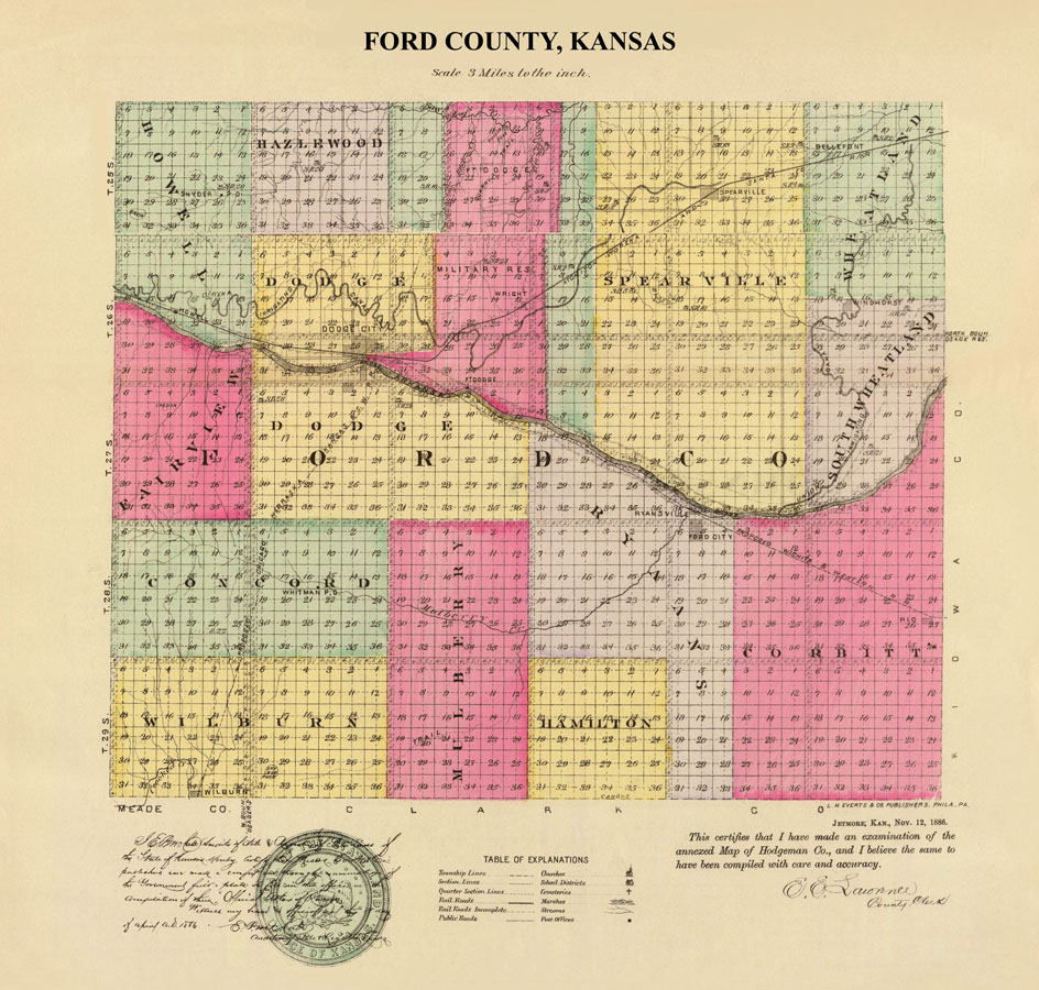
Ford County Map by L.H. Everts & Co., 1887.
| Town | Post Office Dates | Additional Information |
| Bellefont | 1878-1896 1904-1957 |
Planners of Bellefont hoped it would be a railhead and an important junction for the Atchison, Topeka & Santa Fe Railroad. However, that didn’t happen. Today, there are but a few farms and a grain elevator. |
| Corbitt or Corbett | 1885-1887 | Located on the Cannonball Stage Route from Wichita, Corbitt was located just two miles north of Bucklin. Only 3-4 homes were built there when the railroad went to Bucklin. |
| Crooked Creek | 1870-1886 | |
| Eugene | 1886-1887 | |
| Fonda | 1885-1890 | Fonda, located north of Corbitt, was a proposed station on the Wichita and Dodge City Railroad. Vacated 1895. |
| Fort Atkinson | 1851-1853 | Established in 1850, abandoned in 1854. Six miles west of Dodge City on the Santa Fe Trail. |
| Fort Mann | 1845 | Fort Mann was located on the Santa Fe Trail just a few miles west of present-day Dodge City, Kansas. |
| Hazelwood | 1878-1879 | |
| Howell/Morris | 1895-1897 1909-1916 |
Known initially as Morrison Station, the town was yet another railroad stop. The boom years were the 1880s and early 1890s, when the population reached 150. All that is left today is a grain elevator and a county rural fire station. |
| Lasker | 1886-1887 | A short-lived Jewish community that hoped to establish a utopian town. |
| Manila | 1898-1899 | |
| Morrison | 1886-1888 | |
| Newkirk/Colcord | 1887-1888 | The town name changed from Colcord to Newkirk in 1887. The post office moved to Kingsdown in 1888. |
| Noland or Nolan | 1887-1893 | Started around 1882 as a country store and later gained a post office. |
| Reinert | 1908-1917 | Reinert was a country post office located 15 miles southwest of Dodge City. |
| Ricka | 1885-1886 | |
| Sawlog Crossing | None | Located on the Fort Hays-Fort Dodge Military Road, this crossing of Sawlog Creek was in northern Ford County. It was 13 miles south of Buckner Creek. It was initially identified as the South Branch of the Pawnee and named Schaff’s Branch in honor of Lieutenant John Schaff, who was then stationed at Fort Atkinson. The creek’s name was later changed to Sawlog because of the vast timber that lined its banks and furnished Forts Mann, Atkinson, and Dodge with wood for fuel and construction. It was the site of a trading ranch owned by a man named Boyd in 1868. |
| Sears | None | Sears never had more than a telegraph station and a rural schoolhouse. |
| Sidlow | 1885-1886 | |
| Snyder | 1886-1899 | |
| Sodville | None | |
| Sunshine | 1885-1886 | |
| Whitman | 1885-1889 | |
| Wilburn | 1885-1911 | Wilburn was a country post office on the Jones and Plummer Trail in Ford Township. |
| Wilroads | 1909-1922 | |
| Windhorst | 1898-1905 | Windhorst was settled by a German Catholic group in 1895. Although the town no longer exists, its beautiful Immaculate Heart of Mary Catholic Church still stands. |

Ford County, Kansas Map 1899
©Kathy Alexander/Legends of Kansas, updated December 2025.
Also See:
Sources:
Blackmar, Frank W.; Kansas: A Cyclopedia of State History, Vol I; Standard Publishing Company, Chicago, IL 1912.
Kansas Post Office History