
Wilson County, Kansas, landscape near Altoona by Kathy Alexander.
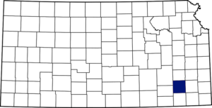
Wilson County, Kansas, location.
Towns & Places:
Coyville – Extinct
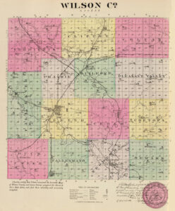
Wilson County, Kansas by L.H. Everts & Co., 1887.
Fredonia – County Seat
New Albany
Wilson County, Kansas, located in the southwest part of the state, was one of the original counties established by the Territorial Legislature in 1855. It was named after Colonel Hiero T. Wilson, a successful Indian trader who had been Fort Scott, Kansas‘ first white settler, serving as postmaster and sutler at the Fort. He could speak Cherokee, Creek, and Osage, and the Osage called him “Big White Chief.” He was a delegate to the Lecompton Constitutional Convention.
As of the 2020 census, the county population was 8,624. Its county seat is Fredonia, and its most populous city is Neodesha.
The county is in the third tier of counties west of Missouri and the second tier north of Oklahoma. It is bounded on the north by Woodson County, east by Neosho, south by Montgomery, and west by Elk and Greenwood Counties. The original boundaries, as fixed by the legislature, included all that is now Montgomery County. However, in 1867, the Free-State Legislature altered these boundaries, and Wilson County assumed its present form.

Verdigris River in Wilson County, Kansas, by Kathy Alexander.
The general surface is an undulating prairie in the eastern portion, broken with mounds and bluffs in the west and timbered hills and canyons in the northwest. In the early years, bottomlands, which constituted 20% of the total area, averaged one mile in width. Springs were abundant, and well water was found at a depth of 25 feet. The principal river is the Verdigris, which enters near the northeast corner and flows southwest and south into Montgomery County. Fall River crosses the western border in the central part and flows southeast, emptying into the Verdigris River near the southeast corner. Two of the principal creeks are Buffalo and Sandy. Occasional disastrous overflows have occurred on the Verdigris River. Limestone, sandstone, Portland cement, graystone, beds of clay, and salt springs were plentiful in different parts of the county.
The territory was included in the Osage reservation and remained free of white occupation until 1865, under the Treaty of Canville. However, settlement began as early as 1857, when adventurous men sought to secure homes in the rich valleys. Henry H. Opdyke, G.J., and William Caven located that year at a point near Coyville, and David Johnson and David Pointer on Buffalo Creek. The following year, a settlement was made in Webster Township on Sandy Creek; John Circle settled on the forks of east and west Buffalo Creeks in the spring and was followed by Peter Welsh and sons, George Gould, Philip Hedrick, and L.F. Woodruff. Lewis F. Davis settled on the Verdigris River and was joined by his brother, Moses, the following year.

Border Ruffians in Kansas by F.O.C. Darley.
N.S. Pigg, Gaston Reeves, and his son Max, John Ross, Jacob Miller, W.W. Wolverton, Frank Sellers, and P.B. Sweet increased the colony near Coyville during the summer and fall of 1857. The following year, John Foreman, James and William Ross, Thomas Sylvester, M.H. Sprague, and Anderson Jones took claims in the same vicinity. By 1860, the census recorded a population of 27, but the number of white settlers at that time likely exceeded 100.
P.B. Sweet taught the first school in the county in Verdigris Township in 1859.
During the Civil War, very little was done in settlement or improvements. At that time, Wilson County was in an exposed position. To the south lay the Indian Territory (Oklahoma) with Indians ready to take advantage of the turmoil; not far beyond lay Texas, full of Confederate enemies; to the west, hostile tribes were awaiting an opportunity to wipe out the settlements, and a few miles to the east were the border ruffians of Missouri. Worst of all, settlers of the county were merely intruders on the holdings of the Osage and were barely tolerated by rightful owners. During the first year of the Civil War, the rebels twice sacked Humboldt in Allen County, and the settlers about Coyville, thinking it would be best to be ready, raised a company of 80 mounted men under the command of Captain John R. Row.

Fort Row in Wilson County, Kansas.
That fall, fortifications were built three miles south of town on land owned by John Shaffer, which was named Fort Row. The insurmountable bank of the river protected one side and the other three sides by blockhouses, each 16 by 24 feet, constructed of heavy logs. Embankments were thrown up on all sides, and the company entered winter quarters. The following spring, the company disbanded, and most of its members joined the Ninth Kansas Volunteers. During the war, the wholesale appropriation of property, especially livestock, led to thousands of head of stolen cattle, which had been driven from Texas, being quartered in Wilson County.
Before the war was over, the county was organized. There seems to have been nothing to call forth such a step amid the turmoil except the ambition of Daniel C. Finn, who came from New York in 1864. There was no taxable property and very few inhabitants. Yet an election was held, in which Finn was chosen as a delegate to the Republican state convention. His efforts resulted in a petition bearing 30 names being presented to Governor Thomas Carney to organize the county. The petition was granted, and a full roster of county officials was appointed, but most of them failed to qualify. The county commissioners were George M. Cottingham, W.M. Asher, and William Brown. A mythical point called Syracuse, supposedly at the center of the county, was designated the county seat. Finn and a town company, numbering 17 men, among whose names appeared that of the governor, attempted to found the town of Syracuse. A log cabin was built at the base of West Mound, and a street was laid off. In April 1865, Finn was notified by the agent of the Osage, on whose land the site was located, to discontinue operations. The first election was held in November 1864, and, it being a presidential year, a full vote might have been expected. However, of the 600 alleged inhabitants of the county, only 26 voted.
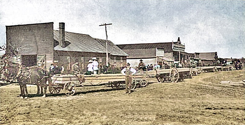
Vintage Coyville, Kansas.
The first election for county officers was held in December 1864. Syracuse received 15 votes for the county seat. The first meeting of the county commissioners of which there is any record was held early in 1867. On March 2 of that year, a petition was presented to the board, signed by 113 voters, asking that an election be called to select a county seat. Accordingly, the election was held in April, and Kalida, a “paper town,” received the majority of votes. Irregularities were discovered in the canvass of the vote, and another election was held on April 30, where Twin Mounds (Fredonia) was chosen as the county seat.
The first post office was established in Coyville in 1866, with Oscar Coy as postmaster.
A third county-seat election was held in May 1869, but no candidate received a majority. In consequence, another was held in June. The contest was between Fredonia and Coyville, with Fredonia prevailing. The question then lay dormant for two years. The growth of several new towns, Neodesha and Altoona in particular, raised the matter again. A ballot was held on May 6, 1871, resulting in no choice; another was held on May 25, in which Fredonia received the majority of the votes. Fraud was detected, resulting in the transfer of the county seat to Neodesha. Fredonia would not give up and brought the matter to court, where she lost. While the case was pending, another election was called in January 1873, resulting in no choice; Neodesha voted for Center. The choice in the second ballot lay between that town and Fredonia, which place was finally triumphant.

St. Louis and San Francisco Railroad depot in Fredonia, Kansas.
The earliest efforts to supply the county with railroads were made in 1871, when bonds were voted in Center and Cedar Townships in the amounts of $50,000 and $35,000, respectively, to aid the Fort Scott, New Chicago & Fredonia Railroad in building through these townships. However, the road was never built. Bonds were voted the following year for the Humboldt & Fredonia and the Missouri & Kansas Southern, neither of which was built. The first road to attempt a fulfillment of a contract was the Memphis & Southern Railroad, which constructed a roadbed from the east line of the county as far as Fredonia. In 1877, bonds were voted for the St. Louis & Kansas Central, but the road was not built. The first railroad built in the county was the St. Louis and San Francisco Railroad in 1879.
The first county fair was held in 1872 in Buffalo.
The first churches in the county were the Methodist, Baptist, and Christian, all organized in the 1870s. The first permanent building was the Neodesha Methodist Church, built in 1873.

Wilson County courthouse in Fredonia, Kansas.
In 1885, a three-story red brick and Native stone courthouse was built by Gauth & Sedley in Fredonia. William R. Parson designed it.
The suggestion that oil and gas were to be found in Wilson County was first made by George W. Chase, a semi-mute who, in 1888, endeavored to interest the citizens of Neodesha in prospecting. In 1892, W. M. Mills, who had developed the gas fields about Osawatomie, secured a franchise and drilled two good-paying wells. He formed a company, from which he later withdrew. However, drilling continued, and numerous wells were subsequently established in the county. They average over 800 feet deep. Both oil and gas were found in abundance.
In 1910, the St. Louis and San Francisco Railroad entered the county near the southeastern corner and ran northwesterly through Neodesha, Fredonia, and New Albany. The Missouri Pacific Railroad entered from the north. It continued to Roper, where it branched: one line went into Montgomery County via Fredonia, and the other via Neodesha. It was built in 1886. The Atchison, Topeka & Santa Fe Railroad entered near the northeast corner and crossed west and southwest through Fredonia into Elk County. This line was built in 1885. A branch of this road from Benedict into Greenwood County was built in 1886.

Wilson County, Kansas, oil wells, 1901.
The county covers 575 square miles, and in 1910, more than 300,000 acres were under cultivation. The value of the farm products for 1910 exceeded $2,000,000, of which corn contributed $500,000. Other leading crops are winter wheat, oats, Irish potatoes, flax, and Kafir-corn. Swine and cattle are extensively raised, and there are more than 120,000 bearing fruit trees, three-fourths of which were apples. The total assessed property valuation in 1910 was 31.5 million. The population was 19,810.
Wilson County’s population peaked in 1920 at 21,157. In the subsequent decades, the population gradually fell.
A new courthouse was built in a modern style from 1968 to 1969. The former courthouse was demolished to make way for the present courthouse. The two-story building, constructed of cream-colored brick and red-brown stack stone, is located at 615 Madison Street in Fredonia. A memorial clock tower, using the original 1885 courthouse clock, is located adjacent to the sidewalk on Monroe Street, on the north side of the courthouse grounds.
Interesting sites within the county include the 1872 Fredonia Arts Council Building and the former County Jail and Sheriff’s Residence.
©Kathy Alexander/Legends of Kansas, updated February 2026.

Wilson County Courthouse in Fredonia, Kansas, by Kathy Alexander.
Also See:
Sources:
Blackmar, Frank W.; Kansas: A Cyclopedia of State History, Vol I; Standard Publishing Company, Chicago, IL 1912.
Cutler, William G.; History of Kansas; A.T. Andreas, Chicago, IL, 1883.
Kansapedia
Wikipedia