
Crawford County, Kansas Coal Mining.
Extinct Towns:
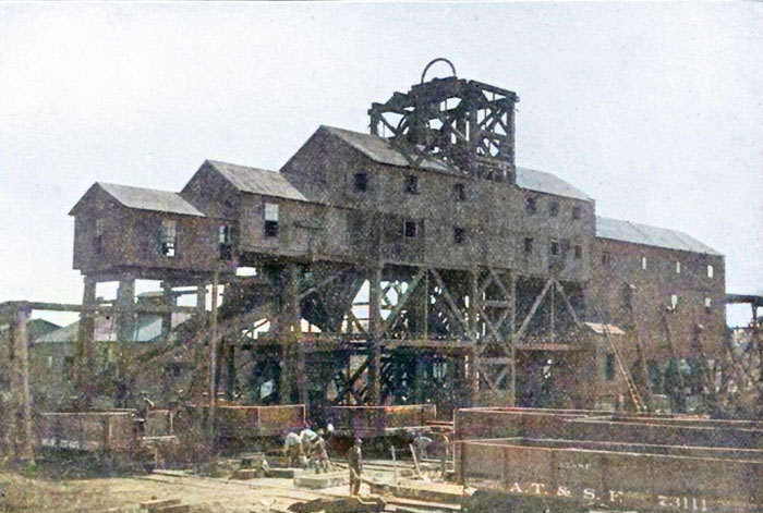
Mount Carmel Coal Company Mine #5, Chicopee, Kansas.
| Town | Post Office Dates | Additional Information |
| 50 Camp | NA |
 50 Camp This mining camp was located about two miles west of Arma. It was a company town of the Central Coal and Coke Company. |
| Base Line | 1870-1872 | |
| Beulah | 1874-1955 | Located in Sheridan Township, the town was founded in 1874 by a Methodist colony. |
| Brazilton | 1882-1966 |
 Store in Brazilton, KS. An unincorporated community in Walnut Township, it was named for Thomas Brazil, a farmer who lived there. The town was a station and shipping point on the Pittsburg & Chanute division of the Atchison, Topeka, and Santa Fe Railway. |
| Breezy Hill | 1916-1919 | Breezy Hill was a small, unincorporated mining camp about two miles east of Arma. It once had many homes, a school, and several businesses.
 Breezy Hill Street  Breezy Hill School |
| Bruce | 1898-1906 | |
| Capaldo | NA | Capaldo was a mining camp located two miles west of Frontenac. The Capaldo Camp was planned on August 29, 1912, by the Cherokee and Pittsburg Coal and Mining Company as a company camp. It was settled that year by Italian immigrants and named for the original owners of the land. Two section roads served as important streets for the company camp. Underground mines of different companies surrounded the camp. In the early 2000s, the community was annexed into the city of Frontenac. Today, it is a neighborhood of homes.
 Jackson & Walker Mine  Capaldo School |
| Cato | 1858-1861 1867-1905 |
Cato, Kansas, was the oldest town in Crawford County. |
| Chicopee | 1892-1918 | Chicopee, Kansas, is a small town in Baker Township of Crawford County that began as a coal mining community. As it no longer has a post office, it is officially an extinct town. As of the 2020 census, the population was 422. |
| Coalvale/Bovard | 1880-1907 | Coalvale, a coal-mining town, was first called Bovard when a post office opened on January 5, 1880. However, a few days later, on January 19, 1880, the name was changed to Coalville. The location was home to the Lewis Coal Company. The post office closed on April 30, 1907. Several homes remain in the area. |
| Crawfordsville | 1867-1873 | Near Girard, established in 1867; abandoned 1869; named for Governor S. J. Crawford. It was Crawford County’s first county seat. |
| Croweburg | 1908-1972 | Croweburg was a station on the Joplin & Pittsburg electric line. |
| Curranville | 1905-1915 | Curranville was incorporated in 1906. In 1910, it was a coal-mining town and a station on the Kansas City Southern Railroad. It was described as a thriving town with a money-order post office, some well-stocked general stores, telephone connections, and a population of 773. Today, nothing is left of the town except for a few scattered homes. It was located about 12 miles east of Girard, Kansas.
 Curranville Street  Curranville School |
| Drywood | 1894-1915 | Drywood was a station on the Missouri River, Fort Scott & Gulf Railroad, in the northern part of Crawford County. It was five miles from Girard, the county seat. |
| Dunkirk | 1915-1919 | Dunkirk was a small, unincorporated mining camp for the Weir Coal Company. It was located two miles west of Franklin.
 Dunkirk Street.  Dunkirk School. |
| Edison | NA | Edison was a mining town located along what is now Highway K-47, about two miles west of US Highway 69. At its peak, the population was about 300. There are currently a few houses in the area.
 Central Coal & Coke Company  Edison Store |
| Englevale/Calvin | 1891-1954 | Originally named Calvin. The town was a stop on the Missouri Pacific Railroad. |
| Farlington | 1870-2018 | Farlington, Kansas, is a small town in Sherman Township of Crawford County. The population was 68 at the 2020 census. The town is also extinct, as its post office closed several years ago. |
| Fleming | 1892-1908 | Fleming was a coal mining town located about six miles southwest of Pittsburg. It was named for Ira Fleming, superintendent of a coal company. At one time, it had a population of about 100.
 Fleming Store  Fleming School |
| Foxtown | NA | Foxtown was a mining camp located two miles east of Franklin. It once had a school, a church, and several business buildings.
Foxtown Street  Foxtown School |
| Fuller | 1894-1914 | Fuller was a coal-mining town with a Kansas City Southern Railroad station. In 1910, it had a money order post office, telegraph and express offices, telephone connections, a good local trade, and a population of 351. It was located ten miles east of Girard. |
| Greenbush | 1874-1901 | The 1881 St. Aloysius Catholic Church at Greenbush has been nicely restored. Next to it are the ruins of the larger 1902 stone church, which burned in 1982. |
| Green Elm | 1872-1894 |
 Green Elm School Green Elm was located on Hickory Creek, about five miles southwest of Idell. It once had a one-room school that held classes from 1872 to 1955 and employed 66 teachers. Though the town is gone today, the school now sits at the Crawford County Historical Museum in Pittsburg. |
| Gross | 1907-1934 | A post office was established on September 28, 1907, and named for the landowners. However, it would be years later before the town was platted. The Gross Camp was established in northeastern Crawford County on December 12, 1914. Section roads served as important streets for the camp. The St. Louis and San Francisco Railroad had spurs to underground mines near Gross. Miners who resided in this non-company camp worked in nearby mines of various coal companies. Gross was the location of Crawford County School #135 and the A.B. Ryder Mercantile Company. There are several scattered homes in the area. The camp was located about five miles southwest of Arcadia.
 Gross Street.  Gross School. |
| Hadley | 1881-1894 | |
| Hamilton | 1868-1871 | |
| Hink | 1889-1894 | |
| Hopefield | 1870-1876 | The Hopefield post office was established in Baker Township in 1871, with J. W. Lane appointed the first Postmaster. It then moved to New Pittsburg. |
| Howe | NA | A small mining community located about 16 miles northeast of Pittsburg.
 Howe Street.  Howe School |
| Idell | 1870-1901 | Idell was situated on Hickory Creek, 12 miles southwest of Girard. C.W. McCloud was its first postmaster. A Catholic Church was located two miles to the northeast. |
| Ingleton/Arnold | 1871-1872 | The name was changed from Arnold to Ingleton on February 26, 1872. Afterward, the post office only remained open for about seven months. |
| Iowa City | 1867 1870-1877 |
Iowa City was situated two miles southeast of Pittsburg. The post office was only open for less than two months the first time. At that time, it contained only a store and a residence, both owned by Isaac Hobson, who came to the area in the fall of 1866. It must have grown some afterward, as the post office reopened in 1870 but closed again in 1877. |
| Kirkwood | NA | The coal mining camp was named for Archie B. Kirkwood, a co-owner of the Wear Coal Company and the Crowe Coal Company. In 1891, John Anderson opened a gin shaft southeast of Pittsburg. In 1892, Archie Kirkwood and Frank Wear purchased the Anderson shaft. They began operations on August 1, calling the shaft No. 2. The Wear Coal Company was then organized and commenced operations. Soon, it opened and operated 12 shafts. |
| La Coy | 1876-1883 | The post office was moved from Strongstown. |
| Litchfield | 1878-1903 | Litchfield, Kansas, was a busy coal-mining town on Carbon Creek |
| Lone Oak | 1884-1886 | A coal mining camp northwest of Pittsburg on the other side of Cow Creek. Guss Johnston arrived from Topeka and sunk the Lone Oak shaft. In 1885, a mining accident in the Lone Oak Coal Company shaft killed two miners and injured four more. In the end, the shaft was not a success. Though the coal was fine, it failed due to the faulty construction of the mine. The pillars had been left too small, and before long, the mine commenced to “squeeze,” the roof settled in, and work had to be abandoned. Others who came afterward also failed, and the railroad company then pulled up the switches, and the mine was abandoned. Afterward, the houses were gradually moved away. |
| Midway/Nyack | 1871-1878 1886-1912 |
In the earlier days of the county, this place was a station on the old stage route known as “Holes-in-the-Prairie.” After the Civil War, a settlement was established along the Cherryvale Division of the Kansas City, Fort Scott & Gulf Railroad. This mining camp was called Nyack when a post office opened in 1871. It closed in 1878. When the post office reopened in 1886, its name was changed to Midway for its geographical position between Fort Scott and Baxter Springs. Midway was located in the eastern part of the county. |
| Mount Carmel | 1871-1895 | |
| Monmouth | 1866-1955 | Monmouth is located in southwest Crawford County. Today, little remains but scattered houses. However, the Trinity Holiness Church remains open. It is located about five miles northeast of McCune on E 516th Avenue. |
| Nelson | 1895-1905 | |
| Osborn | 1867-1872 | |
| Ringo | 1915-1957 | Ringo, Kansas, was a coal mining camp in central Crawford County. As a census-designated place, it had a population of 111 in the 2020 census. The town was named for the owners of the land on which shaft mines were sunk. A post office was established on May 29, 1915. It closed on February 8, 1957. Today, Ringo is a small grouping of houses one mile south and three miles west of Franklin. Chicken Annie’s Girard is just half a mile north of Ringo, at E. 620th Avenue and N. 190th Street.
 Ringo Street  Ringo Mine & Washhouse |
| Strongstown | 1873-1876 | The post office was established in 1873 with C. H. Strong as the first Postmaster. When the post office closed, it then moved to La Coy. |
| Time | 1875-1878 | The post office moved to McCune. |
| Wilkie | 1885-1886 | |
| Yale | 1892-1914 | Yale was a mining town located in Washington Township on the Missouri Pacific Railroad. In 1910, it had general stores, telephone connections, telegraph and express offices, boarding houses, an international money order post office, and a population of 862. The community still has several homes, as well as the world-famous Chicken Mary’s and Chicken Annie’s restaurants. It is located 13 miles southeast of Girard.
 Yale Street  Yale Baptist Church |
©Kathy Alexander/Legends of Kansas, updated September 2025.
Also See:
Sources:
Blackmar, Frank W.; Kansas: A Cyclopedia of State History, Vol I; Standard Publishing Company, Chicago, IL 1912.
Cutler, William G.; History of Kansas; A. T. Andreas, Chicago, IL, 1883.
Home Authors: A Twentieth Century History and Biographical Record of Crawford County, KS, Lewis Publishing Company, Chicago, IL, 1905.
Kansas Post Office History
Pittsburg Memories