| Town | Post Office Dates | Additional Information |
| Alcolia | 1874 | It was located southwest of Eureka. |
| Barry | 1874-1903 | Established in Coffey County (site moved). |
| Belle Grove | 1870-1872 | The post office moved to Climax. |
| Boaz | 1882-1883 | |
| Brigham | 1890-1893 | |
| Burnt Creek | 1873-1874 | |
| Carroll | 1887-1903 | A small community located 12 miles southeast of Eureka and 10 miles west of Toronto. |
| Charleston | 1873-1884 | The post office moved from Fall River. |
| Christiana | 1872-1873 1874-1876 |
|
| Collins | 1870-1883 | The name changed to Reece. |
| Derry | 1883-1896 | |
| Fame | 1868 1870-1920 |
A country post office located ten miles east of Eureka and five miles from Neal. |
| Flint Ridge | 1874-1921 | Also spelled Flintridge, it was a country post office in Salem Township, 20 miles northwest of Eureka. The population in 1910 was 14. |
| Gould/Valley | 1870-1882 | The name changed from Valley in 1880. The name changed to Severy in 1882. |
| Greenwood City | 1884-1887 | |
| Hickman | 1883-1895 | |
| Hilltop | 1884-1951 | A station on the Atchison, Topeka & Santa Fe Railroad, it was located in Shell Rock Township, 29 miles northeast of Eureka. In 1910, it had a population of 50 people, express and telegraph offices, and a money order post office. |
| Homer Creek | 1869-1872 | |
| Inland | 1862-1863 | |
| Ivanpah | 1879-1904 | |
| Janesville | 1860-1880 | |
| Kaiser | 1889-1900 | The post office moved from Twin Falls. |
| Kenbro | 1925-1949 | |
| Kenton | 1872-1879 | The post office moved to Verdigris Falls. |
| Lapland | 1871-1906 | Located in Salem Township, 16 miles northwest of Eureka. The population in 1910 was 20, and when the post office closed in 1906, mail was sent to Flintridge. |
| Lena Valley | 1872-1887 | Established in Greenwood County (site moved). |
| Line | 1878-1879 | Established in Lyon County (site moved). |
| Northward | 1871-1875 | |
| Pleasant Grove | 1857-1874 | |
| Provo | 1897-1901 | A hamlet in the eastern part of Greenwood County. After its post office closed, it received its mail by rural route from Neal, the nearest railroad station. |
| Richeyville | 1882-1883 | |
| Ruweda | 1888-1921 | A country post office in the northwestern part of the county, 18 miles from Eureka and 15 miles from Hamilton, the nearest railroad station. |
| Sallyards | 1918-1943 | |
| Salt Springs | 1867-1873 | |
| Shell Rock | 1873-1883 | |
| Shell Rock Falls | 1860-1865 | Established in Madison County. |
| Sheridan | 1867-1869 | |
| Star | 1889-1903 | An inland village, it was located about 10 miles southwest of Eureka and about 8 or 9 miles northwest of Piedmont, from which it received its mail after its post office closed. |
| Stoughton | 1887 | |
| Teterville | 1927-1962 |
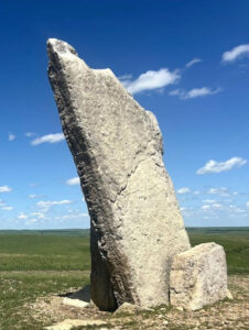
Teterville was an oil town in Greenwood County, approximately 11 miles east of Cassoday. It was founded as an “oil town” sometime after the Teeter Oil Field was discovered around 1920. The oil field was named in honor of James Teter, who owned about 6,900 acres of land. A post office was opened in Teterville in 1927, and after the Teter Oil Fields played out, the town faded away. Its post office was discontinued in 1962. No buildings remain in this former community, but Teter Rock marks the spot. Long before the town was established, James Wesley Teter owned this land in the 1880s. Here, he erected a pile of local rocks at a high point on his land as a guidepost for homesteaders searching for the Cottonwood River. At that time, homesteaders passing through the area en route to their claims on the Cottonwood often became lost in the area’s rolling hills. As the neighborhood of Teterville grew, the rocks were used to construct several buildings, and the Teter marker disappeared. In 1854, the Greenwood County Historical Society reconstructed Teter Rock to replace the earlier landmark in honor of Mr. Teter. The16 foot-upended limestone monolith juts unexpectedly into the endless blue sky of the Flint Hills. Located at the crest of the highest hill in the area, it’s visible for miles in all directions. It is located 0.9 miles south of Teterhill Road on top of a hill. It is accessible by the public using a rural road on private land, so please respect the property. |
| Thrall | 1885-1905 1926-1962 |
An inland hamlet located about 20 miles north of Eureka and seven west of Hamilton, the nearest railroad station and shipping point. |
| Tonovay | 1886-1912 | A hamlet located on the Missouri Pacific Railroad in Bachelor Township, eight miles east of Eureka. In 1910, it had an express office and was a trading point for the neighborhood. Its population was about 25. |
| Triumph | 1878 | |
| Twin Falls | 1870-1899 | The post office moved to Kaiser. |
| Utopia | 1880-1935 | A hamlet on the Atchison, Topeka & Santa Fe Railroad 8 miles northeast of Eureka. In 1910, there was a money order post office and a population of about 30. |
| Verdigris Falls | 1863-1872 1879-1880 |
The post office moved from Kenton in 1879. |
| Willow Valley | 1871-1887 |
Compiled and edited by Kathy Alexander/Legends of Kansas, updated November 2024.
Also See:


