
Jackson County, Kansas barn by Kathy Alexander.

Jackson County, Kansas Location.
Delia – Extinct
Holton – County Seat
Hoyt
Mayetta

Jackson County, Kansas by L.H. Everts & Co., 1887.
Netawaka
Whiting
Extinct Towns of Jackson County
Banner Creek Reservoir
Halfday Creek
The Lane Trail
Nebo State Fishing Lake
Pottawatomi Mission Boarding School
Prairie Band Potawatomi Indian Reservation
Prairie Lake
Jackson County, Kansas, was one of the counties created by the first territorial Legislature in 1855. First named Calhoun County for pro-slavery South Carolina Senator John C. Calhoun, it was renamed in 1859 for President Andrew Jackson. As of the 2020 census, the county population was 13,232. The county seat and the most populous city is Holton.
Jackson County is located in the second tier south of Nebraska and the second West of Missouri. It is bounded on the West by Pottawatomie County, on the south by Wabaunsee and Shawnee, on the East by Jefferson and Atchison, and on the North by Nemaha and Brown Counties.

John Charles Fremont by John C. Buttre, 1859.
The first exploration of the region was conducted by Etienne Veniard de Bourgmont and his company of Frenchmen, who traveled in 1724 through Kansas lands to the Padouca Indians. He passed through Jackson County when traveling from a point above Atchison to the Kansas River just West of Shawnee County. The next exploring party was conducted in 1819 by Dr. Thomas Say, who, with four other scientists, went West as far as the Kansas village where Manhattan now stands and, returning, passed through Jackson County on their way to Cow Island near Atchison. Charles Fremont, “the Pathfinder,” passed through in 1843 on his trip to the Rocky Mountains.
The county’s surface consists of undulating plains. The most significant stream is the Big Soldier, which flows from North to south through the western part of the county and empties into the Kansas River. Other streams are Cross Creek, Little Soldier, North and South Cedar Creeks, Straight, Elk, Spring, Bills, and Muddy Creeks.
The boundaries defined by the 1855 Legislature encompassed 1,140 square miles. The county was surveyed in the same year, and a place seven miles from Topeka, near the old Calhoun Bluffs, was made the first county seat.
The settlements within the county’s borders date back to the 1830s when Captain Alley of Kentucky established a trading post on the Kansas River. But settlement within the present borders did not begin until 1855, when the county was divided into three townships, Douglas, Atchison, and Haliday. Franklin Township was formed in 1856; Jefferson in 1858; Grant in 1870; Netawaka in 1871; Whiting, Liberty, and Soldier in 1872; Cedar and Washington in 1873; and Straight Creek, Adrian, and Garfield since then.
The first settlers in Douglas Township came in 1855: John Rippetoe, William Cunningham, David Rice, Josiah Seal, Byron Stewart, J.W. Willard, A.W. Bainbridge, Hugh Piper, and Rufus Rice. The land was not surveyed, and the settlers established their lines by stakes or blazes on trees. They got their mail from Indianola, Ozawkie, or Grasshopper Falls.

Bleeding Kansas Fight.
Cedar Township was settled in 1855 by S.J. Elliott; Jefferson Township in 1854 by Francis Smith; Franklin Township in 1854 by N.D. Lewis; Grant Township in the late 1850s by Peter Dickson, R.P. Hamm, William Cruzan, J.P. Fraidley, John James, S. Stephenson, and T. Keir; Liberty Township was settled at an unspecified date by Missourians and is said to be the county’s oldest settlement. Some of the early settlers were: Charles Bateman, J.B. Parrot, Alfred Fuller, James Piper, W. R. Hodges, and J.W. Taylor; Straight Creek Township in 1855 by J.H. Thompson; Soldier Township in 1857 by William Kline, Henry Rancier, William Knipe, W. Branham, and the Fairbanks; and Washington, Netawaka, and Whiting Townships were not settled until the 1860s.
The first election for county officers was held on October 1, 1855. The first officers were: James Kuykendall, probate judge; J.T. Wilson, sheriff; Anthony Wilson, treasurer; and James Kuykendall, William Alley, and P. P. Beeler, commissioners. James Kuykendall served as probate judge, register of deeds, county clerk, and prosecuting attorney at different times. He was among the county’s early businessmen. Judge S.D first held the District Court. Lecompte on September 24, 1855.

Liberty School in Jackson County, Kansas.
The famous Lane Trail ran through Jackson County, and the “Battle of the Spurs” occurred at Fuller’s Ford on Straight Creek, near one of the stations of the “underground railway.” During the Civil War, Jackson County furnished 175 volunteers, most of whom joined the Eleventh Cavalry, the Fifth Cavalry, and the Eighth Infantry.
New county boundary lines were established in 1857, when the county was organized. The Legislature established the current boundary lines in 1858, when the county seat was permanently located in Holton.
Golden Silvers, a representative in the Legislature in 1858, changed the county’s name from Calhoun to Jackson. The county officials did not recognize the new name until a year later. In 1858, a vote was held to select a new county seat, and Holton received 79 votes, more than any other candidate. The county voted 51-12 in favor of a free-state constitution. The first county courthouse was located in a harness shop.
Before 1859, the county’s schools were funded primarily through private subscriptions. The first school was taught by Miss Harriet Warfield in 1857 in Douglas Township. A log schoolhouse was built the following year, and in 1859, District No. 12 was organized. Mrs. H. S. Hart taught the first school in Jefferson Township; in Grant Township, by E.S. Hulan; in Liberty Township, by Sophia Lattimer; in Straight Creek Township, by James B. Hastings; and the first real schoolhouse was built south of Holton in 1858, out of logs.
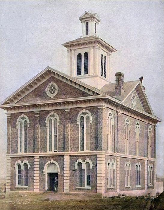
First Jackson County, Kansas Courthouse in Holton, Kansas, 1874.
In 1871, voters approved a proposition to issue $160,000 in bonds to acquire the Kansas Central Railroad. The following year, the county donated its stock to the railroad company. A delay in constructing the road from Holton to the county limits led the company to forfeit all but $60,000 of the funds. This line later became part of the Union Pacific Railroad.
The first courthouse built in the center of the square in 1872 cost $23,000.
In 1910, the Chicago, Rock Island & Pacific Railroad ran from Topeka to Holton, then northeast to Whiting, leaving the county near the northeast corner. The Kansas City Northwestern, a branch of the Missouri Pacific, ran from Valley Falls through Holton and Circleville and North into Nemaha County. Another branch of the Missouri Pacific entered the county from Nemaha and ran through the northeastern part through Netawaka and Whiting. The Topeka & Marysville, a branch of the Union Pacific, was a new road crossing the southwest corner of the county.
In 1910, the county contained 421,120 acres, of which 316,163 were under cultivation. The field crops totaled $2,013,064.78, of which corn accounted for $1,328,664, oats for $210,974, and wheat for $24,351.68. The value of all farm products for that year was $3,322,371.63. Hay crops and Irish potatoes were also extensively raised. There were more than a quarter of a million fruit trees, and the county ranked highly as a fruit-growing locality. It was also known for breeding Thoroughbred stock. One source of wealth was the quarries of white and gray limestone. Brick, clay, and gypsum were found along the creeks.
In 1910, the county had 90 school districts, over 5,000 school-age students, and 60 libraries. The population was 16,861.
The present courthouse was completed in 1921 for $300,000.
The Prairie Band Potawatomi Indian Reservation, near the center of the county, comprises about 18.5% of the county’s area.
©Kathy Alexander/Legends of Kansas, updated July 2026.

Jackson County, Kansas Courthouse in Holton, Kansas.
Also See:
Sources:
Blackmar, Frank W. Kansas: A Cyclopedia of State History, Vol. I. Standard Publishing Company, Chicago, IL, 1912.
Cutler, William G.; History of Kansas; A. T. Andreas, Chicago, IL, 1883.
Wikipedia