
Carbondale Lake in Osage County, Kansas, courtesy of Google Maps.
Towns & Places:
Burlingame
Carbondale
Lyndon – County Seat
Melvern
Olivet
Osage City
Overbrook
Quenemo
Scranton
Vassar – Unincorporated
Melvern Lake & Eisenhower State Park
Pomona Lake State Park
Museums & Historic Sites

Osage County, Kansas Location.

Osage County by L.H. Everts & Co, 1887.
Osage County, Kansas, was created by the first territorial legislature in 1855 and was initially named Weller County. The county was named for Senator John Weller of California, a pro-slavery supporter.
It is the third county west of the Missouri line and centrally located between the Nebraska and Oklahoma state lines. It was not organized until February 1859, when it was renamed Osage. It was changed because of the political leanings of the man for whom it was initially named. Osage County was named for the Osage Tribe.
The surface of Osage County is an undulating prairie. In the early years, excellent-quality coal was found underlying a large portion of the county. It was mined at Osage City, Scranton, Carbondale, Burlingame, and other points. Magnesian limestone was found in the east, blue and gray limestone in the west, and superior quality sandstone in the north. Some flagstone quarried at Osage City was used for paving in Topeka and Emporia. A gray marble capable of taking a high polish was found in the southern townships. There were salt springs along Salt Creek in the south and a mineral spring near Carbondale that was said to possess medicinal qualities.

Shawnee Indian Village.
The northern part of Osage County was formerly a part of the Shawnee Reserve, and the rest belonged to the Sac and Fox Indians. The main line of the Santa Fe Trail crossed the county from east to west, passing through the present city of Burlingame. The Leavenworth branch of this same road crossed the northern part.
The only white men living in the county before 1854 were General Whistler, an ex-army officer and Indian trader, and John Goodell, both of whom had married Indian wives and were living where the Santa Fe Trail crossed 110 Mile Creek, and a man by the name of Case, who kept a trading post at the Indian agency at Quenemo.
On May 30, 1854, John Frele settled with his family near Burlingame, where he purchased land from a Shawnee Indian. His son, born shortly afterward, was the first white child in the county to be born outside the agency.

McGee’s Tavern, 110 Mile Creek, Osage County, Kansas.
In August, I.B. Titus, James, and John Aiken, Alphonso Prentis, and others settled on Switzler Creek. Among these were John Skidmore, William Aiken, John Ward, Hollam Rice, Samuel Devany, and Harry Harvey, who settled on Dragoon Creek. At about the same time, the two McGee brothers, Fry P. and Mabillon, bought out the two early settlers at 110 Mile Creek and established an inn. Moran McGee and C.N. Linkenauger took claims near the mouth of Switzer Creek.
In the fall, agents of the American Settlement Company selected a site for settlement not far from the present town of Burlingame. Among the colonists who came under the auspices of this company were George Bratton, Absalom W. Hoover, Joseph McDonald, James Bothel, William Cable, William Howard, Samuel Allison, J.R. Steward, Marcus J. Rose, and Thomas Black. Only 14 remained through the winter; the others, having no shelter or tools to build, returned east after staking their claims.
In 1855, the population increased significantly through immigration, with the majority settling near Council City and the remainder along the creeks in various parts of the county.

Voting in Kansas.
The election troubles, familiar all over Kansas in 1855, were experienced in Osage County when the Missourians took the polls and elected their candidate, Mabillon McGee, to the legislature. Governor Andrew Reeder ordered another election, and a man named Rice received every vote in his district. A certificate of election was issued to Rice by the governor, but the legislature refused to seat him and admitted McGee in his stead.
Samuel Allison opened the first store in the county at Council City in 1855. The first post office was established about the same time, with Loton Smith as postmaster, and was kept at Allison’s store. The first July 4 celebration was held the same year. The first marriage of record took place in 1860 between John Riffenback and Hannah Thompson. The first school was supported by subscription and was taught in a tent in the spring of 1855 by Miss Louisa Todd. The year 1856 was a severe one for the settlers. Nearly everyone was sick with malaria. Sufficient and suitable food was impossible to obtain, and this, together with a lack of medical aid and proper care, resulted in many deaths, including that of Loton Smith.

Missouri Border Ruffians.
The first military company was organized in 1855 to march to the defense of Lawrence. It was called the “Old Free State Guards.”
In 1856, border disputes began in Osage County and did not end until after the Civil War. The Free Soilers organized another military company in June 1856. A portion of Buford’s company, sent from the southern states to drive the anti-slavery men out of Kansas, camped on 110 Mile Creek, where they remained all summer, making raids, robbing, and committing various outrages. Travel on the Santa Fe Trail was seriously impeded, and getting provisions into the free-state settlements was impossible unless an armed force protected the wagons. On July 4, nearly every man in the settlement went to Topeka to prevent the border ruffians from attacking the free-state legislature, which was to convene that day. After it was dispersed by Colonel Sumner, they returned home.
Most of the claims were taken before the government surveys were conducted, and each settler staked out, as nearly as possible, 240 acres. This caused considerable trouble, as the government allowed only 160 acres. When the surveys were completed, farms were divided in all kinds of shapes, and ownership of the various parcels was difficult to determine. To add to the trouble, many residents could not purchase the land they occupied when the government put it up for sale in 1859. They were obliged to borrow money at interest, which they could not repay, and ultimately lost their holdings. The 1860 drought reduced settlers to starvation, and when they finally raised crops, there was no market for them. In 1859 and again in 1861, the county was struck by severe storms that destroyed substantial property, injured several people, and caused widespread suffering.

Burlingame, Kansas.
The county seat contest, common to nearly all new counties, assumed serious proportions in Osage County. Before the county was organized, voting took place in Burlingame, and no objections were raised. The first meeting of the county commissioners on April 27, 1859, was held at Superior. On June 7, officers were elected.
Coal was discovered near Carbondale in about 1860, influencing the development and route of the Atchison, Topeka & Santa Fe Railroad. However, production would not occur for several years.
The legislature of 1860 appointed a commission to select a location for the county seat. They selected a spot about midway between Superior and Burlingame, which they called Prescott. Prescott was rejected in the April county seat election, and Superior remained the county seat.
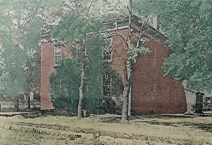
First county courthouse in Burlingame, Kansas. Photo courtesy of John Hill of Burlingame.
In February 1860, Burlingame became the first county seat of Osage County. Philip Schuyler donated the land for the new courthouse, and work began later that same month.
Most of the new immigration was Free-State supporters, and by the time the Civil War broke out, Osage County was overwhelmingly opposed to slavery. During that conflict, Osage County furnished more than its share of soldiers for the Union army. The first enlistment was in May 1861, when 25 men entered the Second Kansas Infantry. Many Osage County men served in the Eleventh Kansas, and many joined the regiments of other states. During the Price Raid, every able-bodied man in Osage County went to the defense of the border. They composed the Santa Fe Road Battalion and were commanded by Colonel M.M. Murdock. The loss of life among Osage County men during that campaign was heavy.
More county seat elections were held in 1861 and 1862, and both resulted in Burlingame being selected as the county seat, where the county records remained for many years.
After a long delay due to the Civil War, the new Osage County courthouse was finished in 1865. The two-story stone building measured 40 by 60 feet.
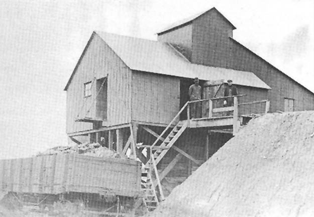
Peterton, Kansas Coal Mine.
Coal production did not occur until at least 1867, when a strip mine was developed near Scranton. The discovery of coal in early 1869 by John F. Dodds at Carbon Hill catalyzed a rapid increase in mining activity. That year, several mines were opened in Osage City and Carbondale, and shortly thereafter, development began at Scranton. Mining at Burlingame was delayed until 1897 because the coal was considerably deeper, and many believed it did not exist.
Before the railroad’s arrival, the market area for Osage coal was quite restricted. Coal at that time was hauled exclusively by wagon, and the market probably did not extend beyond a radius of 40 miles from the mining areas.
On February 20, 1867, Martin William Bates was hanged inside the Osage County courthouse for the murder of Abel Polley. He was the first and only person legally hanged in Osage County
In 1869, the Atchison, Topeka & Santa Fe Railroad penetrated Osage County’s coalfield and continued westward.
When the Sac and Fox Indians moved away, and the entire county was opened to settlement, Burlingame was not centrally located. By the middle of October 1870, there were 120 buildings in Lyndon, of which about 20 were business houses, including two hotels. The population numbered about 500. In October 1870, another county-seat election was held, resulting in Lyndon’s victory. The Burlingame people immediately obtained an injunction to prevent the removal of the county records, marking the beginning of a series of litigation and strife. Although the officers were enjoined from removing the records to the Lyndon, the old site continued to improve for some time, and additions were made. The first church was the Methodist Episcopal, built late in the year.
A private building owned by the Lyndon Town Company served as the first courthouse.
At this time, Osage coal was marketed in a narrow belt that spanned virtually the entire length of the state. No significant competition had been met in the west because the railroad had not yet tapped the Colorado fields of Trinidad and Canon City. The strongest competition was found in Bourbon County. Coal mining greatly stimulated the county’s growth and development. By 1871, the coalfields had become the leading coal-mining center in the state.

Coal miners in Osage County, Kansas.
In subsequent years, more coal fields were developed in other areas of the state and the country, using cleaner-burning, lower-sulfur coal, which led to a rapid decline in coal production after the turn of the century. However, the coalfields of Osage County remained the primary energy source for the Santa Fe Railroad as it expanded to the West Coast and other regions.
In 1865, two bonding propositions for railroads were carried in Osage County — one for the Lawrence & Emporia and the other for the Atchison, Topeka & Santa Fe Railroad. The former was never built, but the latter was completed through the county in 1869 when $150,000 in bonds were issued. The following year, the Lawrence & Carbondale Railroad was built.
Like the rest of the state, Osage County suffered from the grasshopper devastation of 1874.
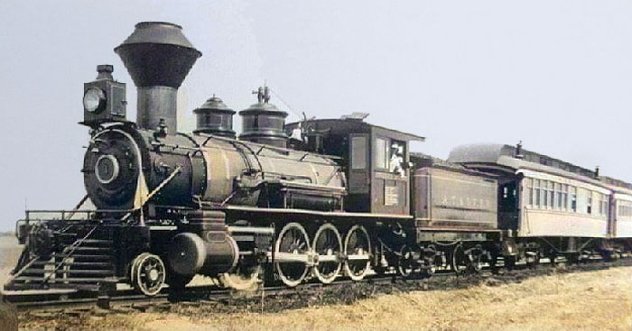
Atchison, Topeka & Santa Fe Railroad in Kansas.
In 1875, the people of Lyndon, who had been trying to obtain the county records for five years, finally resorted to force, and a small armed team was sent to Burlingame to retrieve them. On learning of their approach, the men of Burlingame barricaded the courthouse and prepared to defend it. Scouts were stationed along the road to guard it. The Lyndon men sent out scouts, one or two at a time, to inspect, and all were captured and taken to jail. A force of about 400 from the southern part of the county was then raised at Lyndon and marched to Burlingame, determined to secure the records or burn the town. Scouts sent ahead reported that the courthouse was filled with armed men ready to defend the records. For a time, it appeared as though there would be a battle, as both sides were worked up to a fury. However, wiser counsel prevailed on both sides, and Burlingame surrendered the records, believing that this was the only way to save the town from destruction. Shortly thereafter, the Supreme Court, where the case was pending, affirmed the lower court’s ruling in favor of Lyndon. On March 12, 1878, the county seat was officially and permanently moved from Burlingame to Lyndon after eight years of voting and legal maneuvering. Later that year, Osage County sold the old courthouse to the Burlingame School District for $700.
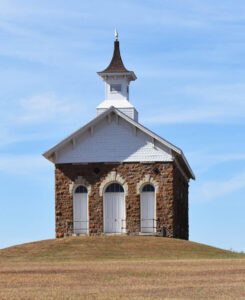
Arvonia School in Osage County, Kansas, by Kathy Alexander.
Various other railroads were projected in the following years, but none were built until 1879, when the Manhattan, Alma & Burlingame Railroad was completed.
In 1910, there were 140 miles of railroad in the county. Corn, oats, and wheat were the leading crops, and livestock was the leading commodity. At that time, the county population was 19,905.
A new Osage County Courthouse was built in Lyndon between 1922 and 1923. It was designed in the Neo-Classical style by William Earl Hulse & Company of Hutchison and built by Montgomery S. Green of Manhattan. Still utilized today, the west-facing building is a three-story structure of buff brick, limestone, and reinforced concrete. Located on spacious, landscaped grounds in the center of Lyndon, the west front has limestone facing on the first story with an arch at the central entrance. Four large columns rise from the second story to a wide header at the top of the third story. In the interior, there is a dual staircase on the west side rising to the third story. The County District Court courtroom is located on the east side of the third story. The building houses the County District Court of the 4th Judicial District, which includes Anderson, Coffey, and Franklin Counties. The courthouse was listed on the National Register of Historic Places in April 2007. It is located at 717 Topeka Street and West 8th Street.
For many years, the major economic forces in Osage County were coal mining, railroading, and farming. As the coal fields were depleted, the railroads followed suit. Farming remains a primary activity, with recreation as a secondary activity, as Pomona Lake and Melvern Lake are located in the county.
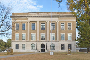
Osage County Courthouse in Lyndon, Kansas, by Kathy Alexander.
The last shaft mine in the state, south of Burlingame, Bell Mine #4, closed in 1964.
As of the 2020 census, the county population was 15,766.
Interesting sites in the county include the Mission Covenant Church, the Arvonia School, the Quenemo Opera House, the Melvern Stone School, the Methodist Mission Building, and the Osage City Santa Fe Railroad Depot.
©Kathy Alexander/Legends of Kansas, updated February 2026.
Also See:
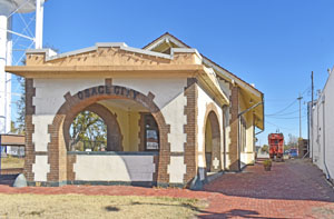
Depot Museum in Osage City, Kansas by Kathy Alexander.
Sources:
American Courthouses
Blackmar, Frank W.; Kansas: A Cyclopedia of State History, Vol I; Standard Publishing Company, Chicago, IL 1912.
Cutler, William G; History of Kansas; A. T. Andreas, Chicago, IL, 1883
Facebook – History of Burlingame, Kansas
Kansapedia
Kansas Historical Society
Osage County