
Many extinct towns in Cherokee County, Kansas, were active during the county’s mining era.
More Extinct Towns:
| Town | Post Office Dates | Additional Information |
| Beaumont | 1879 | The post office originally moved from Lostine. It was only open for seven months. |
| Boston Mills | 1874-1893 | It was located on the Spring River about two miles north of Empire City. |
| Brushville | 1858-1860 1861-1862 1866-1867 |
Brushville was originally settled within the Cherokee Neutral Lands. The area later became part of McGee County before being renamed Cherokee County. The settlement was located west of Riverton. |
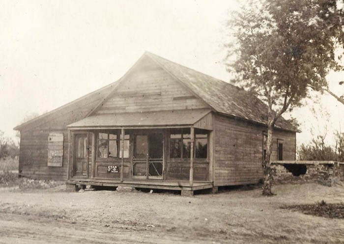
| Carona | 1905-1988 | Carona, Kansas, is an unincorporated community in Ross Township of Cherokee County. It is also an extinct town as its post office has been closed for years. |
| Checo | 1868-1877 | |
| Cherokee | 1883-1885 | |
| Cherokee City | 1860-1862 1867-1870 |
|
| Cherokee Mound | 1869-1870 | |
| Cherry | 1882-1895 | The post office moved to Mineral. |
| Cokedale | 1899-1906 | A small village was located at the junction of the Missouri Pacific and Missouri, Kansas & Texas Railroads, about six miles northwest of Columbus. |
| Crawford Seminary | 1848-1863 | Crawford Seminary, a mission for Quapaw Indians, is believed to have been east of present-day Baxter Springs. Records show that the mission post office was serviced through Missouri. |
| Eldon | 1898-1901 | A little hamlet about eight miles southeast of Columbus and three miles north of Galena. |
| Empire City | 1877-1886 1887-1913 |
Empire City eventually merged with Galena. There are several buildings left in the neighborhood today. |
| Faulkner | 1886-1944 | Faulkner was a shipping point on the Missouri Pacific Railroad about 11 miles southwest of Columbus. In 1910, it had a money order post office, one rural route, telegraph and express services, telephone connections, and several good general stores. It was a trading and shipping point for that portion of the county. At that time, its population was 75. There are still a few area residents and one business called Faulkner Grain. |
| Favor | 1874-1876 | |
| Fly Creek | 1868-1870 | |
| Friendship | 1889-1901 | A small village located on Lightning Creek, 12 miles northwest of Columbus and three miles from Sherman. |
| Fruitland | 1874-1876 | |
| Gregory | 1874 | The post office was only open for two months |
| Hickman | 1872 | The post office was only open for three months. |
| Keelville | 1868-1905 | A small hamlet located in the southwestern corner of the county, 13 miles from Columbus and six miles from Faulkner. In 1910, the population was approximately 45. |
| Kniveton | 1895-1902 | The site was first established in Crawford County and moved in 1895. It was a small village on the Kansas City Southern Railroad, 15 miles northeast of Columbus. |
| Lewiston | 1869-1871 | |
| Lola | 1867-1869 | The post office moved to Millersburg. |
| Lostine-Petersville | 1866-1879 | The name changed from Petersville to Lostine in 1869. Moved to Beaumont in 1879. |
| Lowell | 1868-1905 | It was located on the St. Louis & San Francisco Railroad, 14 miles southeast of Columbus and about four miles east of Baxter Springs. John Rogers, a Cherokee man, was the first settler to be located here in 1842. A Government Commission selected this site for a fort, but Rogers, who owned the land, asked too much for it, and the post was later relocated to Fort Scott. S. Holroyd started the first store here in 1866. The population in 1910 was 156. |
| Lusk | 1898 | The post office was only open for 11 days. The order of change was rescinded. |
| Mackie | NA | Mackie Camp, also known as 42 Camp, was a coal mining camp located five miles north of Columbus and 1.5 miles west of Highway K-7 in Cherokee County, Kansas. At one time, the community had a population of 160 people.
 General Store in Mackie Mining Camp, Cherokee County, Kansas.  School in Mackie Camp, Cherokee County, Kansas. |
| Melrose | 1877-1905 | It was about 15 miles southwest of Columbus and seven miles from Faulkner. |
| Messer-Brownsville | 1874-1906 | The post office moved from Spring River Falls in 1874 and changed its name from Brownsville to Messer in 1879. Situated on the St. Louis and San Francisco Railroad, it was ten miles east of Columbus and five miles north of Galena. Its population in 1910 was 73. |
| Millersburgh | 1868-1876 | The post office originally moved from Lola. It is located eight miles northwest of Columbus. The district schoolhouse, a log building, was built here in 1866. |
| Mineral | 1895-1925 | The post office originally moved from Cherry. In 1910, Mineral was an incorporated city of the third class and a mining town on the Missouri, Kansas & Texas Railroads. At that time, it had a money order post office. West Mineral, an addition to the original town, had an international money order post office. The combined population of the two towns was 1,170 in 1910. There were all lines of mercantile enterprise, a bank, a newspaper called the Mineral Cities Times, an opera house, an electric railway to Columbus, telegraph and express offices. Mineral was eight miles northwest of Columbus, the county seat. |
| Mineral City | 1898 | The post office was only open for six weeks after the order of change was rescinded. |
| Morton-Bero | 1871-1879 | The name changed from Bero to Morton in 1877. It was about 15 miles southwest of Columbus and 7 miles from Faulkner. |
| Neutral-Brush Creek | 1871-1907 | The name changed from Brush Creek to Neutral in 1883. This small village, situated on the St. Louis & San Francisco Railroad, was seven miles south of Columbus. In 1910, it had a flour mill, a general store, an express office, and a population of 76. |
| Neutral City | 1867-1882 | |
| New Memphis | 1874-1876 | The post office moved to Star Valley. |
| New Windsor-Cheneyville | 1883-1887 | The name changed from Cheneyville to New Windsor in 1885. |
| Newcastle | 1883-1885 | The post office moved to Stippville. |
| Peacock | 1901 | The post office was only open for eight months. |
| Pleasantview-Pleasant View | 1866-1903 | Pleasantview in Pleasant View Township was in the northeast corner of Cherokee County. Although it was briefly the county seat, it is now a lost town. |
| Quakervale | 1880-1887 | |
| Riceville | 1895 | The post office was only open for six months. The order of change was rescinded. |
| Rockwell | 1877-1879 | |
| Roseland | 1902-1918 | Roseland started as a mining camp on the Joplin & Pittsburg electric line. In 1910, it had a money-order post office, a church, a school, an excellent local trade, and a population of 100. It was located eight miles north of Columbus.
 Roseland, Kansas Main Street.  Roseland, Kansas School. |
| Salisbury | 1859-1860 | |
| Sanfordville | 1870-1871 | |
| Scammonville | None | A small coal-mining town located just a mile north of Stilson. |
| Skidmore | 1903-1915 | The Skidmore mining camp was an unincorporated community located seven miles north of Columbus, along what is now Highway K-7. Located on the Joplin & Pittsburg electric line, it was once home to about 300 residents. In 1910, it had a general store, a Baptist Church, a school, a post office, and a population of 75.
 Skidmore, Kansas General Store.  Skidmore, Kansas Baptist Church. |
| Spring City | 1857-1859 | |
| Spring River Falls | 1870-1874 | The post office moved to Brownsville. |
| Star Valley-Starvale | 1876-1898 | The post office originally moved from New Memphis, and the name changed to Star Valley. In 1895, the name was changed to Starvale. It was located in the northwestern part of the county. |
| Stilson-Coalfield | 1872-1886 | The name changed from Coalfield to Stilson in 1876. A small coal-mining town, it was located seven miles north of Columbus on the Kansas City, Fort Scott & Gulf Railroad. |
| Stippville | 1885-1887 1892-1915 |
 Stippeville, Kansas The post office originally moved from Newcastle. This mining town was just 1/2 mile from the Turck Station on the St. Louis and San Francisco Railroad and four miles from Columbus. In 1910, it had a few general stores, a money-order post office, and a population of 200. The Joplin & Pittsburg electric line ran through it at the time. |
| Stone City | 1900-1918 | A mining town located in the northern part of the county, Stone City had a money-order post office and a population of 25 in 1910. The community was rocked on the afternoon of December 13, 1916, when an explosion occurred, taking the lives of 20 men and boys and injuring seven working in the mine that day. |
| Tehama | 1873-1901 | Tehama was located five miles southeast of Columbus and not far from Quaker |
| Treece | 1917-2009 | As of May 2012, the city was abandoned, and most buildings and other facilities had been demolished due to pervasive lead contamination from past mining activities. |
| Turck | 1889-1891 | Turck was a small, unincorporated mining camp located approximately three miles south of Scammon on the old St. Louis and San Francisco Railroad line.
 Store and residence in Turck, Kansas, 1938.  Theater in Turck, Kansas, 1938. |
| Varck | 1881-1906 | It was located on the Spring River and the St. Louis & San Francisco Railroad, 14 miles southeast of Columbus and three miles from Baxter Springs. |
| Whitehall | 1883-1887 | |
| Wilsonville | 1884-1885 |
©Kathy Alexander/Legends of Kansas, updated February 2026.
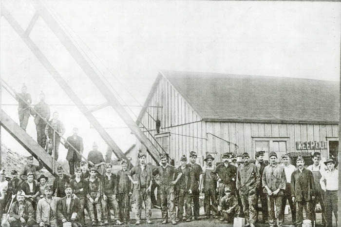
Miners in Roseland, Kansas.
Also See:
Sources:
Blackmar, Frank W.; Kansas: A Cyclopedia of State History, Vol I; Standard Publishing Company, Chicago, IL 1912.
Cutler, William G.; History of Kansas; A.T. Andreas, Chicago, IL, 1883.
Kansas Historical Society Post Office History