
Railroad sign in the extinct town of Selma, Kansas.
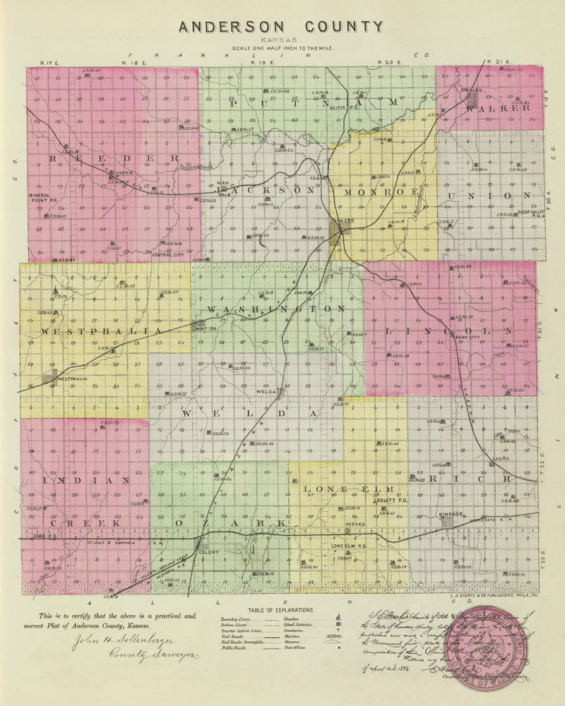
Anderson County, Kansas by L.H. Everts & Co., 1887.
More Extinct Towns:
| Town | Post Office Dates | Additional Information |
| Amiot-Mineral Point | 1862-1951 | This settlement was first called Mineral Point because it was a mound supposed to contain minerals. It was formed in about 1856 and was located in the extreme western part of Anderson County, about 16 miles northwest of Garnett. There are no remains of the town today. |
| Bush City-Haskell | 1880-1956 | Bush City, Kansas, is an unincorporated community in Lincoln township of Anderson County. It is also an extinct town as it no longer has a post office. The name was changed to Bush City on April 19, 1921. |
| Canton | 1858-1866 | B. Tyler located and surveyed Canton in 1857 as a rival to Garnett. For about two years, it was occupied, and some improvements were made, but when Garnett secured the county seat in 1859, Canton was soon abandoned. |
| Central City | 1865-1902 | Located in the southeastern corner of Reeder Township, this settlement was first called Jerome. The first settlers came in June 1857 |
| Cherry Creek | 1861-1867 | |
| Cherry Mound | 1875-1882 | A small country village settled in 1856, located on Cherry Creek in the western part of Anderson County. In 1878, it had a wagonmaker, general store, a blacksmith, and principally explored livestock. It was on the stagecoach line between Neosho Falls and Mineral Point, from which mail was delivered four times weekly to the postmaster James H. Hill. It was 15 miles from Garnett, the county seat and nearest shipping point. |
| Como | 1881-1887 | The post office moved to Northcott. |
| Cresco | 1858-1868 | The Cresco Town Company was formed on May 16, 1857. Late that year, the Town Company erected a steam sawmill on a branch of the Pottawatomie River. |
| Delmont | 1870 | The post office was only open for about eight months. |
| Elizabethtown | 1859-1883 | Elizabethtown, located on Deer Creek in the extreme south of Anderson County, was settled in 1855. The town was founded by Joseph Price, Thomas J. Day, and James A. Dorsey, who formed the Town Company. In 1859, it was surveyed and platted, and a store was soon opened by W. Stubblefield & Co. In 1870, when the Leavenworth, Lawrence & Galveston Railroad came through the area, it was built through the nearby town of Colony, and Elizabethtown’s hopes declined. In 1878, the town had a general store, a physician, and a population of 30. Its mail was delivered semi-weely to J.B. Rhodes, the postmaster, and the community corn and livestock from Colony. Today, all that remains is the Ozark #1 Cemetery. It also had an old one-room schoolhouse for years, but it deteriorated and fell over the years. Often called Liztown by the locals, it was located about 3-4 miles southeast of Colony and eight miles from Garnett, the county seat. |
| Emerald | 1869-1895 1897-1903 |
Emerald was a country post office in the northwest corner of Anderson County. In 1878, it had a Catholic Church and a graded school, and its mail was delivered four times per week to Terence Magrath, the postmaster. Williamsburg was the most convenient shipping point on the Kansas City, Burlington & Santa Fe Railroad. It was 14 miles from Garnett, the county seat. |
| Equity | 1883-1894 | The post office was moved from Rich. |
| Glenloch | 1887-1913 | |
| Harris | 1887-1971 | Harris, Kansas, is an extinct town in Reeder Township of Anderson County, Kansas. It is also a census-designated place. As of the 2020 census, its population was 47. |
| Hyatt | 1857-1867 | Hyatt was formed by a colony in Lawrence, Kansas, who wanted to settle the county. Nothing remains today of what was once the principal town of the county. |
| Indian Valley | 1861 | The post office was only open for about eight months. |
| Lawn | 1899 | The post office was only open for about eight months. |
| Lone Elm | 1879-1956 | Located in Lone Elm Township of southeast Anderson County, it is officially an extinct town because it no longer has a post office. However, as of the 2020 census, its population was 27. |
| Mont Ida/Oneida | 1880-1944 |
 Missouri Pacific Railroad Depot Mont Ida, Kansas, in Washington Township of Anderson County, is an extinct town, as its post office closed decades ago. The town and post office names were changed from Oneida to Mont Ida in February 1881. It is a census-designated place; as of the 2020 census, the area’s population was 23. |
| Mount Gilead-Walker | 1857-1866 | When a post office was established in May 1857, this place was first called Walker. It was surveyed on the opposite side of the Pottawatomie River as a rival town to Greeley. On about September 1, 1857, the Pottawatomie Town Company was organized. On September 11, Rufus Gilpatrick, the president of the town company, presented a plat of a town named Pottawatomie to a notary public. A sawmill was built, and nearly all that existed in Greeley, including the post office, was soon moved to the new town, which grew rapidly for some time. The town’s name was changed from Walker to Mount Gilead on May 20, 1861. However, procuring water for the site was difficult and soon abandoned. When the post office closed in 1866, it was moved to Greeley. By the early 1880s, all that was left was one building used as a granary. It was two miles southwest of Greeley. |
| Northcott | 1887-1906 | The post office moved from Como. |
| Ozark | 1862-1885 | This small hamlet and post office were in the southeastern part of Anderson County, near the border of Allen County. In 1878, it had a population of less than 30. When its post office closed, it was moved to Kincaid. |
| Redes | 1858-1864 | |
| Reeder | 1882 | The post office was only open for about eight months. |
| Rich | 1872-1883. | This place was settled in 1867 on Deer Creek in the southeastern part of Anderson County. In 1878, it had a United Brethren Church, a general store, a physician, and a population of about 40. Its mail was delivered four times weekly to B.F. Reiber, the postmaster from a stagecoach to Colony. It shipped grain, livestock, castor beans, and flax seed from Colony, the nearest railroad station. It was 12 miles from Garnett, the county seat, ten from Colony, and 88 from Topeka. When its post office closed in 1883, it was moved to Equity. |
| Rosyvale | 1860-1862 | |
| Scipio | ||
| Selma | 1887-1956 | Selma was established in Anderson County at the junction of the Kansas, Nebraska, and Dakota and the Missouri, Kansas & Texas Railways in 1887. As it no longer has a post office, it is an extinct town today. |
| Shannon-Cedar Bluff | 1857-1860 | The county seat was established in Cedar Bluff in 1856. In 1857, the town was surveyed by Dr. Preston Bowen, with public parks and with the expectation of its remaining the county seat. More improvements were made, and county buildings commenced. On April 3, 1858, the town’s name was changed to Shannon in honor of Governor Wilson Shannon. However, when the county seat was removed to Garnett in 1859, the townsite was soon abandoned. The post office closed on September 13, 1860, and the townsite became part of a farm. |
| Springfield | 1858-1860 | |
| Sugarvale/Sugar Valley | 1871-1900 | Sugar Valley was located on Sugar Creek in the eastern part of Anderson County. In 1878, it had a Presbyterian Church, a common school, and was on the stage line to Garnett and La Cygne, which delivered semi-weekly mail to Isaac Knouff, the postmaster. The town’s name changed to Sugarvale on September 28, 1894. It was ten miles from Garnett, the county seat and shipping point, and 90 by rail from Topeka. |
© Kathy Alexander/Legends of Kansas, updated October 2024.
Also See:
Sources:
1878 Gazetteer and Business Directory, R. L. Polk & Co., Chicago, IL.
Anderson County Historical Society
Blackmar, Frank W.; Kansas: A Cyclopedia of State History, Vol I; Standard Publishing Company, Chicago, IL 1912.
Cutler, William G; History of Kansas; A. T. Andreas, Chicago, IL, 1883.
Kansas Post Office History
Kansas State Historical Society – Post Offices