
Marion County, Kansas, landscape near Durham by Kathy Alexander.
Towns:
Burns
Durham
Florence
Goessel
Hillsboro
Lehigh
Lincolnville
Lost Springs
Marion – County Seat
Peabody
Ramona
Tampa
One-Room, Country, & Historic Schools of Marion County
Chingawassa Springs
Lyon Creek
Cottonwood River
Whitewater River
Marion County Lake
Marion Reservoir
Butler College of Marion
Tabor College, Hillsboro
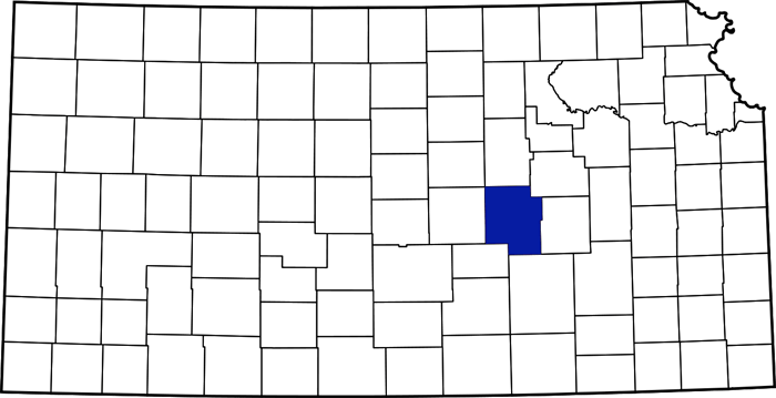
Marion County, Kansas, location.
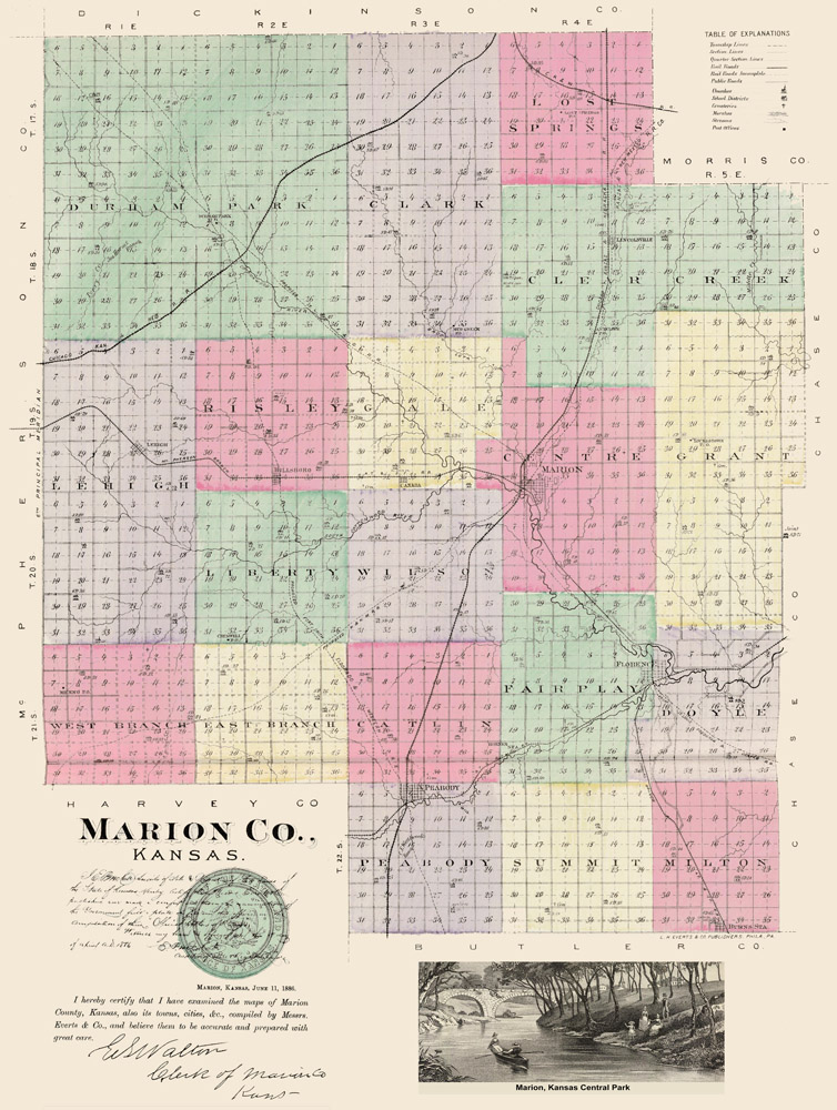
Marion County, Kansas by L.H. Everts & Co., 1887.
Marion County, Kansas, located in the east-central part of the state, was fixed by a legislative act in 1860 and named for General Francis Marion, a Revolutionary War hero. Francis Marion was known as the “Swamp Fox” for his elusive tactics. Leading a guerrilla campaign of raids and skirmishes against the British in South Carolina, he wreaked havoc on British communication and supply lines before withdrawing into the swamps.
The original western boundary of Marion County reached the Kansas–Colorado border, covering more than a third of the state’s area.
In 1806, Zebulon Pike led the Pike Expedition westward from St. Louis, Missouri. Part of their journey followed the Cottonwood River through modern Marion County near the current cities of Florence, Marion, and Durham.
Long before the county was formed, the Santa Fe Trail, established in 1821, made its way through it. This road of commerce, connecting the Missouri River with Santa Fe, New Mexico, was first an international road, and after the Mexican-American War, it became a national road.

Santa Fe Trail, Marion County, Kansas, from Interpretive Panel.
The Santa Fe Trail crossed Marion County from the northeast, passing by Lost Spring to the west of Lehigh before making its way through Tampa, to just west of Durham at the old Cottonwood Crossing, and then southwest into McPherson County.

The area of the spring at Lost Spring, Kansas, by Kathy Alexander.
The first settlers in the county were located on Doyle Creek, near the present town of Florence. They were Moses Shane, who came in 1858 and whose death the following year was the first in the county; Patrick Doyle, in 1859, for whom Doyle Creek and township were named; and a family by the name of Welsh, in which occurred the first birth in the county in August 1859. The same year, Thomas J. Wise settled on Clear Creek, and John Brenot settled on Brenot Creek.
In the spring of 1859, a trading post was established at Lost Spring on the Santa Fe Trail, and in the autumn of the same year, Abraham Atlantic Moore and his older brother, Ira, established Moore’s Ranch near the present town of Durham. The first post office was established there with A.A. Moore as postmaster. Later that year, a post office was established at Lost Spring, with J.H. Costello as postmaster. Previously, the nearest post office was Emporia.
In 1860, William H. Billings, George Griffith, and William Shreve located where the city of Marion now stands. The county’s population was 74 in that year.
A.A. Moore and W.H. Billings opened the first store in Marion County in 1861. The first grist mill was erected in 1872 on the Cottonwood River by Moore & Fuller. The first wheat grown in the county was raised by Silas C. Locklin in 1863. It was threshed by the old treading process used in Bible times and was cleaned by pouring it in the wind. It had to be hauled to a mill near Emporia to be ground, and the hauling was difficult as there were no roads. The first sermon was preached in the schoolhouse. The minister came 45 miles to hold the service, clad in overalls and a woolen shirt.
The settlers were, for many years, in danger from the Indians. In 1864, a man was scalped on the trail at “Cottonwood Holes,” near the headwaters of the Cottonwood River, by a party of Cheyenne and Kiowa. At Marion, a log house was surrounded by a high stone corral used as a fort. A ruling existed among the settlers to the effect that no gun was to be fired unless there was danger from the Indians. Those too far away to get to the “fort” were often hidden in the cornfields, where whole families often remained concealed all night.

Moore’s Ranch at Cottonwood Crossing, Kansas by Doug Holdread, 2005. From the interpretive panel.

The first schoolhouse in Marion County, Kansas.
Marion County was organized on July 6, 1865, by George Griffith, William H. Billins, William P. Shreve, Reuben Riggs, A.E. Case, and A.A. More. The first election was held on August 7, 1865, when 23 votes were polled, and the following officers were elected: William H. Billings, probate judge and county commissioner; Thomas J. Wise, treasurer and county commissioner; Levi Billings, commissioner; R.C. Coble, county clerk and register of deeds; John C. Snow, sheriff; W.P. Shreve, the county surveyor; Reuben Riggs, county attorney. When it was found that Mr. Wise was ineligible for office, A.A. Moore was appointed. The first meeting was held at the home of William H. Billings at Marion, which was made the county seat at the election in December 1866. The first school district, Number 1, was organized in 1865 for the entire county and also included everything west to Colorado and south to present Oklahoma. The first school in the county was taught in the winter of 1865-66 by Dr. J.N. Rodgers of Marion. The district encompassed the entire southwest Kansas, which was once part of the county. The first term lasted four months, and the assessor had to go all the way to the western line of the state to collect taxes to support the school. Some students came from Larned, Fort Dodge, and other remote settlements. The schoolhouse was made of logs with a dirt roof, and the teacher’s desk was a dry-goods box.
In 1866, the railroad reached Junction City. At that time, freight was transferred to wagons, which made their way to Fort Harker, then southwest to rejoin the Santa Fe Trail near the Great Bend of the Arkansas River. Afterward, the Santa Fe Trail was no longer active in Marion County except for local travel.
From 1867 to 1871, the Chisholm Trail was routed along the western edge of Marion County. The trail started in Texas and ended in Abilene, Kansas, where cattle were shipped eastward by rail. The old town of Waldeck was near the junction of the Santa Fe Trail and Chisolm Trail. As the railroads were built westward and southward, the trail was truncated from going further north.
The first two-story stone courthouse was built in 1867. The county appropriated $999 for this building. The upper floor was used for county court purposes, and the first story was used for a school. A high wall made it a place of refuge and defense in the event of an Indian attack. However, it was never needed for that purpose. An addition was completed in 1879.

Cheyenne Warriors.
In the summer of 1868, the Cheyenne Indians committed depredations in the county’s northern portion, with many settlers losing cattle and horses. These were followed by white thieves committing the same offenses in Indian guise. Many settlers went to Marion and sought refuge in the stone building used as a store by J. H. Costello, which stood on the southeast corner of Main and Fifth streets. David Lucas rode to Council Grove and secured relief, which, in all probability, averted an attack.
The Marion Methodist Church was organized in 1869.
The assessed valuation of property in Marion County was $40,000 in 1870. At that time, the county’s population was 768.
The first county fair was held at Peabody on October 13, 1875. The present fair board and system began in 1931 and has conducted an annual fair in Hillsboro.
Beginning in 1870, William Scully of Illinois made large land purchases in Marion County. Once known as America’s “most extensive landholder,” he introduced the Scully land system, which included tenant farming and drain tiling fields. He continued to buy land in Kansas until 1885. By 1900, William Scully had accumulated about 225,000 acres of prime agricultural land in Illinois, Kansas, Missouri, and Nebraska. The Scully estate still owned 53,491 acres in Marion County as late as 1942.
Today, the Scully Estate still owns property in Marion County. On this land is a nearly continuous segment of the Santa Fe Trail. Because Scully utilized the land for cattle grazing, it was never cultivated; it remains virgin prairie and is as close to undisturbed prairie as can be found along the Santa Fe Trail. Beginning on Falcon Road about 0.5 miles south of 280th Road and extending for over three and one-half miles to 250th Road about ¼ mile east of Chisholm Trail Road, it is an almost continuous segment of the trail. This trail segment includes the Durham Blow Out, an area of deep erosion where the trail ascended a hill. Access is not allowed.

Mennonite Home in Marion County in 1890.
The Presbyterians at Marion had the first church building constructed in 1871.
The present boundary lines of the county were finally decided upon in 1872. At that time, it contained 24 townships and encompassed 954 square miles.
In 1874, Russian Mennonites immigrated to the county and purchased vast tracts of government and railroad land.
The first county fair was held at Peabody on October 13, 1875.
A second county seat election was held in 1881, favoring Marion. That year, an appropriation of $5,000 was made, and the original courthouse was remodeled.
The Kansas & Nebraska Company made the first railroad proposition, and the agreement was that $200,000 in bonds should be issued to the company upon completion of the grade to Marion. The grade was completed, and the bonds were issued, but no railroad was built.
In 1907, the present three-story native limestone courthouse in Marion was completed and remains in use today.

Atchison, Topeka & Santa Fe Railroad Depot in Marion, Kansas, 1912.
In 1910, the county’s railroads included the Atchison, Topeka & Santa Fe Railroad and the Chicago, Rock Island & Pacific Railroad. The former’s mainline entered the county’s east line and crossed southwest through Florence and Peabody. A branch diverged northwest, which ran through Marion and Hillsboro, and another branch went south through Burns into Butler County. Another line of the same road crossed the extreme northeast corner, passing through Lost Springs. Two lines of the Chicago, Rock Island & Pacific entered northeast of Herington. One ran south to Marion, then southwest to Peabody and into Butler County; the other cut off the northwest corner, passing through Ramona, Tampa, Durham, and on into McPherson County.
In addition to the public schools, there were three private institutions: the English-American preparatory school at Hillsboro, a German Lutheran school at Lincolnville, and the School of the Immaculate Conception at Burns.
In 1910, the agricultural and stock-raising county ranked among the foremost in the state in the amount of money realized from the sale of stock sold for slaughter. The total value of farm products averaged over $5,000,000 annually. Corn, the heaviest crop, netted $1,500,000 in 1910; oats, $600,000; and animals sold for slaughter nearly $2,000,000. Kafir corn, oats, hay, poultry, butter, and eggs were important products, and there were 200,000 bearing fruit trees.
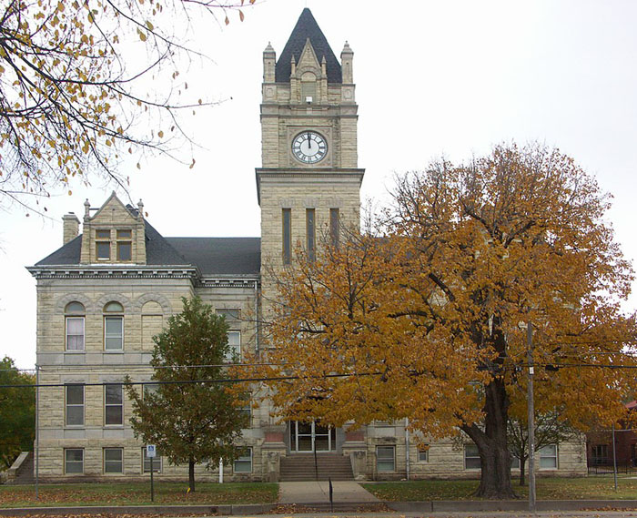
Marion County Courthouse in Marion, Kansas, courtesy Wikipedia.
The assessed valuation of property in 1910 was over $40,000,000. At that time, the county’s population was 22,415.
The National Old Trails Road, also known as the Ocean-to-Ocean Highway, was established in 1912 and was routed through Lehigh, Hillsboro, Marion, and Lost Springs.
Peabody and nearby Watchorn experienced an oil boom from 1918 to 1920. The petroleum industry’s influence remained strong in Peabody, resulting in the greatest change in the community in the shortest time. More than 100 residences were constructed in October and November 1919. From 1918 to 1919, the population increased by 75%, but later decreased as the oil boom in other Kansas areas needed the workers.
Marion County’s population peaked in 1920 at 22,923. In the following decades, the population gradually declined.
The present fair board and system began in 1931 and has conducted an annual fair in Hillsboro.
From 1935 to 1937, Marion County Lake was constructed southeast of Marion.

Marion Reservoir in Marion County, Kansas, by Kathy Alexander.
From 1964 to 1968, the Marion Reservoir was constructed northwest of Marion.
Interesting sites in the county include the Marion County Courthouse and the Elgin House in Marion, the Harvey House in Florence, and the Pioneer Adobe House in Hillsboro, Kansas.
Marion County’s population, as of the 2020 census, was 11,823. Marion remains the county seat, and its most populous city is Hillsboro.
©Kathy Alexander/Legends of Kansas, updated March 2026.
Also See:
Santa Fe Trail in Marion County
Santa Fe Trail – Highway to the Southwest
Sources:
Blackmar, Frank W.; Kansas: A Cyclopedia of State History, Vol I; Standard Publishing Company, Chicago, IL 1912.
Cottonwood Crossing Chapter of the Santa Fe Trail
Kansapedia
Marion County Historical Society
Marion County, Kansas
Wikipedia