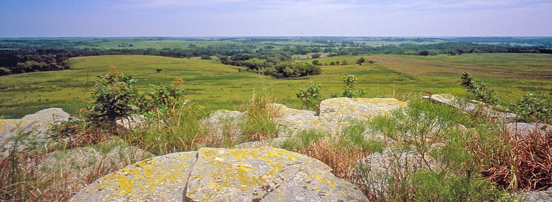
Osage Questas in Greenwood County, Kansas, by the Kansas Geological Survey.
The Osage Cuestas region covers much of eastern Kansas south of the Kansas River. It is a gently undulating cuesta plain composed of several alternating sandstone, limestone, and shale layers.
Cuesta (pronounced Kwesta), Spanish for “hill” or “cliff,” is the term geologists use to describe ridges with steep, cliff-like faces on one side and gentle slopes on the other. Cuestas are characterized by east-facing ridges up to 200 feet high. Various other landscapes, from relatively flat plains to rolling hills, also occur.
The topography is distinct from the more dramatic rolling hills of the Flint Hills to the west. Potential natural vegetation ranges from predominantly tallgrass prairie in the west to a mixture of tallgrass prairie and oak-hickory forest in the east, with floodplain forests along the streams. The moist, silty clay loams are formed from material weathered from limestone and shale, and they support a land-use composite of cropland, woodland, and grassland/rangeland.
This region comprises all or parts of Shawnee, Douglas, Johnson, Lyon, Osage, Franklin, Miami, Coffey, Anderson, Linn, Greenwood, Woodson, Allen, Bourbon, Elk, Wilson, Neosho, Crawford, Chautaugua, Montgomery, Labette, and Cherokee Counties.
Most rocks at or near the surface, including fossil-laden limestone and shale, were formed in sediments deposited in shallow seas during the Pennsylvanian subperiod about 323 to 299 million years ago. The sea rose and fell in cycles, and the environment changed, so different rocks formed depending on the water’s depth and environmental conditions. Shales formed from clay and silt particles that settled out in deep and still water, and limestones formed from seashells and chemical debris in warm and shallow water. Sandstone outcroppings and coal also occur throughout the region.
When sea levels fell far enough to expose the land, freshwater streams cut deep channels into the limestone and shale in places. They then filled the channels with sand, silt, and other sediments carried in and dumped into the water, as well as fragments of rocks eroded from the channel walls.
Changes within the Earth also uplifted or raised the land in the area. Together, uplift and erosion shaped the cuestas and plains. Sloping gently west or northwest, the cuestas are capped with a resistant layer of limestone that protects the underlying shales and limestones from erosion. Where shales were nearest the surface, the shales eroded more readily, and large expanses between cuestas developed into plains.
Moist, silty clay prevails throughout most of the region. The eastern edge of the Osage Cuestas transitions between hardwood forest and tallgrass prairie. Cropland and grassland cover most of the region, although trees are along the streams.
The region is home to a remarkable variety of wildlife. Hunters are interested in doves, turkeys, squirrels, and white-tailed deer, while fishermen are attracted to catfish, crappie, and white bass. Wildlife viewers see a variety of birds passing throughout the region, and lakes attract ospreys and waterfowl. The woods are home to woodpeckers and owls, and the prairies have nighthawks and grassland sparrows. Muskrats, beavers, and coyotes are also plentiful.
Water is abundant throughout the region. Numerous reservoirs contain most of the water supply for this part of Kansas. The annual precipitation averages from over 40 inches near Fort Scott to about 35 inches near Emporia. The eastern edge of the Osage Cuestas transitions between hardwood forest and tallgrass prairie. Cropland and grassland cover most of the region, although trees are also found along streams.
Compiled & edited by Kathy Alexander/Legends of Kansas, updated April 2025.
Also See:
Sources:

