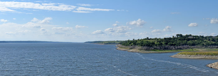
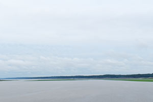
Tuttle Creek Lake is a reservoir on the Big Blue River five miles north of Manhattan, Kansas. Located in the Flint Hills of northeast Kansas, it was built and operated by the Army Corps of Engineers primarily for flood control.
Though 25 floods damaged the area and cities downstream between 1903 and 1959, there was much opposition to building the dam that created the lake.
The Kansas River Valley has experienced significant flooding throughout history. A flood in 1844 affected Kanza and Osage villages and some Indian missions.
In 1903, a significant flood severely impacted the citizens of Manhattan, Topeka, Lawrence, and Kansas City.
In 1935, the Kansas River once again flooded. Afterward, the U.S. Army Corps of Engineers recommended building seven dams and reservoirs throughout the Missouri River Basin, including Tuttle Creek. Though these flood control dams would protect residents and businesses and provide work for the hundreds of unemployed workers during the Great Depression, no money was appropriated.
In 1938, the U.S. Congress proposed building Tuttle Creek Reservoir again. In 1944, Congress authorized the Flood Control Act, which called for a series of large dams and levees on rivers in the basin, including Tuttle Creek. However, nothing was done.
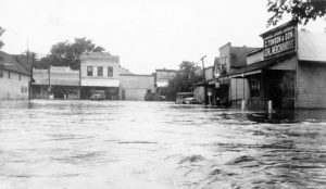
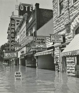
On July 13, 1951, the single greatest day of flood destruction occurred in Kansas. These record-breaking floods, called “Black Friday,” initially hit Fort Riley and Manhattan, smashing the army barracks at the fort and leaving Manhattan’s business district in eight feet deep water. The Kansas River was so full that it forced the waters in its tributary, the Blue River, to run backward.
In the Kansas City area, the Kansas River poured over levees, causing the evacuation of 15,000 people. Homes, railroad yards, stockyards, packing plants, warehouses, and manufacturing plants were damaged. The damage across eastern Kansas and Missouri exceeded $935 million, killed 28 people, and displaced 518,000 more.
After this flood, the Corps of Engineers planned to build a network of major reservoirs on rivers across Kansas and other Missouri River basin states. From 1948 to 1981, the Army Corps completed 21 significant dams on Kansas waterways, drastically altering the landscape that the 19th-century farmers had homesteaded. Tuttle Creek alone covered 12,350 acres.
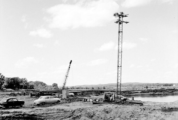
Construction of the Tuttle Creek dam began in 1952, and the government began acquiring the surrounding farmland. Although building the dam and reservoir would disrupt the lives of citizens in ten Kansas communities, without its protection, the potential damage during a flood to cities and towns downstream could amount to millions of acres of flooded cropland, transportation facilities paralyzed, and businesses destroyed.
“We again walk in perilous times. It would seem that those outside our area would send us to a watery grave.”
— Mariadahl Pastor Gustafson
However, local landowners strongly opposed the project. It would displace 3,000 people and ten towns, including Stockdale, Randolph, Winkler, Cleburne, Irving, Blue Rapids, Shroyer, Garrison, Barrett, and Bigelow.
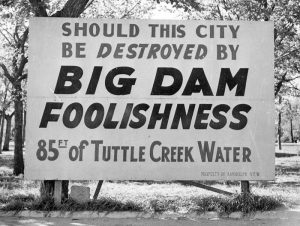
The citizens of the Blue River Valley, north of Manhattan, soon began a campaign to save their farms, many of which had been in the valley for generations. Though everyone agreed flood protection was desperately needed in Kansas, the disagreement lay with constructing a large reservoir in prime farmland. Labeling the Tuttle Creek Dam project as “Big Dam Foolishness,” they were able to delay construction from December 1953 until December 1955 through vigorous campaigning, letter writing, and public debate. However, the Corps of Engineers continued to acquire thousands of acres through purchase and condemnation.
Although the opposition was heated, it failed to stop the building of the dam. The dam was completed on July 1, 1962, and the lake began filling up. Of the ten towns affected, the lake entirely submerged four, including Cleburne, Randolph, Garrison Cross, and Stockdale. After tenuous negotiations, only Randolph and Blue Rapids survived in some physical form. Randolph was the only town to rebuild elsewhere, and the streets are named after the submerged towns.
“Laughter doesn’t come easily, nor often, in the town this summer. Townsfolk talk quietly-almost in hushed voices, as though in respect and sympathy for the town in its death throes.”
— 1959 newspaper article referring to Irving, Kansas
The dam was first tested during a large flood in 1993, when waters reached up to 62 feet, forcing it to reach its maximum capacity in July 1993. As a result, all 18 gates of the spillway were released. Nearby witnesses said the roaring of the waters was so loud it could be heard from more than a half-mile. After releasing water for three weeks, it left an almost 20-foot-deep canyon carved in the ground of the spillway channel.
Today, Tuttle Creek State Park offers visitors a wide variety of outdoor recreation possibilities, including fishing, hunting, boating, and camping. Tuttle Creek Reservoir, the state’s second-largest lake, offers 12,500 acres of water and approximately 100 miles of rugged, wooded shoreline to explore. The park has numerous nature trails, a mountain biking trail, and a scenic equestrian trail that offers explorers various routes to explore the Flint Hills. There is an 18-hole disc golf course, volleyball courts, horseshoe pits, and the state-of-the-art Fancy Creek Shooting Range. Excellent channel cat and flathead fishing are available in the lake and the river above and below the lake. Tuttle Creek State Park is located north of Manhattan, Kansas.
© Kathy Alexander/Legends of Kansas, updated November 2024.
Also See:
Sources:
Kansas Memory
Kansas State Historical Society
Lakepedia
University of Nebraska
Wikipedia

