
An old bridge in Marshall County, Kansas, by Kathy Alexander.
“Years ago, there was scarcely a vestige of civilization in what is now known as Marshall County. For untold ages, its prairies had been covered with a waving sea of wild grasses; vast herds of buffalo had, for numberless years, wandered almost unmolested across them. Nothing disturbed its solitude.”
— William G. Cutler, 1883
Extinct Towns:
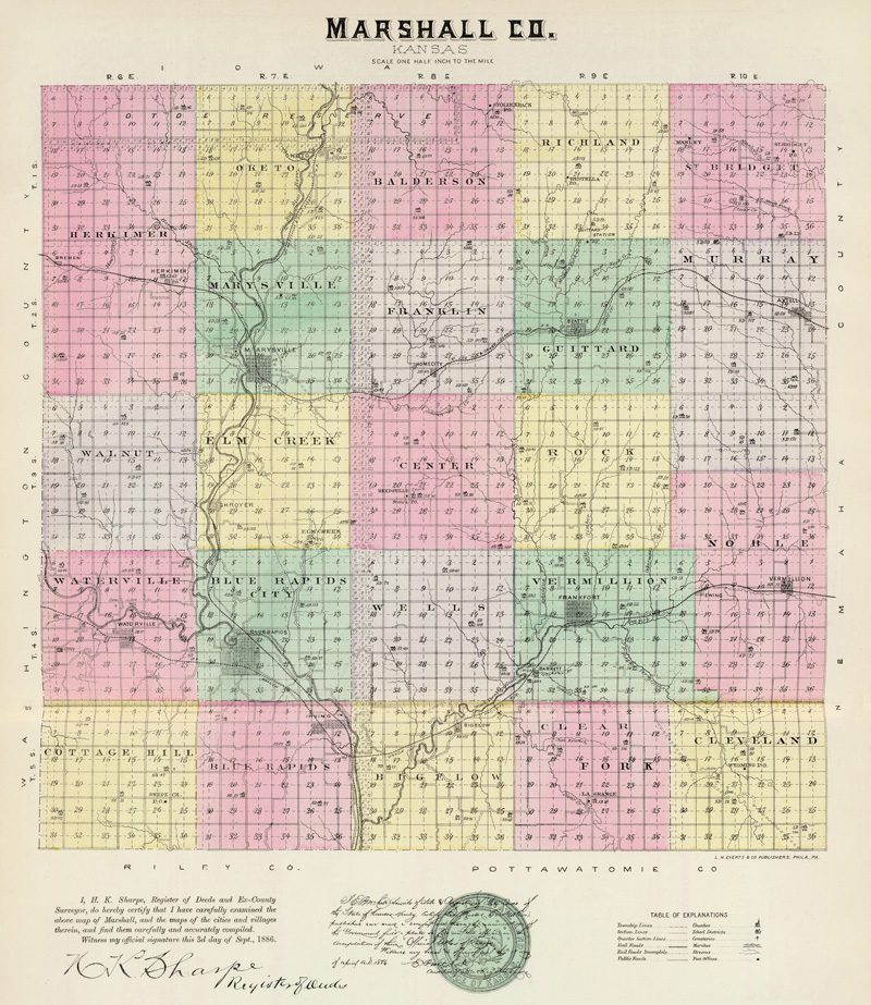
Marshall County, Kansas Map by L.H. Everts & Co., 1887.
“It takes three log houses to make a city in Kansas, but they begin calling it a city as soon as they have staked out the lots.”
— Horace Greeley
More Extinct Towns
| Town | Post Office Dates | Additional Information |
| Afton | 1893-1898 1900-1901 |
Afton was located ten miles southwest of Marysville. |
| Ash Point | None | Ash Point was a stage station on the Overland Trail between Seneca and Guittard Station. It was located a few miles north of where Axtell now stands. |
| Ayersville | None | In 1855, Ayersville, a village or feed station, was 20 miles south of the Nebraska line on the Little Blue River, probably at or near Cedar Falls. |
| Bennett’s Station | 1858-1859 | Probably at the home of Moses Bennett on Coon Creek, where he kept a feed and supply station. |
| Black Vermillion Crossing | None | On the Oregon Trail. Louis Tremble corduroy toll bridge and blacksmith c1850-56. In 1860, it was reported that the Big Vermillion toll bridge tallied an average of 75 wagon trains per day, mostly ox teams. |
| Blanchville | 1871-1879 | The post office, named for Horatio Blanchard, the postmaster and early settler, was located on the northeast corner of section 22 in Walnut township. |
| Cedar Falls | None | It was located 2.5 miles northwest of Waterville on the Little Blue River. In 1858, William Pearsoll built a combination grist and sawmill at Cedar Falls, which Rufus R. Edwards of Marysville later acquired. There is nothing left of this mill. |
| Cottage Hill | None | Cottage Hill was laid out before 1872, but never had a post office. It was located in Section 22 of the Cottage Hill Township. |
| Elizabeth | 1868-1872 | A feed and supply station on the Missouri Pacific Railroad was located one mile northeast of Bigelow near Inman’s Quarries. |
| Elm Creek | 1874-1893 | A post office was located on South Elm Creek at the home of John Means, postmaster and early settler. |
| Ewing | None | Ewing was located three miles west of Vermillion. It was named for the Ewing family. |
| Fairland | 1863-1869 | |
| Gertrude | None | Founded January 2, 1861, vacated 1864. It was one mile northwest of Marysville on the hilltop, west of the mill. It consisted of a small frame house, in which its owner sold “necessaries” to the emigrants. |
| Granite Falls-Marble Falls | None | Established on the Little Blue River near the mouth of Fawn Creek on section 24 in Waterville Township. Marble Falls was established in 1867 by Judge Lewis, father of Mrs. E. A. Berry of Waterville. When the railroad was relocated to Waterville, the buildings were moved from Marble Falls. |
| Heasleyville | None | A stage station in Center Township, named for Jerry Heasley, a stage driver and early-day “character.” |
| Independence Crossing | None | A trading post six miles south of Marysville in 1848 was located at the point where General John C. Fremont forded the Blue River in 1842 and where the Mormons crossed in later years. |
| Kantanyan | None | Kantanyan was probably located where the California Trail left Marshall County. |
| Lagrange | 1875-1901 | Located in the southeastern part of the county, about 21 miles from Marysville, it had 25 inhabitants in 1910 and received its mail from Frankfort. The post office was located in Section 21 of Clearfork Township. |
| Lanesburgh | 1863-1868 | Also called Lanesburg or Lanes Crossing, it was on the Big Blue River between Irving and Blue Rapids. |
| Manley | 1881-1890 | |
| Marble Falls | None | This settlement was established in 1867 by Judge Lewis, the father of Mrs. E.A. Berry of Waterville, when the railroad located at Waterville, the buildings of Marble Falls were moved there. |
| Merrimac | 1859-1862 | Merrimac was located ten miles southeast of Irving in 1858, but was abandoned in 1864. However, the Merrimac schoolhouse remained for some years. |
| New Dayton | 1858-1860 | New Dayton was located northeast of Barrett, but it was never much of a town. |
| Nottingham | 1857-1869 | Nottingham was the site of the second post office established in Marshall County in August 1857. It was located on the homestead of D.C. Auld, section 23, Vermillion Township, in 1857. The name was changed to Frankfort in December 1869. |
| Ohio City | None | Ohio City was established in 1855 on the quarter section that joined Barrett on the southwest. |
| Otoe | None | A stage station on the Oketo cutoff on the Otoe Indian reserve. |
| Palmetto | None | Palmetto, incorporated in 1857, was the northern half of Marysville. |
| Raemer Creek | 1873-1874 | It was named for the Raemer Brothers, early permanent settlers. It was located at or near Herkimer. |
| Reedsville-Heaslyville | 1870-1902 | A post office in Center Township was named for Allen Reed, postmaster, keeper of a store, and prominent settler. The name changed from Heaslyville to Reedsville in 1873. |
| Schroyer | 1889-1918 | Founded in 1886 by settlers named Shroyer. After a sign painter mistakenly inserted a “c” on the depot sign, the railroad refused to correct it. Located on the Union Pacific Railroad, it had express and telegraph offices, a post office, some general stores, and a population of 82 in 1910. Nothing remains of the town now but the depot sign mounted on poles by the road. The site itself is private property. About 7/10 miles north of Alcove Spring on the East River Road. It was located six miles south of Marysville. |
| Stolzenbach | 1875-1891 | A post office was located in section 1, Balderson Township, at the home of Peter Merklinghaus. |
| Swede Creek-Pleasant Hill | 1875-1895 | Swede Creek was located one mile north of Cottage Hill in Cottage Hill Township. |
| Taos | 1883-1885 |
Located where Salem Lutheran Church now stands in eastern Marshall County. W.F. Robinson was the first postmaster. |
| Thomas | 1897-1900 | Located in the extreme southwest part of the county, 18 miles from Marysville, it had a population of 40 in 1910 and received its mail by rural route from Waterville. |
| Vermillion City | 1856-1859 | Located near where Vermillion Creek empties into the Big Blue River. |
| Wells | 1878-1884 | Named for John D. Wells, the earliest permanent settler in the county. It was a post office in Wells township, and John D. Wells was the postmaster. |
| Westella | 1883-1886 | It was located seven miles north of Beattie. |
| White’s Quarry | None | White’s Quarry was located on a branch of Spring Creek. It was a stone quarry used by the railroad in the early 1870s, but it never had more than a few tents and a shack. It was located southwest of Home City. |
| Wyoming | 1862-1901 | Located in the extreme southeastern part of the county, 24 miles from Marysville, the population in 1910 was 27 and received its mail by a rural route from Frankfort. |
©Kathy Alexander/Legends of Kansas, updated May 2026.
Also See:
Sources:
Back Roads Touring – Broken Link
Blackmar, Frank W.; Kansas: A Cyclopedia of State History, Vol I; Standard Publishing Company, Chicago, IL 1912.
Cutler, William G.; History of Kansas; A. T. Andreas, Chicago, IL, 1883.
Forter, Emma Elizabeth Calderhead; History of Marshall County, Kansas: Its People, Industries, and Institutions; B.F. Bowen, 1917.
Kansas Historical Society
Marshall County, Kansas
National Park Service
Wikipedia