
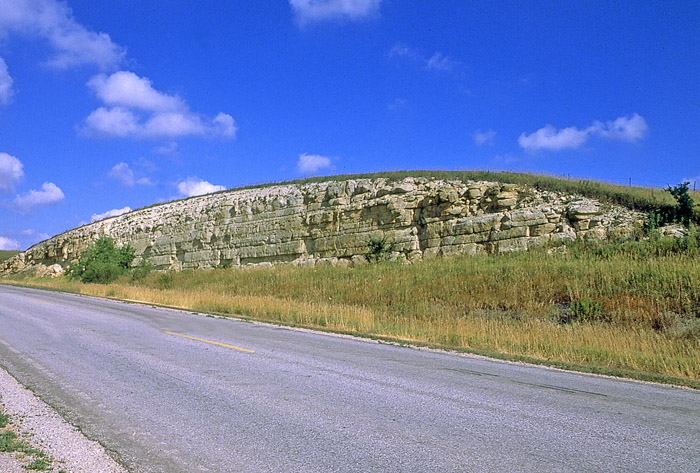
Smoky Hills in Saline County, Kansas by Kathy Alexander.
The Smoky Hills region in north-central Kansas contains the Smoky Hills, an area of rolling hills, occasional mesas, and buttes, with striking outcroppings. It also encompasses a small portion of south-central Nebraska.

Kansas Physiographic Regions by the Kansas Geological Survey.
The area includes a range of hills, mainly composed of sandstone, a second composed primarily of limestone, and a third composed mainly of chalk. Although visibly different, they are unified by age—all were formed from sediment deposited during the Cretaceous Period, which lasted from 145 to 66 million years ago.
During the Cretaceous Period, much of Kansas was under water much of the time. Unlike the relatively shallow seas that covered Kansas in the earlier Carboniferous and Permian periods, the advancing and retreating Cretaceous sea was more profound and more widespread. Three principal rock outcrops characterize the Smoky Hills—the sandstones of the Dakota Formation, the limestones of the Greenhorn Limestone, and the thick chalks of the Niobrara Chalk. Each type of rock formed from sediment that was deposited at different depths or under different environmental conditions.
Niobrara Chalk Formation in Jewell County, Kansas, courtesy of the Kansas Geological Survey.
Over millions of years, rivers and streams flowing through the region carved the rock layers into hills and created wide and flat river valleys. Sediment carried in and deposited by the streams in the river valleys is younger than the rock making up the surrounding hills.
The Dakota Formation forms the eastern region where sandstones crop out in a broad belt from Rice and McPherson Counties in the south to Washington County in the north. They are the remains of beach sands and sediments dumped by rivers draining into the early Cretaceous seas. The hills and buttes in this part of the Smoky Hills, such as Coronado Heights in Saline County, are capped by this sandstone and rise sharply above the surrounding plains. Pawnee Rock, Rock City, and Mushroom Rock State Park are other notable Dakota sandstone formations in this region. Other good examples of Dakota and Kiowa sandstones \of the region can be found at Kanopolis State Park in Ellsworth County and Wilson State Park in Russell and Lincoln Counties. Because of the scarcity of wood, early settlers made stone fence posts from this limestone, a custom that is still in use today. One good place to see limestone construction is the Cathedral of the Plains (St. Fidelis Church) in Victoria, east of Hays, where Inoceramus shell fossils are visible in the walls. This area is called the Smoky Hills, likely due to the early morning haze that often gathers in the valleys, lending its name to the whole region.
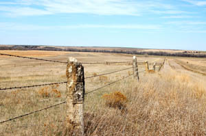
The middle range of hills, to the west of the Smoky Hills range, is topped by the Greenhorn Limestone, formed from sediment deposits in a relatively shallow part of the Cretaceous sea. The chalky limestone beds, which are often less than six inches thick, alternate with beds of blue-gray shale. Near the top of the Greenhorn is a bed called Fencepost limestone. Because timber was scarce in this part of the state, early settlers used limestone extensively for buildings and fence posts. This area is known as post-rock country due to the practice of early settlers using limestone for buildings and fenceposts since trees were scarce.

Monument Rocks in Gove County by Kathy Weiser-Alexander.
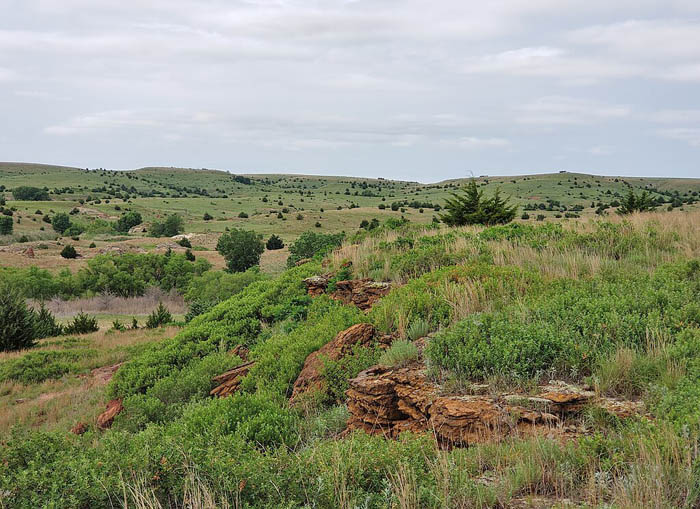
Chalk outcroppings can be seen in the western part of the region. These chalk beds, which formed from massive deposits of shells and skeletons from tiny sea creatures in the deeper part of the Cretaceous sea, have been exposed by erosion in bluffs of the Solomon, Saline, and Smoky Hill Rivers and in an irregular belt from Smith and Jewell Counties to Finney and Logan Counties. Spectacular fossils of large swimming reptiles—plesiosaurs and mosasaurs—and other marine life, as well as gliding pterosaurs, have been chipped out of the chalk beds. Castle Rock and Monument Rocks are large chalk formations found in Gove County. Chalk bluffs are also located in Logan and Trego Counties. These chalk formations, such as Wildcat Canyon in Trego County, are excellent sources of fossils from the Cretaceous Era. The Nature Conservancy’s Little Jerusalem Badlands State Park and Smoky Valley Ranch in Logan County include chalk bluffs and badlands along the Smoky Hill River.
The hills are a dissected plain covered by tallgrass and mixed-grass prairie that hosts a large variety of wildlife species. Coyotes, mule deer, northern myotis bats, the eastern spotted skunk, and some kangaroo rats live in the Smoky Hills. Birds in the region include meadowlarks, prairie chickens, barn owls, burrowing owls, the common nighthawk, dickcissels, lark sparrows, northern bobwhites, red-headed woodpeckers, piping plovers, and Upland Sandpipers. Monarch and Regal Fritillary butterflies are also seen. Reptiles include massasauga snakes, the plains hog-nosed snake, the Texas horned lizard, and the smooth softshell turtle.

Republican River in Cloud County, Kansas by Kathy Alexander.
The aquatic and wooded habitats available near reservoirs and streams showcase a different array of animals. Open water attracts eagles, ospreys, grebes, and sandhill cranes. Woodlands provide hiding places for warblers, beavers, and muskrats. Land use in the Smoky Hills consists primarily of cropland and rangeland. The region is sparsely populated with numerous communities of varying size, but no large cities. The two largest communities in the Smoky Hills region are Salina, Kansas, and Hays, Kansas.
The Republican River, Saline River, Solomon River, and Smoky Hill River all flow eastward through the Smoky Hills from their sources in the High Plains. Beginning in the 1940s, the U.S. Army Corps of Engineers and the U.S. Bureau of Reclamation dammed these rivers at points in the Smoky Hills for flood control and irrigation purposes, creating several reservoirs. These include Cedar Bluff Reservoir, Kanopolis Lake, Kirwin Reservoir, Waconda Lake, Webster Reservoir, and Wilson Lake.
Elevations in the Smoky Hills range from about 1,200 feet in the river valley near Salina to about 2,400 feet at the western edge of the region.
Post Rock Fence in Ellis County, Kansas.
Westward-bound pioneers crossed this area as they traversed the Smoky Hill Trail. The Butterfield Overland Despatch, established at the end of the Civil War, originally carried freight and then passengers from Fort Leavenworth, Kansas, to Denver, Colorado. Today, limestone markers identify two of its crossings along the Smoky Valley Scenic Byway.
Threshing Machine Canyon near Cedar Bluff State Park and Reservoir is the site of an 1867 Native American attack on a Mormon wagon train transporting a threshing machine to Brigham Young in Salt Lake City, Utah. Smoky Hill Trail travelers carved their names in the canyon walls.
Smoky Hills, Kansas, courtesy Wikipedia.
©Kathy Alexander/Legends of Kansas, updated September 2025.
Also See:
Sources:
Historical Marker Database
Kansas Geological Survey
Travel Kansas
Wikipedia