
Arch bridge over the Cottonwood River near Strong City, Kansas, by Kathy Alexander.
Towns & Places:
Cedar Point – Semi-Ghost Town
Cottonwood Falls – County Seat
Elmdale – Semi-Ghost Town
Strong City
One-Room, Country, & Historic Schools of Chase County
Chase Lake Falls
Chase State Fishing Lake
Flint Hills National Scenic Byway
Pioneer Bluffs Ranching Heritage

Chase County, Kansas Location.
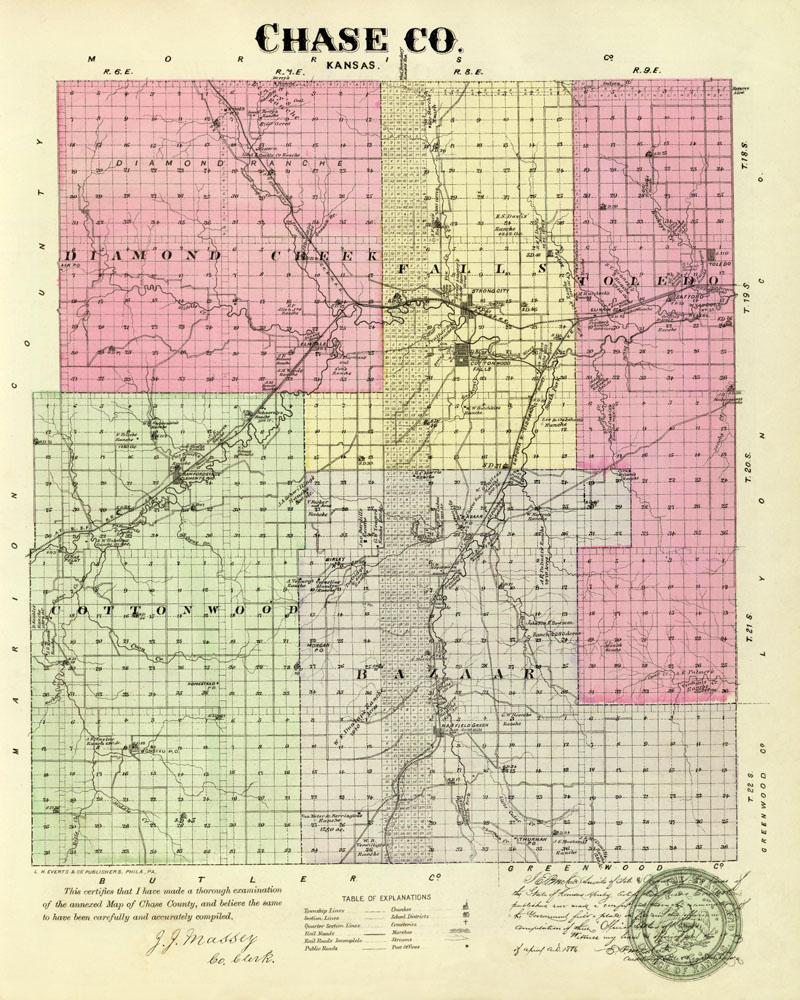
Chase County Map by L.H. Everts & Co., 1887
Chase County, Kansas, is located in the east-central part of the state and was organized in 1859. It was named for Salmon P. Chase, the chief justice of the United States Supreme Court. As of the 2020 census, the county population was 2,572. Cottonwood Falls is the county seat and the most populous city.
It is 50 miles south of the Kansas River and 100 miles west of Missouri. It is bounded on the north by Morris County, on the east by Lyon and Greenwood, on the south by Greenwood and Butler, and on the west by Marion County.
The county’s terrain is somewhat broken and hilly, especially in the southern portion, while in the north, there are gently rolling slopes. In some places along the streams, the slopes terminate in abrupt bluffs. The Cottonwood River is the principal stream and, with its numerous tributaries, forms the county’s water system. It enters the county from the west about 12 miles from the southern line, flows northeast to Cottonwood Falls, and then east into Lyon County. Some significant creeks are Diamond, Fox, and Middle Creeks on the north and Fork and Cedar on the south. When the county was organized, the river bottoms averaged over two miles in width, those on the creeks three-fourths of a mile, and comprised about one-eighth of the total area. The timber belts along the streams averaged less than half a mile in width and contained walnut, cottonwood, burr-oak, sycamore, ash, hickory, hackberry, box-elder, redbud, and buckeye trees. Limestone was of excellent quality, and material for building brick was abundant.

Chase County, Kansas, landscape near Bazaar by Kathy Alexander.
Before European settlement, Native Americans traveling across the Flint Hills established trails throughout Chase County. These trails were easy to navigate and had access to water. One trail along the Cottonwood River became known as the Kaw Indian Hunting Trail. The Kaw, also called Kanza, traveled southwest along the Cottonwood River to reach their hunting grounds in western Kansas. Pioneers later used these same trails between Council Grove and Florence.
In 1806, Zebulon Pike led the Pike Expedition westward from St. Louis, Missouri, following the Cottonwood River through Chase County.

Kanza Men.
The earliest settlement was made in 1854, when Seth Hays, an Indian trader at Council Grove, located a cattle ranch on the Cottonwood River near the mouth of Diamond Spring Creek. Two years later, Nathan Corey, Daniel Holsinger, and Gabriel Jacobs settled in the eastern part of the county. Among those who came in 1857 were Dr. M.R. Leonard, B. McCabe, J. Lane, M. Coyne, A. Howell, C.T. Hegwer, William Osmer, William Dixon, Walter Watson, A.B. Wentworth, Milton Ford, James Fisher, and several families from Illinois.
The first assessment was made in 1859, and the total property valuation was $71,536. Lodges, churches, and societies of different kinds were organized early in the county’s history.
There were 549 people in the county when it was organized by an act of the legislature in 1859. It was formed out of territory taken from Butler and Morris Counties. Initially, three townships were formed—Falls, Bazaar, and Cottonwood—and voting places were designated. The first election was held on March 26 and resulted as follows: M.R. Leonard, probate judge; A.W. Smith, sheriff; Sidney A. Breese, register of deeds; R. C. Farnsworth, superintendent of public instruction; J.F.R. Leonard, surveyor; J.W. Hawkins, coroner; C.S. Hill, clerk of the board of supervisors; Samuel N. Wood, Augustus Howell, and Barnard McCabe, supervisors.
Chase County was located in the Fifth Judicial District, and the court was held in the Congregational church at Cottonwood Falls for some time. The first courthouse was a log building bought in 1863 from George W. Williams for $175.
The first schoolhouse was erected in Bazaar Township in 1860, and the schools before that time had been taught in private homes. The first post office was also located in Bazaar in 1860, with George Leonard as postmaster. The Fratchet grocery store, established in 1859 in Cedar Point, was the first business enterprise in the county.
When the Civil War began in 1861, out of the 262 voters of Chase County, 72 enlisted at once. Samuel N. Wood was made captain of Company I, Second Kansas Infantry. He was made brigadier-general of the state militia in 1864, and several other Chase County men achieved distinction in the war to preserve the Union.

Chase County Courthouse in Cottonwood Falls, Kansas, by Kathy Alexander.
In 1871, $40,000 was voted for public buildings, and two years later, the courthouse in Cottonwood Falls was completed for $42,600. The city donated the square in which it stands. The first county officers served without pay. The Chase County Courthouse, constructed of walnut and limestone quarried on the town site, is the oldest courthouse in Kansas still in use. The courthouse was designed in French Renaissance style by John G. Haskell, the first architect of the statehouse in Topeka. Standing 113 feet tall, you can see the courthouse and its red mansard roof from vantage points throughout the county on most days. This structure features a three-story spiral staircase made from walnut trees from the Cottonwood River. It was listed on the National Register of Historic Places in 1971.
The first railroad was the Atchison, Topeka & Santa Fe Railroad, which extended its main line from Emporia to Newton in 1871. It was at this time that settlement began to boom. The county only had 1,900 people in 1870, but more than 6,000 by 1880.
The first fair was held in October 1881 at Cottonwood Falls and is still on the same site as the original.
In 1887, the Atchison, Topeka & Santa Fe Railroad built a branch line from Neva, three miles west of Strong City, to Superior, Nebraska.
Chase County’s population peaked at 8,246 in 1900.
In 1910, the Atchison, Topeka & Santa Fe Railroad entered the county from the east, about eight miles below the north line, ran west to Strong City and Cottonwood Falls, then southwest through Elmdale and Clements, and on into Marion County. There was also a branch of the same line operating between Strong City and Abilene, which ran northwest from Strong City and left the county near the northwest corner. A few miles south, a branch line connected Cottonwood Falls with Bazaar.

Atchison, Topeka & Santa Fe Railroad Depot at Cottonwood Falls, Kansas.
From the beginning, Chase County was a rich agricultural and stock-raising county. Grazing lands were plentiful, and numerous large ranches were established. The total value of farm products in 1910 was nearly $3,000,000, of which livestock amounted to $1,500,000, and corn, the largest field crop, brought $500,000. At that time, the county population was 7,527. The assessed valuation of the property was over $18,000,000, which made the wealth per capita nearly $2,500.
In the following decades, the population declined as agricultural technology advanced.
Interesting sites in the county include the Chase County Courthouse, the Spring Hill Ranch House on the Z-Bar ranch, the Samuel N. Wood House, the Lower Fox Creek School, the Clements Stone Arch Bridge, the Chase County National Bank Building, the Carter Building, the Clover Cliff Ranch House, the Crocker Ranch Buildings, and the Cottonwood River Bridge in Cottonwood Falls.

Historic stone arch bridge in Clements, Kansas, by Kathy Alexander.
©Kathy Alexander/Legends of Kansas, updated January 2026.
Also See:
Chase County, Kansas Photo Gallery
Sources:
Blackmar, Frank W.; Kansas: A Cyclopedia of State History, Vol I; Standard Publishing Company, Chicago, IL 1912.
Chase County
Cutler, William G.; History of Kansas; A. T. Andreas, Chicago, IL, 1883.
Kansas GenWeb
Kansas Historical Society
Wikipedia