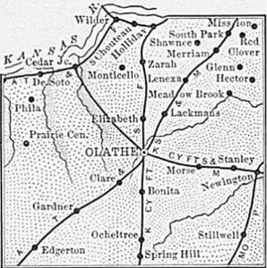
Aubry – Bleeding Kansas Battleground
Chouteau – Long Lost Trading Post
Holliday – Lost Town to Landfill
Lanesfield & the Battle of Bull Creek
Stanley – Absorbed by Overland Park
Sunflower Ordnance Works & Village/Clearview City
More Extinct Towns
|
Town |
Post Office Dates | Additional Information |
| Allendale | 1862-1863 | |
| Bartleson | 1872-1874 | |
| Black Bob | 1875-1879 | Chief Black Bob and his Shawnee band of Cape Girardeau, Missouri, lived on land controlled by Spain in eastern Missouri before moving to Kansas. |
| Cedar Junction | 1877-1919 | Cedar Junction, also called Cedar and Corliss, its railroad name, was located on the south bank of the Kansas River about 19 miles southwest of Kansas City. A post office was located along the Atchison, Topeka & Santa Fe Railroad on January 16, 1877. In 1910, Cedar Junction had a population of 161, a money order post office, general stores, and express and telegraph facilities. It served as the supply and shipping point for the rich agricultural district. Its post office was closed on April 30, 1919. |
| Choteau | None | A little station on the Atchison, Topeka & Santa Fe Railroad 12 miles west of Kansas City, between Holliday and Wilder. It took its name from the Choteau brothers, early pioneers of Johnson County, establishing a trading post here in 1827. |
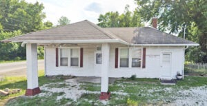
| Clare/Wainwright | 1899-1913 | Located on the Atchison, Topeka & Santa Fe Railroad, five miles southwest of Olathe, this town was first called Wainwright. It received a post office on November 27, 1899. Later the name was changed to Clare by the Kelly family, in honor of Clare County in Ireland. The post office officially changed its name on May 17, 1906. In 1910, Clare had a population of ten, a money order post office and telegraph and express facilities, a grain elevator, a store, and a school. The post office was closed on September 30, 1913. Later the elevator burned down and the store and school were remodeled as residences. |
| Craig | 1899-1902 | Craig was a station on the Atchison, Topeka & Santa Fe Railroad, seven miles north of Olathe. |
| Four Houses | None | Francois Chouteau established a trading post in 1822 on the north bank of the Kansas River, one mile above the mouth of Cedar Creek. The post was called “Four Houses” because it consisted of four log houses arranged in a fort-like square. |
| Glenn | 1868-1895 | Glenn was located on an early course of the Santa Fe Trail in northeast Johnson County. A post office was established on January 21, 1868, and discontinued on April 30, 1895. |
| Haysville | 1858-1860 | |
| Kenneth/Mastin/Newington | 1890-1943 |
This place was first called Newington. The post office’s name changed to Mastin on September 7, 1899. The post office name changed from Mastin to Kenneth on April 29, 1907. In 1910, it was located on the Missouri Pacific Railroad and had a money order post office, telegraph, and express facilities and a population of 30. The Kenneth post office closed on April 14, 1943. Today, Kenneth is part of Overland Park, Kansas. It was located at W. 151st and Kenneth Road, about three miles east of Stanley. In 1915, Clyde Clark had a general store here. It was situated almost on the Missouri line, a |
| Jerusalem | 1895-1900 | Located two miles northeast of Gardner, Kansas, Jerusalem once had a store, blacksmith shop, school, and several residences. A post office was established on April 11, 1895, and discontinued on December 31, 1900. |
| Lackman | None | A station on the Frisco Railroad, Lackman was three miles north of Olathe. It was established in 1857, and before it was completely gone, it had a whiskey shop and two claim shanties. |
| Lexington | 1857-1863 | This small town located three miles south of DeSoto was laid out in 1857 by pro-slavery settlers. A post office was established on June 29, 1857. De Soto was established as a Free State town the same year, and there was an immediate rivalry. A two-story hotel was built in 1860, and a general store sold whiskey to the Indians. Kansas was admitted to the Union as a Free State in January 1861, and Lexington soon went downhill. The post office was closed on January 14, 1863, and by the next year, the town was vacated due to the building of the Sunflower Ordinance Plant. |
| Meadow Brook | 1875-1881 1882-1885 1887-1896 |
|
| Phila | 1890-1894 1898-1899 |
This small town was located near DeSoto and Lexington in the northwestern part of the county. A post office was established on May 29, 1890, and discontinued on October 31, 1894. It was re-established on May 27, 1898, and finally abandoned on May 15, 1899. |
| Pioneer | 1897-1900 | Pioneer was located on one of the creek tributaries of the Kansas River, about seven miles northwest of Olathe. A post office was established on November 2, 1897, and discontinued on November 15, 1900. The grange located here is probably the oldest in the country. |
| Princeton | None | In 1857, the Princeton Town Company, of which Albert White, D.H. Mitchell, T.E. Milhoan, and George String Ham were members, laid out the town of Princeton, comprising 160 acres, and began to sell town lots. Soon, two stores, a blacksmith shop and a shoe shop, were located there. Princeton was a Free State town, and its people hoped to make it the future county seat. However, when the question came up to a vote, the Shawnee Indians were declared legal voters for this occasion, and their votes were almost solid for Olathe. After the Olathe victory, Albert White filed on the old townsite of Princeton. It was about two miles southwest of Olathe. |
| Red Clover | 1881-1887 1891-1895 |
Red Clover was located on the county line outside Kansas City, Kansas. |
| Romance | 1876-1877 1878-1879 |
|
| Sherman | 1865-1869 | The post office moved to Lenexa on July 15, 1869. |
| South Park | 1888-1894 | |
| Squiresville | 1857-1868 | |
| Switzer | None | A station on the Frisco Railroad 12 miles north of Olathe. Large quantities of milk were shipped from this place to Kansas City, Missouri. |
| Zara | 1882-1887 | |
| Zarah | 1890-1954 | Zarah was a village in the northern part of Johnson County. It was located on the Atchison, Topeka & Santa Fe Railroad and an electric line. It was located ten miles north of Olathe. In 1910, it had a money order post office, telegraph and express facilities, and a population of 50. In 1915, Harry King had a general store there and did extensive business. It was located at 69th and Martindale in present-day Shawnee, Kansas. |
©Kathy Alexander/Legends of Kansas, updated January 2025.
Also See:
Sources:
Blackmar, Frank W.; Kansas: A Cyclopedia of State History, Vol I; Standard Publishing Company, Chicago, IL, 1912.
Blair, Ed; History of Johnson County, Stand Publishing Company, Lawrence, KS, 1915.
Cutler, William G; History of Kansas; A. T. Andreas, Chicago, IL, 1883.
Johnson County History
Steed, Laura; Ghost Towns of Johnson County, 1973, unknown publisher.


