
The Cathedral of the Immaculate Conception, St. Mary’s, Kansas, was the first Catholic cathedral built West of the Missouri River.
A B C D E F G H I J K L M N O P Q R S T U V W X Y Z
S
| Place Name | County | Place Type | Post Office Dates | More Information |
| Sabetha | Nemaha | Current Town | Located on St. Joseph and California Road; post office 1858, Arthur W. Williams, postmaster. | |
| Sabra | Saline | Lost Town | 1867-1870 | |
| Sac & Fox Agency | Franklin | Lost Town | Post office in 1855. | |
| Sac Branch | Franklin | Lost Town | 1861-1863 | Sac Branch |
| Saffordville/Kenyon/ Safford |
Chase | Lost Town | 1872-1957 | It was located on the Atchison, Topeka & Santa Fe Railroad in Toledo Township. |
| St. Benedict | Doniphan | Lost Town | 1870 | The post office was open for just less than a year |
| St. Benedict | Nemaha | Extinct Town | 1883-1902 | The beautiful St. Mary’s Church was built in 1893. The church continues to provide services today, and several homes remain in the area. |
| St. Bernard | Franklin | Lost Town | Incorporated 1857. | |
| St. Bridget | Marshall | Extinct Town | 1869-1906 | The post office moved from Fairland. It was located about 6.5 miles North of Axtell. A historic church still stands. |
| St. Clere | Pottawatomie | Extinct Town | 1874-1953 | Saint Clere is an extinct town on Cross Creek in St. Clere Township of Pottawatomie County, Kansas. It was almost on the county’s East line, 22 miles East of Westmoreland, the county seat, and 13 miles North of St. Marys. |
| St. Cloud-Solomon | Dickinson | Name Change | Now Solomon. | |
| Saint Francis | Brown | Lost Town | 1871-1872 | The post office moved from Buncomb. |
| St. Francis | Cheyenne | Current Town | County seat. Founded in 1887 and named to honor one of its founding citizens, Francis Emerson. | |
| St. George | Pottawatomie | Current Town | It was on the Kansas Pacific Railroad. | |
| St. John | Allen | Lost Town | Incorporated in 1860. | |
| St. John | Decatur | Lost Town | Founded in 1879, named for Governor J.P. St. John; name changed to Hooker. | |
| St. John | Stafford | Current Town | County seat. Founded in the mid-1870s. It was on the Atchison, Topeka & Santa Fe Railroad. | |
| St. John Center | Logan | Lost Town | None | St. John Center was established in 1885. |
| St. Joseph | Cloud | Extinct Town | 1878-1882 1885-1901 |
St. Joseph was founded in 1873 by its first Catholic pastor, Father Louis-Marie Mollier. It’s beautiful. St. Joseph Catholic Church rises above the prairie. |
| Ost-St. Joseph | Reno | Extinct Town | 1882-1911 | A country office and trading center for Sumner Township. It still has an active church and school. |
| St. Joseph & Elwood Ferry | Doniphan | Lost Place | Operated 1855-72. Robert Jessee & Ebenezer Blackiston, proprietors. Steam ferry, Tidy Adala, later replaced by Ebenezer. | |
| St. Julian | Clay | Lost Town | On the Republican River. | |
| St. Leander | Johnson | Lost Town | Incorporated in 1855, at the confluence of the Kansas and Missouri Rivers. | |
| Saint Leo | Kingman | Lost Town | 1904-1905 | |
| St. Louis/Louisburg | Miami | Name Change | Now Louisburg. | |
| Saint Mark | Sedgwick | Extinct Town | 1879-1903 | It was located on the line between Union and Attica Townships amid a German settlement. |
| St. Mary’s Mission | Linn | Lost Town | ||
| St. Mary’s/St. Mary’s Mission | Pottawatomie | Current Town | Originally a Jesuit Mission to the Potawatomi Indians. Founded in 1848. It was a trade and rest stop on the Oregon Trail. On the Kansas Pacific Railroad. The name changed to St. Mary’s in 1878. | |
| St. Marysville | Miami | Name Change | Changed to Lyon, 1866. | |
| St. Nicholas | Atchison | Lost Town | 1859-1863 1868-1873 |
The post office moved to Cummingsville in December 1873. |
| St. Paul | Chautauqua | |||
| St. Paul | Montgomery | Lost Town | ||
| St. Paul/Osage Mission | Neosho | Current Town | Originally called Osage Mission, it was founded by Jesuit Missionaries in 1847 to bring education to the Osage Indians. It was once the county seat of Neosho County. The name changed to St. Paul. It was on the Missouri, Kansas & Texas Railway. | |
| Saint Paul | Sheridan | Lost Town | 1879 1882 |
|
| St. Petersburg | ||||
| Saint Sophia | Ness | Lost Town | 1879-1883 | The post office moved to Utica after it closed. |
| Saint Theresa | Wichita | Lost Town | 1886-1904 1908-1916 |
St. Theresa was established in 1886 and was named for Mrs. Theresa Scheve, one of the early-day settlers. A Catholic Church was built there in 1887. Described as a close-knit community or neighborhood, it had its nearest shipping point in Leoti, 12 miles to the northwest. The population in 1910 was 20. All that is left today is a cemetery. |
| Salamanca | Cherokee | Lost Town | ||
| Salem | Douglas | Lost Town | On the Santa Fe Trail. See Louisiana | |
| Salem | Jewell | Lost Town | 1871-1903 | Salem, situated ten miles East of Burr Oak in the fertile White Rock Valley, was an inland town in White Mound Township. In 1910, its population had dropped to 51. Its only remaining feature today is the cemetery. |
| Salemsburg | Saline | Lost Town | 1875-1902 | Also spelled Salemsburgh. This was an inland hamlet in Smoky View Township. |
| Salina | Saline | Current Town. | County seat. On the Smoky Hill Trail and the Kansas Pacific Railroad. | |
| Saline County | Saline | Current County | NA | Created from an unorganized area in 1860. Salina is the county seat. |
| Sallee/Salee/Norwalk | Kingman | Lost Town | 1879-1888 | This place was first called Norwalk when the post office opened on January 28, 1879. The town’s name changed to Salee on June 14, 1883. The spelling of the town’s name changed from Salee to Sallee on July 3, 1883. |
| Sallyards | Greenwood | Lost Town | 1918-1943 | Named for S. G. Sallyards, a rancher. |
| Salsbury | Bourbon | Lost Town | ||
| Salisbury | Cherokee | Lost Town | 1859-1860 | |
| Salt City-Remanto | Sumner | Lost Town | 1872-1885 | The name changed from Remanto to Salt City on October 26, 1874. It was immediately North of Geuda Springs at 120th Street South and the Cowley Line. |
| Salt Creek/Wilson’s Trading Post. | Leavenworth | Lost Town | 1863-1864 | The post office was called Salt Creek. |
| Salt Creek | Reno | Lost Town | 1873-1886 | The post office moved to Abbyville. |
| Salt Creek Bridge | Leavenworth | Lost Place | NA | Salt Creek Bridge was established in 1844 in Kickapoo Township. Robert Wilson established a trading post in 1854. Located on the Fort Leavenworth-Fort Riley Military Road. Near County Road 14. |
| Salt Marsh | Republic | Lost Town | See Seapo. | |
| Salt Marsh | Washington | Lost Town | ||
| Salt Springs | Greenwood | Lost Town | 1867-1873 | |
| Salt Springs | Saline | Lost Town | ||
| Salt Springs | Sumner | Lost Town | None | It was established in approximately 1878 and located five miles south of Oxford, at the intersection of 60th Street South and Oxford Road. |
| Saltville | Mitchell | Lost Town | 1873-1901 | Saltville was an inland hamlet in Salt Creek Township of Mitchell County. Saltville was located on Salt Creek in the southeastern part of the county. It was about 12 miles south of Beloit, the county seat, and seven miles northwest of Barnard, from which place it received its mail by rural route after its post office closed. The population in 1910 was 25. |
| Samaria | Montgomery | Paper Town | A paper town near Walker Mound. | |
| Sampson | Marion | Lost Town | 1881-1883 | |
| Sand Spring | Dickinson | Lost Town | ||
| Sanford | Pawnee | Named for Sanford Arnold, pioneer and townsite owner. | ||
| Sanford | Phillips | Lost Town | 1903 | Albert Boland, located in Dayton Township, served as the first postmaster. The post office was only open for about six months. |
| Sanford | Sedgwick | Lost Town | ||
| Sandfordville | Cherokee | Lost Town | 1870-1871 | See Coalfield. |
| Sandusky | Shawnee | Lost Town | 1890-1895 | |
| Santa Fe | Haskell | Lost Town | 1886-1925 | Santa Fe, Kansas, an extinct town in Haskell County, was the county seat for 26 years. The town is gone today; only the cemetery remains. |
| Santa Fe Road Ferry | Wyandotte | Lost Place | Established in 1857 on the Kansas River in Kansas City. | |
| Sapling Grove | Johnson | Lost Place | NA | This campground was established in 1834 on the Santa Fe Trail. It is a park in Overland Park, Kansas, today. |
| Sappa City-Oberlin | Decatur | Lost Town | Now Oberlin. | |
| Sappa Creek | Multiple | Current Creek | NA | Sappa Creek is a stream in the central Great Plains of North America. A tributary of the Republican River, it flows generally eastward for 150 miles through Kansas and Nebraska. |
| Sarah | Gove | Lost Town | 1881-1884 | A country post office in the northeast of Gove County, it was on the stagecoach route from Buffalo Park to Ness City, from which the mail was delivered semi-weekly to S. C. Walters, the postmaster. It was seven miles south of Buffalo Park, the nearest railroad point. |
| Saratoga | Pratt | Lost Town | 1878-1895 | It was located three miles East of Pratt |
| Sarcoxie | Jefferson | Lost Town | 1889-1901 | Located in Sarcoxie Township, the historic Sarcoxie Cemetery remains standing. |
| Sargent | Hamilton | Name Change | The name changed to Coolidge. It was on the Atchison, Topeka & Santa Fe Railroad. | |
| Satanta | Haskell | Current Town | On the Cimarron Branch of the Santa Fe Trail. | |
| Sauce | Ness | Lost Town | 1881-1883 | |
| Saunders | Ness | Lost Town | 1886-1895 | |
| Saunders | Rush | Lost Town | 1895-1908 | Located 10 miles northwest of La Crosse and eight miles West of Liebenthal. |
| Saunders’ Ferry | Jefferson | Lost Place | Established in 1869 on the Kansas River, 1/2 mile southwest of Medina. Wales Saunders was the proprietor. | |
| Sautrell Falls | Jefferson | Name Change | Established as Grasshopper Falls in 1855, now Valley Falls. | |
| Savannah | Pottawatomie | Lost Town | 1867-1868 | Savannah was established on the Red Vermillion River in the northeastern part of Pottawatomie County. The post office was only open for about six months. |
| Savannah Landing | Leavenworth | Lost Place | On the Missouri River near Amazonia, Missouri. Known initially as Owens’ Landing in 1842, it was later renamed Caples’ Landing in 1846. | |
| Saviersville | Wyandotte | Lost Town | 1867-1868 | The post office was open for less than a year. |
| Savonburg | Allen | Extinct Town | 1879-1998 | This small town is still home to numerous homes, several historic business buildings, an active church, and a population of 74. |
| Saw Qaw (Osawkie?) | Jefferson | Lost Town | ||
| Sawe Place or Suie Place | Wilson | |||
| Sawlog | Hodgeman | Lost Town | 1883-1884 | Edward Waters, postmaster. |
| Sawlog Creek Crossing | Ford | Lost Place | Located on the Fort Hays-Fort Dodge Military Road, the crossing of Sawlog Creek was in northern Ford County. | |
| Saw-Qua | Shawnee | Lost Town | 1871-1873 | Also known as Saw-Gua. |
| Sawyer | Pratt | Current Town | On the Atchison, Topeka & Santa Fe Railroad. | |
| Saxman | Rice | |||
| Sayre | Ford | Named for Kaye Sayre, a pioneer. | ||
| Scammon/Scammonville | Cherokee | Current Town | A small coal-mining town located just a mile North of Stilson. Now Scammon. Named for four Scammon brothers from Illinois. | |
| Scandia | Republic | Current Town | Settlement of Swedes promoted by the Scandinavian Agricultural Society of Chicago. | |
| Scheuerman | Rush | Lost Town | 1883-1888 | |
| Schley | McPherson | Lost Town | 1898-1902 | |
| Schockley, Shockley | Mitchell | Lost Town | ||
| Schoenchen | Ellis | |||
| Schoharie | Ness | Lost Town | ||
| Schroyer | Marshall | Lost Town | 1889-1918 | Named for Peter Schroyer, town promoter. Nothing remains. |
| Schulte | Sedgwick | Lost Town | 1906-1934 | Located in Waco township on the Kansas City, Mexico & Orient Railroad, 12 miles southwest of Wichita. In 1910, it had a general store, livery barn, telegraph and express offices, and a population of 70. |
| Scipio | Anderson | Extinct Town | 1859-1905 | Scipio is an extinct town in Putnam Township in Anderson County, Kansas. However, it is still home to the beautiful St. Boniface Catholic Church. |
| Schoenchen | Ellis | Current Town | ||
| Scoharie | Lost Town | 1872-1889 | ||
| Scotch Plain | Republic | Lost Town | 1871-1874 | A short-lived community in Scandia Township, in the southwestern corner of Republic County. |
| Scott City-Scott | Scott | Current Town | 1880 1885-Present |
Scott City, Kansas, is a city and the county seat of Scott County. As of the 2020 census, the city’s population was 4,113, and it had a total area of 2.63 square miles, all land. It is located in the Great Plains at an elevation of 2979 feet.
|
| Scott County | Scott | Current County | NA | Created from an unorganized area in 1873. The county seat is Scott City. |
| Scott Land | Jefferson | Lost Town | 1865-1871 | |
| Scottstown | Coffey | Lost Town | Near Le Roy. | |
| Scottsville-Lulu | Mitchell | Current Town | 1873-1967 | When this place got its start, it was first called Lulu. It was located in Lulu Township in the extreme northeastern corner of the county. A post office was established on December 24, 1873. Its name changed to Scottsville on November 12, 1878. There are still homes and buildings in the area. |
| Scranton | Osage | Current Town | On the Santa Fe Trail. | |
| Seabrook | Shawnee | Lost Town | 1887-1899 | |
| Seabury | Ness | Lost Town | 1880-1884 | |
| Seaman | Linn | Lost Town | 1883-1889 1890-1903 |
|
| Seapo-Salt Marsh | Republic | Lost Town | 1866-1889 | Seapo was a rural community located in Grant Township, Republic County. It was first established as Salt Marsh in 1866. It had a grist mill, three churches, and a school. |
| Sears | Ford | Lost Town | None | Sears never had more than a telegraph station and a rural schoolhouse. |
| Seaver, Highland Station, Sparks | Doniphan | Name Change | The name changed to Highland Station. In 1908, the city changed its name to Sparks. | |
| Sebastian | Wyandotte | Lost Town | Incorporated in 1857. | |
| Secondine/Delaware | Wyandotte | Lost Town | 1850-1859 | The name changed from Delaware to Secondline on February 1, 1856. It was near Edwardsville. |
| Section | Coffey | Lost Town | 1882-1894 | |
| Sedan | Chautauqua | Current Town | 1871-1873 1874-Present |
Sedan is the county seat and the largest city in Chautauqua County, Kansas. As of the 2020 census, the city had a population of 1,000 and a total land area of 0.81 square miles. It is located near the county’s geographical center in Sedan Township, along the Middle Caney River. |
| Sedan | Phillips | Lost Town | ||
| Sedgwick | Harvey | Current Town | ||
| Sedgwick County | Sedgwick | Current County | Formed from Butler County in 1867. The county seat is Wichita. | |
| Sedowa | Sedgwick | Lost Town | 1886-1903 | |
| Sego | Reno | Lost Town | 1874-1905 | Sego had a school, a church, a general store, a constable, and a creamery. Its population was 16 in 1910. It was located 18 miles southwest of Hutchinson. |
| Seguin-Gerona | Sheridan | Lost Town | 1889-1943 | The town of Seguin, in Logan Township, started as a work camp named Gerona in 1887. The Union Pacific Railroad constructed it on the Salina-Oakley branch line, and a depot was built in 1888. |
| Seigel | Lost Town | 1900-1901 | ||
| Selden | Sheridan | Current Town | ||
| Selkirk | Wichita | Extinct Town | 1887-1906 1907-1908 1909-1980 |
Located between Leoti and Tribune, Kansas, Selkirk is an unincorporated community in Wichita County and an extinct town, as it no longer has a post office. |
| Selma | Anderson | Lost Town | 1887-1956 | The town was at the junction of the Kansas, Nebraska, and Dakota Railroad and the Missouri, Kansas & Texas Railway. |
| Seneca | Nemaha | Current Town | 1858-Present | County seat. Established in 1857. Located on the Fort Leavenworth-Fort Laramie Military Road at the crossing of the South Fork of the Nemaha River. On the Oregon Trail. Home station for the Overland Stage and Pony Express. |
| Seth | Norton | Lost Town | None | The Chicago, Burlington & Quincy Railroad was built through this area in 1885. David F. McFarland and Ida H. McFarland owned the land. Seth was first platted in 1887. It was located south of the railroad tracks on Highway 383. There was a railway depot and stockyards on the siding. A few area residents went together to establish businesses. |
| Seven Springs-Mair’s Spring | Geary | Lost Place | A campground was established in 1857 at Kansas Falls on the Smoky Hills Trail six miles West of Junction City. | |
| Severance | Doniphan | Current Town | Named for John Severance, town promoter. | |
| Severin | Ellis | Lost Town | None | Located five miles northwest of Catherine, the town was founded by former members of the Catharine parish. |
| Severy | Greenwood | Current Town | It was on the St. Louis and San Francisco Railroad and the Atchison, Topeka & Santa Fe Railroad. | |
| Sewanoe | Franklin | Name Change | Now Lane. | |
| Seward | Stafford | Current Town | -1995 | The post office closed on December 9, 1995. |
| Seward County | Seward | Current County | NA | Created from an unorganized area in 1873. The county seat is Liberal. |
| Sexton | Barber | Lost Town | 1884-1899 | |
| Sexton | Wilson | Lost Town | 1900 | The post office’s order of change was rescinded after five months. |
| Seymour | Franklin | Lost Town | ||
| Seymour | Rush | Lost Town | 1880-1881 | |
| Shady Bend | Lincoln | Lost Town | 1880-1963 | |
| Shadybrook | Dickinson | Lost Town | 1901-1907 | |
| Shaffer | Rush | Lost Town | 1892-1948 | Located in Garfield Township on the Atchison, Topeka & Santa Fe Railroad. |
| Shallow Water | Scott | Extinct Town | 1913-1957 | Shallow Water is a census-designated place in Scott County, Kansas. As of the 2020 census, the population was 89. Shallow Water was founded in the early 1900s by Quakers who wanted to provide an institute where their children could learn in a religious setting. This small town still features grain elevators, numerous silos, a church, and a scattering of homes. |
| Shamrock | Seward | On the Chicago and Rock Island Railroad in 1888. | ||
| Shannon/Cedar Bluff | Anderson | Lost Town | 1857-1860 | Located in 1857; abandoned in 1859; county seat until 1859; named in honor of Governor Wilson Shannon. |
| Shannon | Atchison | Lost Town | 1882-1941 | A small village on the Missouri Pacific Railroad about nine miles West of Atchison on the Parallel Road. |
| Shannon | Pottawatomie | Lost Town | Discontinued in 1858; located between the Black Vermillion River and the old town of Pawnee. | |
| Shannon | Riley | Lost Town | 1855-1858 | |
| Sharp’s Creek | McPherson | Lost Town | ||
| Sharlow | Bourbon | Lost Town | 1868-1872 | It was ten miles northeast of Fort Scott. The first postmaster was T.L. Wilson. |
| Sharon | Barber | Current Town | ||
| Sharon | Crawford | Lost Town | ||
| Sharon Springs | Wallace | Current Town | County seat. On the Smoky Hill Trail and the Kansas Pacific Railroad. | |
| Sharpe | Coffey | Lost Town | 1890-1918 | A station on the Atchison, Topeka & Santa Fe Railroad, it had a money order post office, an express office, and a population of 40 in 1910. It was located nine miles North of Burlington. |
| Sharpscreek-Sharp’s Creek | McPherson | Lost Town | 1872-1899 | The name changed from Sharp’s Creek to Sharpscreek on October 15, 1894. |
| Shaw | Neosho | Extinct Town | 1885-1954 |
 Railroad Depot in Shaw Shaw was located in Erie township on the Atchison, Topeka & Santa Fe Railroad. In 1910, it had telegraph and express offices, a thriving local trade, and a money order post office with one rural route, serving a population of 125. There are still a few buildings in the area, and the Shaw Cemetery. It was four miles West of Erie. |
| Shawnee-Gum Spring | Johnson | Current Town | An Indian village on the Santa Fe Trail was formerly known as Gum Spring. | |
| Shawnee County | Shawnee | Current County | NA | Topeka, established in 1855, was one of the original 36 counties created in that year. The county seat is Topeka. |
| Shawnee Mission | Johnson | Historic Site | Old Indian mission and school. Historic site in Fairway, Kansas. | |
| Sheffield | Decatur | Lost Town | 1881 1882-1887 |
Sheffield was located in Sappa Township. After its post office closed, the mail was sent to Enne in Rawlins County. |
| Sheldon | Harvey | Lost Town | 1871-1885 | |
| Shell Rock | Greenwood | Lost Town | 1873-1883 | |
| Shell Rock Falls | Greenwood | Lost Town | 1860-1865 | Established in Madison County. |
| Shenandoah | Lyon or Greenwood | Lost Town | Incorporated 1855; second incorporation 1857. | |
| Sherdahl | Republic | Lost Town | 1887-1905 | A village in Union Township; its population in 1910 was 24. It was located 11 miles northwest of Belleville and about five miles North of Scandia. |
| Sheridan | Greenwood | Lost Town | 1867-1869 | |
| Sheridan | Logan | Lost Town | ||
| Sheridan | Lyon | Lost Town | ||
| Sheridan | Rooks | Lost Town | ||
| Sheridan | Sheridan | Lost Town | 1876-1888 | Sheridan, in Sheridan Township, the county’s oldest town, was established in 1876 by George Kious and Mr. Bayliss. A post office was located one mile West, and Mr. Bayliss was the postmaster. Sheridan’s post office closed on November 10, 1888. At that time, any remaining buildings were moved to Selden. |
| Sheridan County | Sheridan | Current County | NA | Created from an unorganized area in 1873. Hoxie is the county seat. |
| Sherlock/Holcomb | Finney | Current Town | 1878-1880 1883-1890 1909-Present |
It was on the Atchison, Topeka & Santa Fe Railroad. The name changed to Holcomb. Named for D.C. Holcomb, a pioneer. |
| Sherman | Johnson | Lost Town | 1865-1869 | The post office moved to Lenexa on July 15, 1869. |
| Sherman/Kingman | Kingman | Name Change | Now Kingman. | |
| Sherman Center | Cherokee | |||
| Sherman Center-Shermanville | Sherman | Lost Town | 1883-1893 | Sherman Center, originally called Shermanville, near the geographic center of Sherman County, gained a post office on February 15, 1883. On September 20, 1886, the town was officially established by proclamation of Governor John A. Martin, who also designated Eustis as the temporary county seat. Shortly after Goodland was founded several miles to the south, the town of Sherman Center ceased to exist. The post office closed on September 30, 1893. |
| Sherman City | Cherokee | |||
| Sherman City | Labette | Lost Town | ||
| Sherman County | Sherman | Current County | NA | Created from an unorganized area in 1873. Goodland is the county seat. |
| Sherman’s, Shermansville, Dutch Henry’s Crossing | Franklin | Lost Town | 1855-1863 | The name changed to Lane in 1863. |
| Sheron | Allen | Lost Town | 1873-1877 | |
| Shibboleth | Decatur | Lost Town | 1875-1904 | Shibboleth was in Prairie Dog Township. When its post office was discontinued, mail was sent to Dresden. |
| Shibley’s Ford | Marshall | Lost Place | NA | Established on the Big Blue River in Marysville in 1856. Robert Shibley, Proprietor. Near Pony Express Hwy (US 36 | US 77) |
| Shields | Jefferson | Lost Town | 1855-1868 | |
| Shields | Lane | Extinct Town | 1994 | Named for a pioneer. The post office closed on November 12, 1994. |
| Schilling Air Force Base | Saline | Former Fort | NA | Schilling Air Force Base was a former defense site in Salina, Kansas. The base was initially built on 2,600 acres southwest of Salina. It was initially used during World War II as a processing and staging area for heavy bombardment units going overseas. Construction began in May of 1942 with the aid of nearly 7,000 construction workers. It was initially called the Smoky Hill Army Airfield. Today, it is the Salina Airport.
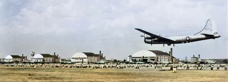 Smoky Hill Army Air Base hangars, with a B-29 preparing to land, circa 1943. |
| Shiloh | Hamilton | Lost Town | 1888-1894 | |
| Shiloh | Ness | Lost Town | Established in 1879. | |
| Sherwin | Cherokee | Named after the landowner. | ||
| Sherwood Estates | ||||
| Shinn | Graham | Lost Town | Discontinued in 1882. | |
| Shipp’s Ferry | Marshall | Lost Place | Established in 1859 on the Big Blue River south of future Irving. James W. & William E. Shipp, proprietors. | |
| Shipton/York | Saline | Lost Town | 1888-1895 | The name changed from York to Shipton on March 29, 1890. It was located northwest of Salina, about 0.75 miles West of the intersection of Halstead Road and Shipton Road, next to an abandoned railroad. |
| Shiretown | Osage | Lost Town | ||
| Shirley | Cloud | Lost Town | ||
| Shockey/Laport | Grant | Lost Town | 1886-1906 | Name change from Laport in 1887. |
| Shockeyville | ||||
| Shockley | Mitchell | Lost Town | 1873-1879 | |
| Shoo Fly | Sumner | Lost Town | ||
| Shorey | Shawnee | Extinct Town | 1889-1907 | A suburb of Topeka, connected to it by an electric line. It was located on the Chicago and Rock Island Railroad and the Union Pacific Railroad. In 1910, it had schools, churches, general stores, nurseries, and a population of 400 |
| Short Creek | Cherokee | Name Change | Now Galena. See also Empire City and Bonanza. | |
| Shreader | Trego | Lost Town | 1878-1881 | |
| Shunganunga Creek | Shawnee | Waterway | NA | |
| Sibley | Cloud | Lost Town | 1868-1876 | Sibley was founded in 1869 and named for Lake Sibley. |
| Sibleyville | Douglas | An Atchison, Topeka & Santa Fe Railroad stop in Wakarusa Township. Known as Sibley by the railroad. | ||
| Sidlow | Ford | Lost Town | 1885-1886 | |
| Sidney | Coffey | Name Change | Now Strawn. | |
| Sidney | Greeley | Lost Town | 1907-1922 | A country post office in Colony Township was located 15 miles northwest of Tribune. |
| Sidney | Ness | Lost Town | 1877-1888 | Sidney was laid out North of the junction of the South Fork with the main Walnut Creek on June 6, 1879. The Sidney Town Company was organized in July 1879; E.M. Bill was President; R.B. Linville, Vice President; H.S. Bell, Secretary; and A.F. Gardner, Treasurer. In April 1880, it was made the temporary county seat. |
| Sigel | Douglas | Lost Town | 1862-1895 | |
| Siggins | Sherman | Lost Town | 1886-1888 | |
| Silica | Phillips | Lost Town | 1887-1890 | Silica was located in Plainview Township. The first postmaster was Adam C. Shoemaker, who operated a grist mill on Bow Creek. |
| Silkville | Franklin | Lost Town | Formerly Valeton. | |
| Silver Creek | Chase | Lost Town | 1861-1881 | The post office moved to Crawfordsville. |
| Silver Lake | Shawnee | Current Town | On the Oregon Trail and the Kansas Pacific Railroad. | |
| Silver Spring | Nemaha | Lost Town | 1872-1875 | |
| Silverdale | Cowley | |||
| Silverton | Stafford | Lost Town | ||
| Simmons’ Ferry | Douglas | Lost Place | NA | Established in 1852 on the Kansas River at Bald Eagle, opposite Lecompton. William K. Simmons, Proprietor. Near Eisenhower Memorial Dr. and E 600th Rd. |
| Simpson-Brittsville | Mitchell | Current Town | 1874-Present | Simpson is a small town in both Mitchell and Cloud Counties. As of the 2020 census, its population was 82, and it had a total area of 0.25 square miles, all of it land. This place was named for Alfred Simpson, a grain dealer. |
| Sing Sing | Sumner | Lost Town | ||
| Sitka | Clark | |||
| Six-Mile | Wyandotte | Lost Town | 1874-1878 | Six-Mile Tavern was established just a few miles West of Quindaro, Kansas, on the road between Wyandotte (Kansas City) and Leavenworth in 1853. It became a Red Leg stronghold during the Civil War. |
| Six Mile Creek | Morris | Lost Town | 1863-1866 | Crossing of the Santa Fe Trail, ranch, post office, stage station. |
| Skellyville | Kingman | When oil was discovered on “Poverty Ridge” in Kingman County, the place was named Skellyville. | ||
| Skiddy | Morris | Ghost Town | 1869-1953 | Located on the Morris/Geary county line, this town was established in 1870 by a mixed colony from Pennsylvania and New Jersey. Named for Francis Skiddy of New York, a magnate of the old Union Pacific Railroad. It was also on the Missouri, Kansas & Texas Railway. |
| Skidmore | Cherokee | Lost Town | 1903-1915 | The Skidmore mining camp was an unincorporated community located seven miles North of Columbus. |
| Slab City | Decatur | Lost Town | ||
| Slade | Reno | Lost Town | On the Chicago and Rock Island Railroad in 1887. | |
| Slate | Rooks | Lost Town | 1880-1903 | A hamlet on Slate Creek, 16 miles northwest of Stockton, the county seat, and 12 miles south of Logan, in Phillips County, from which place it received its mail after its post office closed. The population in 1910 was 36. |
| Slate Creek | Sumner | Lost Town | 1877-1878 | |
| Smallwood-Smallwood City | Ness | Lost Town | Named for W.H. Smallwood, secretary of state. | |
| Smalley | Pratt | Also spelled Smally. On the Chicago and Rock Island Railroad in 1887. | ||
| Smallwood | Comanche | |||
| Smileyberg | Butler | Ghost Town | None | Some structures remain, and a transmission shop is open. |
| Smith Center | Smith | Current Town | County Seat. Founded by L. T. Ruse, his farm was the first county seat. | |
| Smith County | Smith | Current County | NA | Created from an unorganized area in 1867. Smith Center is the county seat. |
| Smithfield | Butler | Lost Town | See Lorena. | |
| Smithfield | Doniphan | Lost Town | ||
| Smithland | Jackson | Lost Town | ||
| Smith’s Ferry | Shawnee | Lost Place | NA | Established in 1852 on the Kansas River near Topeka. Sidney W. Smith, proprietor. |
| Smith’s Station | Nemaha | Lost Place | NA | Established in 1856, Charles Smith, Proprietor. On Lane’s Trail at the crossing of Gregg’s Creek, about four miles northeast of Wetmore. It was a station on the Underground Railroad. |
| Smithton-LaPorte | Doniphan | Lost Town | 1855-1858 | Name changed to La Porte; vacated 1864. The name changed to LaPorte in 1858. |
| Smithton | Norton | Lost Town | 1884-1886 | |
| Smithville | Clay | Lost Town | 1873-1874 | The post office was only open for about five months. |
| Smithville | Smith | Name Change | The name changed to Valley Forge. | |
| Smoky Hill | Dickinson | Lost Town | 1860-1863 | The post office moved to Lambs Point. |
| Smoky Hill | McPherson | Lost Town | ||
| Smoky Hill | Mitchell | Lost Town | 1872 | The post office was only open for about four months. |
| Smoky Hill Crossing-Station | Ellis | Lost Place | 1900-1915 | Established in 1867 on the Fort Hays-Fort Dodge Military Road. Billy Dixon owned a “whisky ranch” operated by Billy Reynolds in 1871. |
| Smoky Hill Spring | Logan | Lost Town | ||
| Smoky Valley Scenic Byway | Trego–Ness | Scenic Byway | NA | The Smoky Valley Scenic Byway is a 60-mile horseshoe-shaped route that traverses Trego and Ness Counties in west-central Kansas, along the Smoky Hill River Valley. |
| Smolan | Saline | Extinct Town | 1887-1997 | Located in Smolan Township, it was named after the Swedish province of Småland, the native home of many early settlers. |
| Smythville | Trego | Lost Town | 1879 | Although its exact location is unknown, Smytheville was near Ogallah. |
| Snokomo | Wabaunsee | Lost Town | ||
| Snow Hill | Labette | Lost Town | 1876-1884 | Snow Hill was a post office in Howard Township, in the southwest corner of the county, established in 1877. |
| Snyder | Ford | Lost Town | 1886-1899 | |
| Sodville | Ford | Lost Town | None | |
| Sodville | Ness | Lost Town | 1885-1887 | |
| Soldier-Smithland | Jackson | Current Town | 1867-Present | Soldier, Kansas, is a small town in Soldier Township of Jackson County. As of the 2020 census, the city’s population was 102. This place was first called Smithland. |
| Soldier | Republic | Lost Town | 1872-1875 | Located in Cortland Township, in the southwest part of Republic County, it is approximately seven miles southwest of Scandia, on the Republican River, and 15 miles from Mankato, the county seat. |
| Soldier Creek | Comanche | Lost Town | ||
| Soldier Creek | Jackson, Nemaha, Shawnee | Stream | NA | Soldier Creek is a stream in Jackson, Shawnee, and Nemaha Counties in northeast Kansas. A tributary of the Kansas River, it was named from its frequent use as a camping site of soldiers passing from Fort Leavenworth to Fort Riley. |
| Soldier Creek | Pottawatomie | Lost Town | None | This small town was located North of the Kansas River and approximately 70 miles West of the Missouri River. In 1867, it had three general stores, a blacksmith, a shoemaker, and a population of 100. |
| Soldier Creek Crossing | Shawnee | Lost Place | None | Crossing of Soldier Creek on the Fort Leavenworth-Fort Riley Military Road. The original name was Kansapolis. The site featured a stage station, hotels, stores, and a blacksmith. |
| Solomon | Saline | Current Town | ||
| Solomon Rapids | Mitchell | Extinct Town | 1870-1953 | Solomon Rapids was a station on the Missouri Pacific Railroad in Mitchell County. It is located on the Solomon River, in Turkey Creek Township, 5 miles West of Beloit, the county seat. This point was settled early in the history of the county and was at one time a town of considerable importance. In 1910, it had a money order post office, and its population was 50. |
| Solomon River | Several | River | NA | The Solomon River, formerly known as the Nepaholla River, is formed by two branches—the North and South —both of which rise in Thomas County, Kansas, within 10 miles of each other. |
| Solomon City | Dickinson | It was on the Kansas Pacific Railroad. | ||
| Solomon Valley | Several | Valley-Terrain | NA | The Solomon Valley of Northcentral and Northwest Kansas consists of a narrow floodplain and broad terraces that follow the path of the Solomon River and its major tributaries. |
| Somerville-Sumnerville | Leavenworth | Lost Town | Across Stranger Creek from Easton. | |
| Sonora | Lyon | Lost Town | The Town Association was incorporated in 1857. | |
| Sonora | Harper | Lost Town | ||
| Sonora | Nemaha | Lost Town | ||
| Soresco | Labette | Name Change | Now Labette. | |
| Sother | Nemaha | Lost Town | 1871-1878 | Souther was, for a time, the terminus of the Central Branch Railroad. |
| Soudan | Kingman | Lost Town | 1884-1888 | |
| Soule | Gray | Name Change | Now Ingalls. | |
| South Bend | Morris | Lost Town | 1879-1889 | |
| South Cedar | Jackson | Lost Town | 1867-1904 | A hamlet located in Cedar Township, about ten miles southeast of Holton. When the post office closed, it received its mail by rural route from Denison. |
| South Cedar | Wilson | Lost Town | ||
| South Clear Creek | Arapahoe | |||
| South Fork of Big Nemaha Crossing | Nemaha | Lost Place | NA | Established in 1850, the Fort Leavenworth-Fort Riley Military Road is located near Richmond, approximately two miles North of Seneca. A cache of gold is said to have been buried nearby in about 1854. |
| South Fork of Big Nemaha Crossing | Nemaha | Lost Place | Another crossing of the Nemaha River was established in 1844. J. E. Hocker established a hamlet named Lincoln in August 1860 at the mouth of Illinois Creek. | |
| South Haven | Sumner | Current Town | ||
| South Hutchinson | Reno | Extinct Town | 1887-1898 | That portion of the city of Hutchinson lies south of the Arkansas River. The population in 1910 was 387. It was merged with Hutchinson. |
| South Mound | Neosho | Extinct Town | 1872-1971 |
 Railroad tracks in South Mound, Kansas, 1962. South Mound is an unincorporated community located along the Missouri, Kansas & Texas Railway. The railroad tracks were removed in 1989 following the merger with Missouri Pacific. As of the 2020 census, the community’s population and that of nearby areas were 27. It is located in Lincoln Township, 11 miles south of Erie. |
| South Park | Johnson | Lost Town | 1888-1894 | |
| South Side | Osborne | Lost Town | ||
| Southerland | Pratt | Lost Town | ||
| Southwell | Ness | Lost Town | 1886-1893 | |
| Sparks | Doniphan | Ghost Town | Named for John Sparks, a pioneer. | |
| Sparta | McPherson | Lost Town | 1874-1902 | |
| Spartanburg | ?? | Lost Town | Spartanburg Town Company was incorporated in 1857. | |
| Spearville | Ford | Current Town | On the Atchison, Topeka & Santa Fe Railroad. | |
| Speed-Big Bend | Phillips | Extinct Town | 1876-1964 | Big Bend, situated between Logan and Glade, was laid out in 1880 and had two stores, a sawmill, a blacksmith shop, and a post office. The town’s name was changed to Speed in 1895. Its post office closed on December 30, 1964. |
| Speers Ferry | Cowley | Lost Place | Located at the Arkansas River near Arkansas City. The ferry license was issued to W.H. Speers and others on April 11, 1871. This ferry was located at the site where the later-built South Sixth Street bridge crossed the river, and it was one of the busiest ferries in the county. The crossing was where the old Shoo Fly Trail from the West entered Arkansas City, and where, a few years later, the Ponca Trail from the south met the town. | |
| Spencer | Atchison | Lost Town | 1860-1867 | |
| Spencer | Ness | Lost Town | 1879-1880 | |
| Spencerville | Shawnee | Name Change | Now Spencer. | |
| Spillman Creek | Lincoln | Stream | NA | Spillman Creek is a stream in Lincoln County, Kansas. It was named after pioneer Spillman in the 1850s. It is located just 3.5 miles West of Lincoln. |
| Spivey | Kingman | Current Town | On the Atchison, Topeka & Santa Fe Railroad. | |
| Sprattsville | Bourbon | Lost Town | Incorporated in 1857. | |
| Spring | Brown | Lost Town | ||
| Spring | Scott | Lost Town | 1883-1885 | |
| Spring Branch | Butler | Lost Town | 1871 | The post office was open for less than five months. |
| Spring City | Bourbon | Lost Town | ||
| Spring City | Cherokee | Lost Town | 1857-1859 | |
| Spring Creek | Ellsworth | Lost Place | NA | A relay station on the Butterfield Overland Despatch stage line, it was located about 15 miles West of Salina. |
| Spring Dell | Sumner | Lost Town | 1879-1880 | The post office was open for only about 9 months. |
| Spring Hill | Johnson | Current Town | ||
| Spring Hill | Montgomery | Lost Town | See Big Hill. | |
| Spring Lake-Spring Side | Pottawatomie | Lost Town | ||
| Spring River Falls | Cherokee | Lost Town | 1870-1874 | The post office moved to Brownsville. |
| Spring Vale | Decatur | Lost Town | ||
| Spring Valley | Allen | |||
| Spring Valley | Leavenworth | Lost Town | 1866-1870 | Located about 12 miles from Leavenworth. |
| Spring Valley | McPherson | Lost Town | 1872-1902 | |
| Springdale | Leavenworth | Lost Town | 1860-1907 | It was located in the center of Alexandria Township and was surveyed and platted in 1860. The Springdale Friends Church was the first Quaker meetinghouse in Kansas. |
| Springdale | Pottawatomie | Lost Town | ||
| Springdale | Pratt | Lost Town | ||
| Springfield | Anderson | Lost Town | 1858-1860 | |
| Springfield | Brown | Lost Town | A town company was incorporated in 1857. | |
| Springfield | Clay | Name Change | Now Broughton. | |
| Springfield | Linn | Lost Town | 1870-1871 | |
| Springfield | Mitchell | Lost Town | 1872-1881 | |
| Springfield | Sedgwick | Lost Town | ||
| Springfield-LaGrande | Seward | Lost Town | 1885–1913 | Springfield, Kansas, was once a bustling town in Seward County that served as the temporary county seat. The town’s name changed from La Grand to Springfield on November 18, 1887. The town is gone today. |
| Springs | Brown | Lost Town | 1896-1902 | In 1910, Springs had a hotel and a general store and received its mail by rural delivery from Sabetha, the nearest shipping point. |
| Springside | Pottawatomie | Lost Town | 1870-1899 1900-1902 |
Springside was established on Spring Creek in Shannon Township in the northwestern part of Pottawatomie County. It was about 12 miles northwest of Westmoreland. |
| Springvale | Pratt | Lost Town | 1878-1909 | This was a small hamlet in Pratt County located on the Atchison, Topeka & Santa Fe Railroad. In 1910, it had a general store, flour mill, and express office, with a population of 21. |
| Springville | Washington | Lost Town | Chartered 1858. | |
| Spurgeon | Grant | Lost Town | 1887-1891 | The tiny town of Spurgeon only had a population of 15. |
| Squiresville | Johnson | Lost Town | 1857-1868 | Near Olathe. |
| Stafford/Sodtown | Stafford | Current Town | In the mid-1870s, the Sod Hotel was constructed in Stafford. This community was known as Sodtown until Stafford County was established in 1879. It was on the Atchison, Topeka & Santa Fe Railroad. | |
| Stafford County | Stafford | Current County | NA | Created from an unorganized area in 1867. The county seat is St. John. |
| Standish | Leavenworth | 1895-1901 | ||
| Stanford | Kingman | Name Change | Now Waterloo. | |
| Stanley | Johnson | Extinct Town | 1872-1973 | Absorbed by Overland Park. |
| Stanley’s | Leavenworth | Lost Town | ||
| Stanton | Located on the Marais Des Cygnes River. | |||
| Stanton | Riley | Name Change | Now May Day. | |
| Stanton County | Stanton | Current County | NA | Formed from Hamilton County in 1887. The county seat is Johnson. |
| Stanwood | Leavenworth | Lost Town | 1870-1886 | This settlement, established in 1868 by a colony from Toledo, Ohio, was located at the headwaters of Nine Mile Creek in the southwestern part of the county. H.R. Muncie was the postmaster. It was six miles from Tonganoxie. |
| Star | Graham | Lost Town | ||
| Star | Greenwood | Lost Town | 1889-1903 | An inland village, it was located about 10 miles southwest of Eureka. |
| Star Valley-Starvale | Cherokee | Lost Town | 1876-1898 | The post office initially relocated from New Memphis and was renamed Star Valley. In 1895, the name was changed to Starvale. It was located in the northwestern part of the county. |
| Stark | Neosho | Current Town | ||
| State Center | Barton | Lost Town | 1879-1894 | |
| State Line | Cheyenne | Lost Town | 1885-1886 | The post office moved to Rogers, Colorado. |
| State Line | Crawford | Name Change | Now Opolis. | |
| Stella | Reno | Lost Town | 1884-1886 | |
| Stella | Wilson | Lost Town | 1898-1900 | |
| Stephen | Decatur | Lost Town | 1883-1888 | Stephen was in Summit Township. When the post office was discontinued, mail was sent to Shibboleth. |
| Sterling | Rice | A Quaker community was initially named Peace. In 1876, the name was changed to Sterling by two young settlers from New York who named it for their father, Sterling Rosan. It was on the Atchison, Topeka & Santa Fe Railroad. | ||
| Sternerton | Montgomery | Lost Town | 1871-1891 | |
| Steuben | Jewell | Lost Town | 1875-1882 1887-1889 1891-1900 |
Steuben, a hamlet in the northern central part of Jewell County, was located on White Rock Creek in Holmwood Township. |
| Stevens | Labette | Lost Town | None | The Stevens charter was filed on February 23, 1874, incorporating Alfred Large, Jonas Clark, L.M. Bedell, and others, with authority to locate a town. The plat was filed in March 1874. The community was subsequently incorporated into the city of Chetopa. |
| Stevens County | Stevens | Current County | NA | Formed from Seward County in 1886. Hugoton is the county seat. |
| Steventown | Crawford | Lost Town | Founded in 1866 on the road from Fort Scott to Baxter Springs. | |
| Stewart | Smith | Lost Town | ||
| Stickney | Barton | Lost Town | 1898-1913 | Country post office. Named for Judson W. Stickney, the postmaster. |
| Stilson | Cherokee | |||
| Stillville | Reno | Lost Town | 1879-1880 | |
| Stilwell | Johnson | Current Town | ||
| Stilson, Coalfield | Cherokee | Lost Town | 1872-1886 | The name changed from Coalfield to Stilson in 1876. A small coal-mining town, it was located seven miles North of Columbus, on the Kansas City, Fort Scott, and Gulf Railroad. |
| Stinson’s Ferry | Shawnee | Lost Place | NA | Stinson’s Ferry was established in 1854 on the Kansas River at Tecumseh. Thomas N. Stinson, proprietor. |
| Stippville | Cherokee | Named for F.M. and Sarah J. Stipp, pioneers. | ||
| Stitt | Clay | Lost Town | 1885-1887 | |
| Stitt | Dickinson | Lost Town | 1888-1902 | |
| Stockdale | Riley | Lost Town | 1872-1943 | It was located at the junction of Mill Creek and the Big Blue River in Grant Township. |
| Stockrange | Ellis | Lost Town | 1883-1895 | A small settlement with a post office located in southwest Ellis County on the Smoky Hill River. |
| Stockrange | Trego | Lost Town | 1900-1908 | Stockrange was a small town located in Franklin Township. |
| Stockton-Stocktown | Rooks | Current Town | 1872-Present | Stockton, Kansas, is a small town and the county seat of Rooks County. As of the 2020 census, the city’s population was 1,480, and it had a total area of 2.23 square miles, all land. |
| Stolzenbach | Marshall | Lost Town | 1875-1891 | A post office was locatip at Peter Merklinghaus’s h in Balderson Townshipome. |
| Stone City | Cherokee | Lost Town | It was located about 2.5 miles northeast of West Mineral. | |
| Stone Corral | Rice | Lost Town | Fort and breastworks on the Santa Fe Trail. | |
| Stone Mound | Smith | Lost Town | ||
| Stony Point, Hickory Point | Douglas | Lost Town | Stony Point was a small community on the Santa Fe Trail. It was never large enough to have had a post office. It was about ten miles south of Lawrence. | |
| Stormont | Osage | Lost Town | 1881-1887 | |
| Stoughton | Greenwood | Lost Town | 1887 | |
| Stover-Debolt | Labette | Lost Town | 1883-1895 | The city’s name changed from Stover to Debolt on July 16, 1884, and then back to Stover on January 28, 1886. It was a station on the St. Louis and San Francisco Railroad. J.N. Santee owned a store; G.W. Brock operated a blacksmith shop; and H.M. Debolt ran a sawmill and was engaged in the grain business. |
| Stowell | Hamilton | Lost Town | 1886-1913 | A country post office in Richland Township, it was 16 miles North of Syracuse, the county seat and most convenient shipping point. The population in 1910 was 15. |
| Stippville | Cherokee | Lost Town | 1885-1887 1892-1915 |
This mining town was just 1/2 mile from the Turck Station on the St. Louis and San Francisco Railroad. |
| Stone City | Cherokee | Lost Town | 1900-1918 | A mining town located in the northern part of the county, it was 12 miles from Columbus. |
| Stotler | Lyon | Lost Town | 1880-1900 | A rural community northeast of Miller. |
| Straight Creek | Jackson | Lost Town | 1888-1929 | A hamlet in Straight Creek Township on the Chicago, Rock Island & Pacific Railroad. |
| Stranger | Leavenworth | Lost Town | 1867-1877 1888-1905 |
The first settlement here was called Journey Cake or Johnny Cake. Named for Stranger Creek. |
| Stranger Creek | Leavenworth | Current Creek | NA | The majority of Stranger Creek lies within Leavenworth County, Kansas. The creek was named for its tendency to wander and meander like a stranger. |
| Strawberry | Washington | Lost Town | ||
| Strawn-Sidney-Strawnsburgh | Coffey | Lost Town | 1870-1963 | Now under the John Redmond Reservoir. Strawn relocated to a new site, now known as New Strawn, whilst still in existence. |
| Streator | Thomas | Lost Town | 1880-1887 | |
| Strickler | Saline | Lost Town | 1899-1901 | Located in Solomon Township, about half a mile from the county’s eastern city, and about 12 miles from Salina. The population in 1910 was 15. |
| Stringtown | Johnson | |||
| Strong City | Chase | Current Town | It was on the Atchison, Topeka & Santa Fe Railroad. | |
| Strongstown | Crawford | Lost Town | 1873-1876 | The post office moved to La Coy. |
| Stubbville | Rush | Lost Town | None | |
| Studley-Skelton | Sheridan | Extinct Town | 1889-1994 | Skelton was a British settlement founded by Abraham Pratt in 1878 after he emigrated from England to America. The people who founded Studley were sheep ranchers in England, so they began raising sheep here in their new home in Kansas. |
| Stull | Douglas | Extinct Town | 1899-1903 | Named after Silvester Stull, postmaster. There are still a few homes and an active church. |
| Stullville | Reno | Extinct Town | 1879-1880 | |
| Stuttgart | Phillips | Extinct Town | 1888-2000 | Established in 1872, Stuttgart became home to several early settlers. It was named after Stuttgart, Germany, from which many of the pioneers originated. When the Chicago, Rock Island & Pacific Railroad ran through the county in 1888, a station was established in Stuttgart, and the community thrived. |
| Sublette | Haskell | Current Town | 1913-Present | County seat. On the Cimarron Branch of the Santa Fe Trail. |
| Success | Russell | Lost Town | 1878-1909 | A country hamlet in Waldo Township on the Saline River, ten miles northeast of Russell. |
| Sugar Loaf | Rooks | Lost Town | 1878-1882 1883-1904 |
A country hamlet, Sugar Loaf was located 10 miles northwest of Stockton, the county seat and nearest shipping point, and 11 miles south of Speed, from which it received mail after its post office closed. The population in 1910 was 15. |
| Sugar Mound | Linn | Name Change | Changed to Mound City in 1859. | |
| Sugar Valley-Sugarvale | Anderson | Lost Town | 1871-1900 | The name changed to Sugarvale on September 28, 1894. |
| Sugar Works | Shawnee | Lost Town | 1891-1895 | Although the post office was authorized, it was never operational. |
| Suie Place or Sawe Place | Wilson | |||
| Sullard | Cheyenne | Lost Town | 1886-1887 | |
| Sullivan | Jackson | Lost Town | 1880-1883 | |
| Sullivan’s Landing | Doniphan | Lost Place | Established in 1846, five miles below St. Joseph, Missouri, on the Missouri River. William G. T’Vault’s party of 61 wagons with 300 people probably crossed here in April 1845. | |
| Sulphur Spring | Cloud | Lost Town | 1875-1895 | |
| Summerfield | Marshall | Current Town | ||
| Summerset | Miami | Lost Town | ||
| Summit | Leavenworth | Lost Town | 1871-1887 | See Moore’s Summit. The post office moved from Hoge. |
| Summit | Osage | Lost Town | ||
| Summit | Washington | |||
| Summit Siding | Ellsworth | Lost Town | It was on the Kansas Pacific Railroad. | |
| Summit Springs | Ellsworth | Lost Town | 1875-1876 | |
| Sumner | Atchison | Lost Town | Incorporated in 1858. It was located along the Missouri River, three miles south of Atchison. Founded by John P. Wheeler, a surveyor. It was once one of the most important towns in Atchison County. |
|
| Sumner | Sumner | Lost Town | 1871-1882 | It was two and a half miles south and a half mile East of Anson, along Slate Creek, at 50th Ave North. |
| Sumner City | Shawnee | Lost Town | ||
| Sumner County | Sumner | Current County | NA | Formed from Butler County in 1867. The county seat is Wellington. |
| Sumnerville, Somerville | Leavenworth | Lost Town | Across Stranger Creek from Easton. | |
| Sumnerville | Ottawa | Lost Town | 1867-1895 | Sumnerville was located on the Solomon River, on the mail route between Solomon City and Beloit, in the northern part of Ottawa County. Captain A.D. Pierce landed at a post office in June 1867, and the place was called Sumnerville. |
| Sun City | Barber | Ghost Town | ||
| Sunflower | Mitchell | Lost Town | 1898-1901 | Sunflower received its name from the Sunflower Trail that for a short time ran right through the community. Walter and Honora Tilton Cooke came to Mitchell County, Kansas in 1884. |
| Sunflower | Wyandotte | Lost Town | On the Chicago and Rock Island Railroad and the Kansas Pacific Railroad. | |
| Sunflower Ordnance Works & Village-Clearview City | Johnson | Lost Town | 1943-1958 | Sunflower Ordnance Works was a powder and propellant manufacturing facility established in 1942. |
| Sunny Side | Montgomery | Lost Town | 1872-1874 | The former Sunny Side School is now located at the Little House on the Prairie Museum, southwest of Independence, Kansas. |
| Sunny Slope | Sumner | Lost Town | 1877-1884 | It was located two miles East and two miles North of Conway Springs, at the intersection of Chikaskia Road and 110th Avenue North. |
| Sunnydale/Sunny Dale | Sedgwick | Lost Town | 1877-1901 | The name changed from Sunny Dale to Sunnydale on September 14, 1894. It was located 12 miles North of Wichita. The population in 1910 was 50. |
| Sunnyside | Butler | Lost Town | 1876-1880 | This hamlet was located on Hickory Creek in southern Butler County. The post office moved from Brownlow. |
| Sunnyside | Dickinson | Lost Town | 1884-1894 | |
| Sunnyside | Wichita | Lost Town | 1906-1916 | Sunnyside was a country hamlet located 18 miles North of Leoti, the county seat. In 1910, it had a telephone exchange, general stores, a money order post office, and a population of 330. |
| Sunset | Republic | Lost Town | 1872-1873 | |
| Sunset | Sumner | Lost Town | 1880-1888 | |
| Sunshine | Ford | Lost Town | 1885-1886 | |
| Superior | McPherson | Lost Town | ||
| Superior | Osage | Lost Town | 1859-1862 | Superior was the first town and the county seat in what was then Weller County. South of Burlingame. |
| Supplement | ||||
| Surprise | Grant | Lost Town | 1886-1887 | Platted in 1885. The post office moved to Tilden in 1887. |
| Survey | Rooks | Lost Town | 1880-1890 | |
| Susank | Barton | Current Town | Named for the Susank family, pioneers. | |
| Sutphen-Sutphen’s Mill | Dickinson | Lost Town | 1879-1905 | The name changed from Sutphen’s Mill to Sutphen on October 15, 1894. |
| Sutton | It was on the Atchison, Topeka & Santa Fe Railroad. | |||
| Sutton Valley | Anderson | Founded in 1855 by James Sutton and many of his relatives. | ||
| Swamp Angel | Riley | Once located six miles East of Manhattan. Now there is only a road called “Swamp Angel” to prove it even existed. | ||
| Swan River | Osage | Lost Town | 1869 | The post office was only open for four months. |
| Swansea | Osage | Lost Town | 1882-1884 | |
| Sweadal | McPherson | Lost Town | 1869-1872 | First county seat. L.N. Holmburg, the first storekeeper, served as postmaster. |
| Swede Creek | Marshall | Lost Town | 1875-1895 | Swede Creek was located one mile North of Cottage Hill. |
| Sweedland-White City | Morris | Name Change | Now White City. | |
| Swedona/Belinda | Sumner | Lost Town | 1877-1885 | The name changed from Belinda on June 5, 1877. It was located one and a half miles East and four miles south of Conway Springs, on 50th Avenue North, between Chikaskia and Caldwell Road. |
| Sweet Home | Smith | Lost Town | 1879 | |
| Sweetwater | Ellis | Lost Town | 1883-1885 | |
| Swift | Nemaha | Lost Town | 1890-1895 | |
| Swifton | Nemaha | Lost Town | 1896-1898 | |
| Swinburn | Shawnee | Lost Town | 1896-1901 | It was located six miles North of Silver Lake. |
| Switzler’s Creek-Crossing-Toll Bridge | Osage | Lost Town | On the Santa Fe Trail, near Burlingame. Here was the crossing of Switzler Creek. John Switzler built Switzler’s Toll Bridge. This site was reputed to have good water and grass, but the creek was muddy, necessitating the construction of a bridge. | |
| Sycamore | Chautauqua | Lost Town | ||
| Sycamore | Montgomery | Current Town | It is located six miles North of Independence. | |
| Sycamore Springs | Butler | Lost Town | 1868-1906 | A rural hamlet located 20 miles northeast of El Dorado and three miles West of Cassody. |
| Sylvan | Marshall | Name Change | 1857-1858 | In 1858, it became the county seat. Now Winifred. |
| Sylvan Dale | Labette | Lost Town | 1876-1892 | Sylvan Dale was located in the northern part of the county, 12 miles West of Parsons, on Big Hill Creek. It once had a Methodist, an Evangelical, and an Episcopal Church. |
| Sylvan Grove | Lincoln | Current Town | ||
| Sykes | Decatur | Lost Town | 1881-1883 | Sykes was located in Summit Township. After its post office closed, mail was sent to Oberlin. |
| Sylvia | Reno | Current Town | It was on the Atchison, Topeka & Santa Fe Railroad. | |
| Syracuse | Doniphan | Lost Town | Established in 1858. A hotel and store existed from 1858 to 1862. | |
| Syracuse | Hamilton | Current Town | County seat. It was on the Mountain Branch of the Santa Fe Trail and the Atchison, Topeka & Santa Fe Railroad. | |
| Syracuse | Wilson | Lost Town | ||
| Syria | Lincoln | Lost Town | 1881-1887 |